Another Round Of Severe Storms Later Today
An all new edition of the ABC 33/40 Weather Xtreme video is available in the player on the right sidebar of the blog. You can subscribe to the Weather Xtreme video on iTunes by clicking here.
RADAR CHECK: Showers early this morning are confined to the far eastern part of the state, and all of those will be in Georgia soon. There is a dense fog advisory in effect for parts of West Alabama.
The morning will be relatively quiet today, and the sun could break out at times.
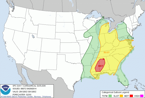
ANOTHER ROUND OF SEVERE WEATHER: The deep upper low remains anchored over the Midwest, and Alabama will remain in moist, unstable air. Another short wave rotating around the big upper low will bring yet more severe weather to our state this afternoon and tonight; SPC maintains an enhanced “moderate risk” of severe weather for a pretty decent part of the state…
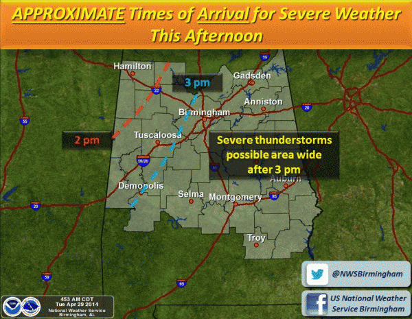
TIMING: The primary window for severe weather this time comes from about 3:00 this afternoon until 3:00 a.m. Wednesday.
The air over Alabama was pretty much worked over last night by the storms, so it will take some time to destabilize, but models suggest surface based CAPE values will rise into the 1000-2000 j/kg range by afternoon, certainly sufficient for severe weather with this kind of setup.
Unfortunately it looks like all modes of severe weather will be possible, including large hail, damaging winds, and a few tornadoes. So, like last night, you will need to be in a position to hear severe weather warnings when issued, and have a plan of action, and a readiness kit in your safe place.
FLASH FLOOD WATCH: It will remain in effect for all of Alabama through tomorrow morning; additional rains of 1-2 inches are likely, and more flash flooding issues are very possible.
Drier air and lower dewpoints will finally advect into the state tomorrow morning as the rain ends from west to east. The sun should begin to break out tomorrow afternoon.
THURSDAY/FRIDAY: These two days look dry for our part of the state with a partly sunny sky. The high Thursday will be in the upper 60s, followed by a high around 70 degrees Friday.
THE ALABAMA WEEKEND: Looks delightful with sunny warm days and fair cool nights. The high Saturday around 80, with low 80s Sunday. Perfect weekend for racing at the Talladega Superspeedway. Dry weather should continue into early next week.
WEATHER BRAINS: Don’t forget you can listen to our weekly 90 minute netcast anytime on the web, or on iTunes. This is the show all about weather featuring many familiar voices, including our meteorologists here at ABC 33/40. We will produce this week’s show Thursday night at 8:30 CT.
CONNECT: You can find me on all of the major social networks…
Facebook
Twitter
Google Plus
Instagram
Once again, stay tuned to the blog for frequent updates on the Alabama weather situation….
Category: Alabama's Weather


