Lunch Notes
I will have the muffaletta please…
Oh, not those kind of lunch notes.
Here are some lunch WEATHER notes:
…A dying MCV (mesoscale convective vortex) is between Cullman and Athens along I-65 in North Alabama. It is accompanied by a little leftover light rain. But that is about it across North and Central Alabama.
…Temperatures are in the lower and middle 70s north of I-20 and quickly approach 80F the further south you go. Areas south of I-20 are getting quite a bit of sunshine, while clouds left over from the morning activity are still thick to the north.
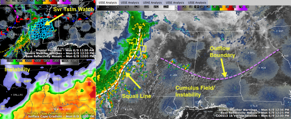
…Outflow from the early morning rains worked as far south as Marion, Clanton and Wedowee. This airmass has dewpoints in the middle and upper 60s, with 70s to the south. You can see that in the visible satellite photos, with a healthy cumulus field south of that outflow boundary. Look for that boundary from Meridian to Montgomery to be important in storm development this afternoon.
…Sure enough, showers and forming and growing along that boundary in Mississippi from Meridian back to the west northwest. Those cells are moving northeast. These will work into western Alabama, (mainly west of I-65) over the next few hours.
PAUSE FOR OBLIGATORY EXPLANATORY GRAPHIC…
BACK TO REGULARLY SCHEDULED NOTES…
…A severe thunderstorm watch is in effect for parts of Louisiana, Arkansas and western Mississippi ahead of a squall line that is moving east. There are several severe thunderstorm warnings south of Little Rock, but none in Louisiana. That line is as far east as Shreveport, moving east at 35-40 mph. It will weaken, but storms forming now in Louisiana and later in western Mississippi will become the dominant line of storms and push into western Alabama this evening. Those storms could be on the loud side, but significant severe weather doesn’t look likely.
…The upper and surface lows that are in Kansas this morning will be in Arkansas tomorrow. So still west of us, and a little closer. This means at least a couple of rounds of showers and storms tomorrow during the day. Expect highs in the lower and middle 80s with a heavy preponderance of clouds and a little sun. Parts of Alabama west of a line from Roberstdale to Prattville to Ashland to Heflin are already outlook for severe weather tomorrow. Alabama is not in the Day One Severe Weather Outlook from the SPC for today.
…The NWS in Huntsville has issued a flash flood watch that will be in effect through tomorrow evening.
…The morning run of the GFS does not pus the moisture axis eastward until noon on Thursday, giving us fewer showers and storms for Thursday afternoon and Friday.
…Triskaidekaphobics will be not be surprised that the morning run brings back rain for Friday the 13th, but keeps the weekend pretty decent.
…SPECIAL NOTE
Hey! I am getting to sit at the Weekday Desk on this second Monday of June, filling in for our Ryan Stinnett, who starts his on air television career today at WAKA in Montgomery. Never fear, Ryan will still be writing the daytime forecasts while he does weekends and will still field other responsibilities as well. Congratulations Ryan! You’re going to be great!
Category: Alabama's Weather, Severe Weather


