

It Was A Dark and Stormy Night…

…so Snoopy used to start all of his novels sitting atop his doghouse in the Charles Schultz cartoons.
It is an appropriate way to start this blog post tonight here in Central Alabama as well with widespread rain and storms now covering an area encompassing about 80 percent of the northern half of the state.
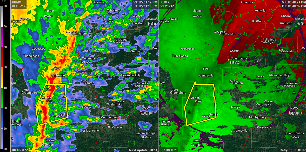
The instability is non-existent except for areas south Marengo, Hale, Perry and Dallas Counties where a severe thunderstorm warning is in effect ahead of a line of storms that extends from Birmingham to Centreville to Marion to Camden. The warning has been canceled for Hale and Marengo Counties.
Along the southern portion of the line, storms could produce damaging winds.
We will continue to track it.
Heavy rains abound as well. An areal flood advisory was just issued for Jefferson County. Be extra careful if you must be out, you procrastinators! You know who you are!
Here is the original warning.
THE NATIONAL WEATHER SERVICE IN BIRMINGHAM HAS ISSUED A
* SEVERE THUNDERSTORM WARNING FOR…
NORTHWESTERN DALLAS COUNTY IN SOUTH CENTRAL ALABAMA…
SOUTH CENTRAL HALE COUNTY IN WEST CENTRAL ALABAMA…
NORTHEASTERN MARENGO COUNTY IN SOUTHWEST ALABAMA…
PERRY COUNTY IN ALABAMA…
* UNTIL 615 PM CST
* AT 529 PM CST…THE NATIONAL WEATHER SERVICE INDICATED A LINE OF
SEVERE THUNDERSTORMS CAPABLE OF PRODUCING DAMAGING WINDS IN EXCESS
OF 60 MPH. THESE STORMS WERE LOCATED ALONG A LINE EXTENDING FROM
FAUNSDALE TO DAYTON TO CONSUL…AND MOVING NORTHEAST AT 60 MPH.
* LOCATIONS IMPACTED INCLUDE…
UNIONTOWN…MARION…SELMONT-WEST SELMONT…SELMA…NEWBERN…
CENTRAL MILLS…BOGUE CHITTO AND VAIDEN.
Category: Alabama's Weather, Severe Weather
About the Author (Author Profile)
Subscribe
If you enjoyed this article, subscribe to receive more just like it.


