Much Warmer, Then Much Colder; Ice Issues?
An all new edition of the ABC 33/40 Weather Xtreme video is available in the player on the right sidebar of the blog. You can subscribe to the Weather Xtreme video on iTunes by clicking here.
ROLLER COASTER RIDE: Yet another complex forecast for Alabama. In the short term, temperatures will be much warmer. Today’s high will be close to 70 degrees; parts of South Alabama could be close to 80 this afternoon. The sky will remain cloudy, and we will mention the chance of showers, but rain today won’t be especially widespread. In fact, a few thin spots could show up in the overcast this afternoon.
TOMORROW: Models are showing a slower progression of the Arctic front, so we stay in the warm air tomorrow. Much like today, the sky will be mostly cloudy, showers are possible, and temperatures rise up into the low to mid 70s. Coverage of rain should increase tomorrow night, and a few thunderstorms are possible ahead of the cold front. The good news is that no severe weather is expected, although a strong storm is not totally out of the question.
ARCTIC AIR INVADES: Much colder air will enter far North Alabama tomorrow evening, and the Arctic front will progress steadily southward during the night. The timing of this front’s arrival is one key in the winter storm potential for Thursday morning. We should mention we expect no icy travel issues in Alabama before midnight tomorrow night.
WINTER STORM POTENTIAL: Uncertainty has been introduced into the forecast for Thursday morning; the NAM (North American Mesoscale) model is slower with the arrival of the cold air, and it modifies the cold air enough that temperatures stay above freezing at Birmingham, Tuscaloosa, Anniston, and Gadsden. However, this is an outlier in that the ECMWF (European) and GFS (American) models show sub-freezing temperatures deep into Central Alabama. Keep in mind the cold air will be very shallow, and traditionally models struggle with this, so we will skew toward the GFS/ECMWF solution. Here is our current thinking…
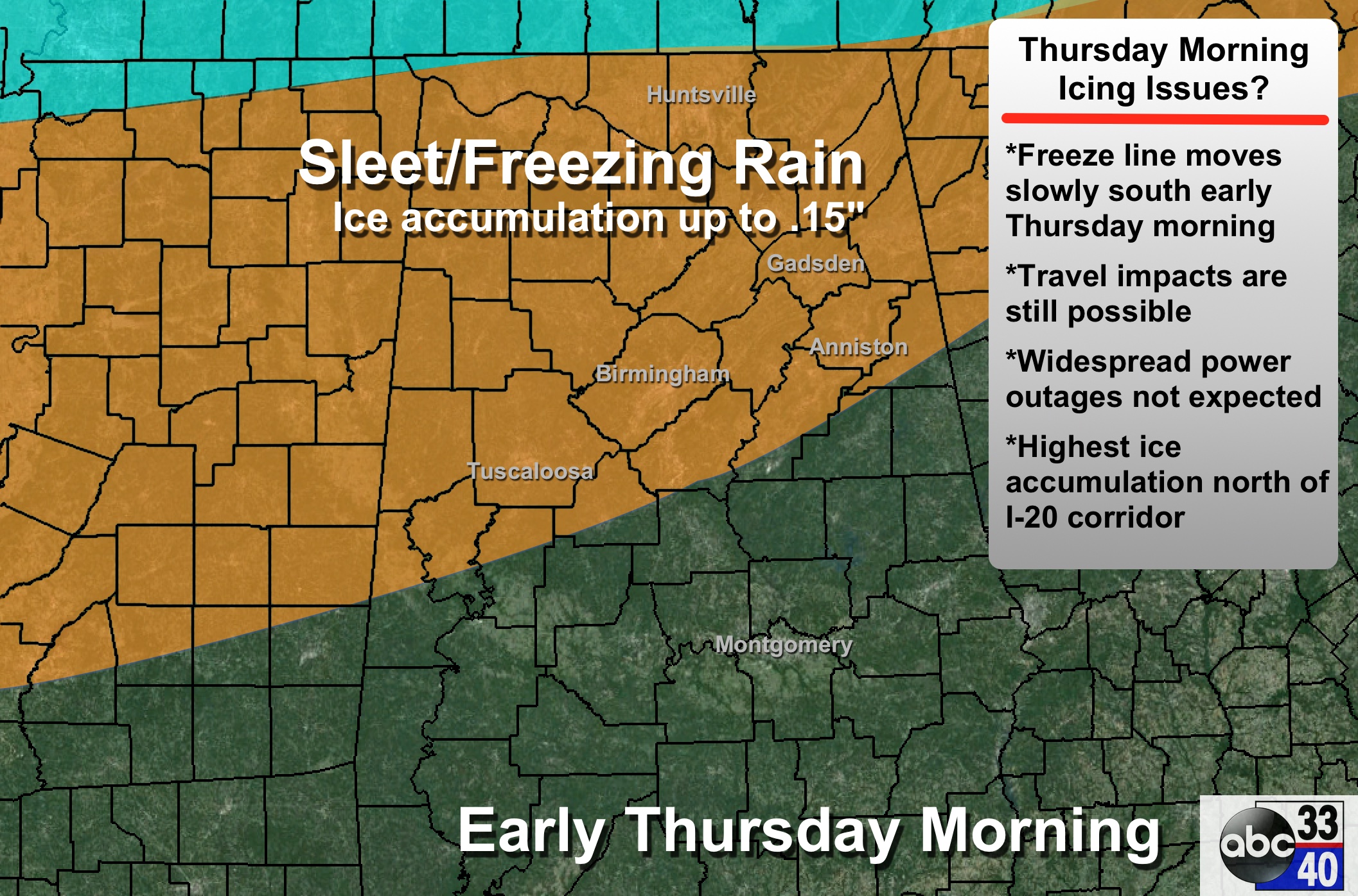
TIMING: The freeze line, and the approximate time when freezing rain begins, will be near Muscle Shoals and Huntsville at 2:00 a.m…. Cullman at 4:00 a.m…. I-59 (Birmingham, Tuscaloosa, Gadsden) at 6:00 a.m… and Anniston at 7:00 a.m.
PLACEMENT: Freezing rain and icy travel is possible Thursday morning as far south as a line from Eutaw to Calera to Heflin, but the highest ice accumulation should come over Northwest Alabama.
PRECIPITATION TYPE: Model forecast soundings suggest most of the precipitation will fall in the form of freezing rain (liquid that falls when surface temperatures are below 32 degrees). Some sleet could be in the mix as well… and snow flurries are possible later in the day Thursday as the cold air gets deeper. But no snow accumulation is expected if it we do see flurries.
ACCUMULATION: Ice accumulation up to 0.15″ is possible; the higher totals will be over Northwest Alabama. But remember, it doesn’t take much ice to create travel problems.
IMPACT: The good news is that with the lower ice accumulation potential, widespread power outages are not expected. The main issue will involve travel, especially on bridges and overpasses, where freezing rain falls.
DURATION: Temperatures will most likely stay below freezing along and north of U.S. 278 Thursday (north of a line from Hamilton to Cullman to Gadsden), so icy travel could persist in that part of North Alabama through the day Thursday into Thursday night and Friday morning. It looks like Birmingham, Tuscaloosa, Anniston, and Gadsden will creep up into the mid 30s Thursday afternoon.
IMPORTANT: When dealing with an event like this (freezing rain/sleet), the difference in one or two degrees at the surface can make the difference between a harmless, cold rainy morning, and a winter storm with high travel impact. Confidence in the timing and placement of the freeze line is not especially high, and this forecast will change as we get closer to the event. Be sure and check the blog often for updates.
FRIDAY AND THE WEEKEND: These three days will be dry and warmer with partly sunny days and mostly fair nights. The high Friday will be close to 50, with mid 50s Saturday and Sunday.
See the Weather Xtreme video for maps, graphics, and more details.
FIRST ALERT STORM TEAM TOUR: Our annual severe weather awareness tour across Alabama rolls along; tonight’s scheduled stop at Hanceville has been postponed…. we are scheduled to be in Calera at Burton Campers Thursday. Just drop by anytime from 4:00 until 6:30… you can watch me do weather live on ABC 33/40, get some free stuff to take home, and have a chance to win several NOAA Weather Radios we will be giving away. If you need your weather radio programmed or checked, bring it by and we will be glad to help.
WEATHER BRAINS: Don’t forget you can listen to our weekly 90 minute netcast anytime on the web, or on iTunes. This is the show all about weather featuring many familiar voices, including our meteorologists here at ABC 33/40. Scroll down for the show notes on the new episode we recorded last night.
CONNECT: You can find me on all of the major social networks…
Facebook
Twitter
Google Plus
Instagram
I will be at Randolph Elementary in Bibb County today… look for the next Weather Xtreme video here by 4:00 this afternoon. Enjoy the day!
Category: Alabama's Weather
About the Author (Author Profile)
James Spann is one of the most recognized and trusted television meteorologists in the industry. He holds the AMS CCM designation and television seals from the AMS and NWA. He is a past winner of the Broadcast Meteorologist of the Year from both professional organizations.Subscribe
If you enjoyed this article, subscribe to receive more just like it.


