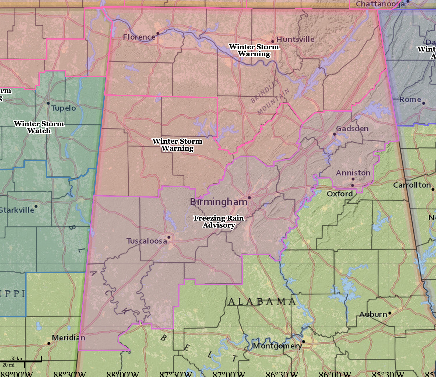
Winter Storm Warning Tomorrow
An all new edition of the ABC 33/40 Weather Xtreme video is available in the player on the right sidebar of the blog. You can subscribe to the Weather Xtreme video on iTunes by clicking here.
MUST BE MARCH IN ALABAMA: Montgomery has soared to 80 degrees this afternoon, at the time NWS offices in Birmingham and Huntsville were issuing winter storm warnings and freezing rain advisories for North Alabama that will be in effect tomorrow.
SEVERE STORMS? Despite the sharp thermal contrast, no severe weather is expected along the Arctic front tonight. Thunderstorms are possible, but they stay under severe limits.
ICY MESS TOMORROW: In the winter storm warning area, ice accumulation to 0.30″ is possible…. amounts from 0.01 to 0.20″ are possible in the freezing rain advisory…
TIMING: See the yellow line on the forecast below…
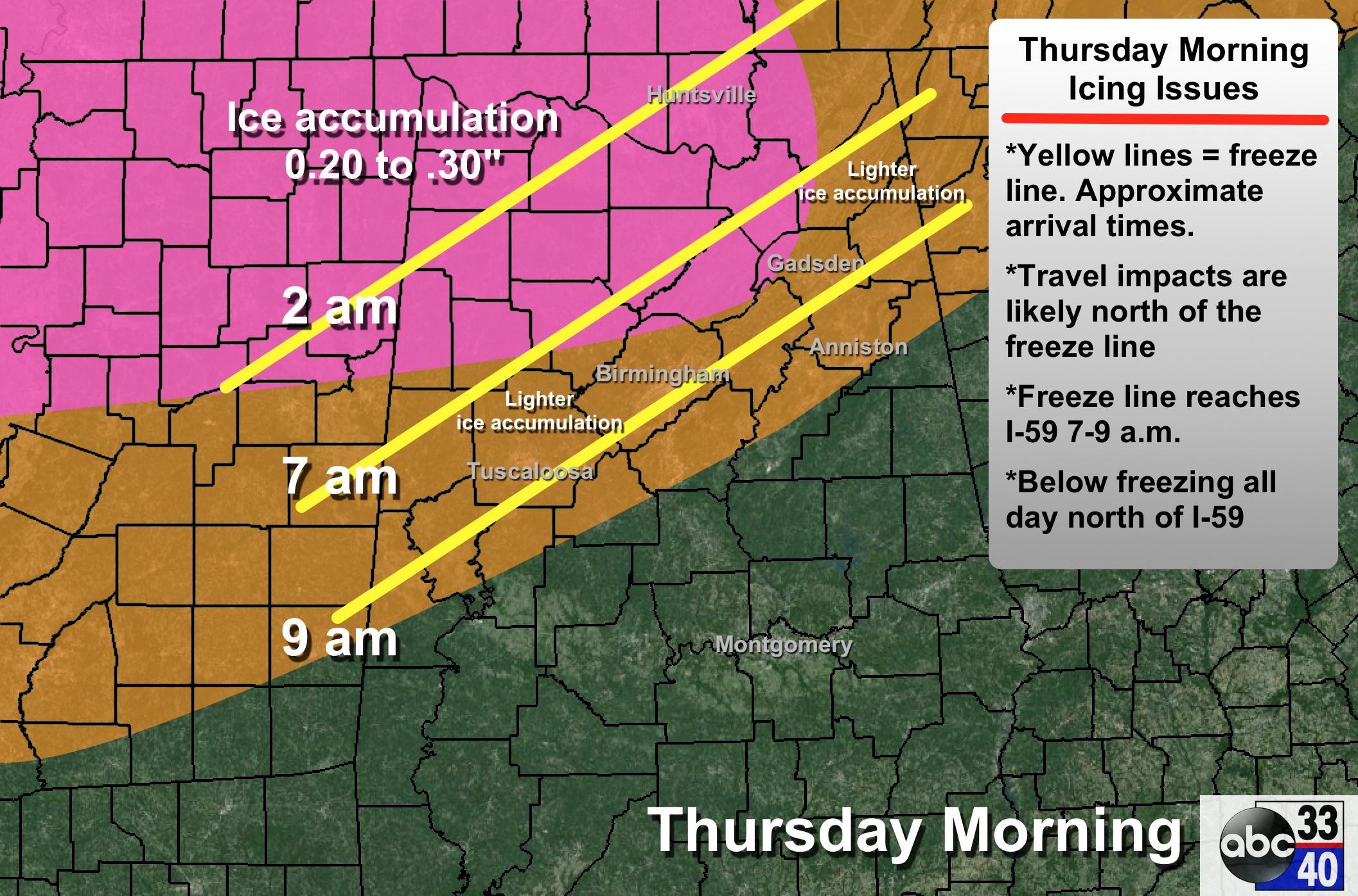
This is actually one of the hardest parts of the forecast; models don’t handle shallow layers of cold air very well, so be ready for changes. We project the freeze line to be in the Birmingham metro in the 7-9 a.m. time frame.
PLACEMENT: The southern extent of the ice accumulation should be close to a line from Forkland to Brent to Alabaster to Oxford. Again, defining this line is very difficult; that the best forecast we have for now. The ice potential for Tuscaloosa and Anniston is a very close call; southern parts of those cities could have a cold rain and 34 degrees, while the northern parts have freezing rain, icy bridges, and 31 degrees.
PRECIPITATION TYPE: Most of this event will be freezing rain (liquid falling with surface temperatures at or below 32 degrees), or sleet (ice pellets). Some light snow is possible as it all winds down tomorrow afternoon and the cold air gets deeper.
IMPACT: In the winter storm warning areas, where the ice accumulation could be 0.30″ in spots, scattered power outages are possible due to the weight of the ice on trees and power lines, and a north wind of 10-20 mph. Bridge icing is likely anywhere freezing rain falls; it doesn’t take much to bring a nasty coating of ice on bridges and overpasses. The warmth today should mitigate ice potential to some degree on black top roads, you need to expect ice on any bridge or road tomorrow where temperatures are below 32 degrees.
DURATION: Much of North Alabama will stay below freezing all day tomorrow, so icy travel issues will likely continue through tomorrow night, and maybe even into Friday morning. Temperatures rise above freezing at mid-morning Friday when conditions improve greatly.
IMPORTANT: We have a limited skill set in dealing with freezing rain events like this, and due to the shallow nature of the cold air I fully expect surprises. Keep a close eye on the blog for forecast changes as we get closer to the event tonight and tomorrow morning.
FRIDAY AND THE WEEKEND: The weather will be dry and warmer. We reach the upper 40s Friday, and upper 50s are likely Saturday and Sunday. A wave will bring some scattered clouds Sunday, but for now the air looks too dry to mention showers.
NEXT WEEK: Getting some decent agreement now that rain will return to our state on Tuesday… see the Weather Xtreme video for maps, graphics, and more details.
ALABAMA POWER IS READY, ARE YOU? Our friends at Alabama Power are monitoring the forecast closely, ready to deploy people and assets to quickly address any outages that might occur. Read a special message from Ike Piggot about their commitment to their customers.
WEATHER BRAINS: Don’t forget you can listen to our weekly 90 minute netcast anytime on the web, or on iTunes. This is the show all about weather featuring many familiar voices, including our meteorologists here at ABC 33/40.
CONNECT: You can find me on all of the major social networks…
Facebook
Twitter
Google Plus
Instagram
I had a great time today visiting with the second graders at Chelsea Park Elementary School in Shelby County… be looking for them on the Pepsi KIDCAM today at 5:00 on ABC 33/40 News! The next Weather Xtreme video will be posted here by 7:00 a.m. tomorrow… and I will have more forecast updates later this evening. Stay tuned…
Category: Alabama's Weather
About the Author (Author Profile)
James Spann is one of the most recognized and trusted television meteorologists in the industry. He holds the AMS CCM designation and television seals from the AMS and NWA. He is a past winner of the Broadcast Meteorologist of the Year from both professional organizations.Subscribe
If you enjoyed this article, subscribe to receive more just like it.


