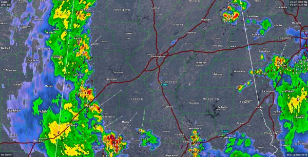
Showers and Storms over West Alabama
A line of showers and thunderstorms has been progressing across Mississippi this afternoon and made it into Alabama around 5:30. It extends from Hamilton and Sulligent in Marion and Lamar Counties to Reform in Pickens County to near Eutaw in Greene County and on to south of Thomaston in Marengo County.
Lots of lightning all along the line but the storms have not been severe. They also have torrential rain and gusty winds. There is the potential for some dime to nickel size hail and wind gusts 40-60 mph. There was some small hail near Gadsden and Weaver in East Alabama.
The line is some 50-55 miles west of Birmingham and moving east at 15-20 mph. Simple extrapolation indicates it could each I-65 around 9:30-10 p.m.
The storm in Cherokee County was responsible for the earlier small hail near Gadsden and Weaver. It has recently produced wind damage including trees down near CR-19/6 in the Mr. Weisner community.
The storm in Marengo County is closest to being severe now, with some small hail in it. This storm could briefly become severe with a damaging wind gust.
Storms from Wetumpka down through Montgomery are strong as well.
The storms are moving into an area characterized by moderate instability and weak wind shear, so they will hold together across much of Central Alabama this evening The trigger is an eastward moving upper trough with its axis aligned from Little Rock to Alexandria LA this evening.
Earlier storms over Southeast sections of Central Alabama were briefly severe and triggered warnings. No severe weather was reported.
Category: Alabama's Weather


