

Alabama’s Weather Trending Drier
RADAR CHECK: So far showers and storms are widely spaced across the great state of Alabama this afternoon, and the ones in progress should fade away soon after the sun goes down later this evening.

REST OF THE WEEK: An upper low north of Memphis is drifting to the southeast, and drier air working into the circulation will move into Alabama tonight, and this should bring a considerable reduction in the number of showers and storms each day for the rest of the week. In fact, you could make an argument that we can take out the chance of rain for much of the state over the next few days, but this is June and it is hard to find a day completely without showers.
Bottom line is that we will forecast only isolated afternoon showers tomorrow through Friday, and most of those will be over the eastern third of the state. Days will be partly sunny, and temperatures will trend warmer with more sunshine; most days will feature a high in the mid 80s. Upper 80s are possible by Thursday and Friday afternoon.
THE ALABAMA WEEKEND: Not much change; best chance of showers and storms should remain east of Alabama… we will only forecast widely scattered afternoon showers Saturday and Sunday; seems like the higher coverage will be Sunday, but even then many places will stay dry. Highs will be in the 86-89 degree range both days.
And, for now, next week looks pretty routine for June in Alabama with partly sunny, warm, humid days with a few widely scattered showers or storms each afternoon. Highs will be in the upper 80s… see the blog and the Weather Xtreme video for maps, graphics, and more details.

HURRICANE SEASON BEGINS: Today marks the first day of the Atlantic/Gulf of Mexico hurricane season, and with general sinking motion across the tropics things are very quiet. We do note a major hurricane over in the eastern Pacific, Andres, but that will weaken and dissipate over the open water far from land over the next five days.

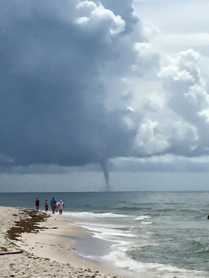
GULF COAST WEATHER: A waterspout developed near Orange Beach and Perdido Key this morning (photo below from Ashley Dark)…
The weather looks pretty nice for the rest of the weekend from Panama City over to Gulf Shores… mostly sunny days and fair nights with only widely scattered showers or storms. Highs will be in the low 80s on the immediate coast, with mid to upper 80s inland. Sea water temperatures are mostly in the low 80s.
WEATHER BRAINS: Don’t forget you can listen to our weekly 90 minute netcast anytime on the web, or on iTunes. This is the show all about weather featuring many familiar voices, including our meteorologists here at ABC 33/40. We will produce this week’s show tonight at 8:30 CT… you can watch it on “James Spann 24/7” on cable systems around the state, or on the web here.
CONNECT: You can find me on all of the major social networks…
Facebook
Twitter
Google Plus
Instagram
Look for the next Weather Xtreme video here by 7:00 a.m. tomorrow…
Category: Alabama's Weather
About the Author (Author Profile)
James Spann is one of the most recognized and trusted television meteorologists in the industry. He holds the AMS CCM designation and television seals from the AMS and NWA. He is a past winner of the Broadcast Meteorologist of the Year from both professional organizations.Subscribe
If you enjoyed this article, subscribe to receive more just like it.


