

Drier Days Ahead For Alabama
FOGGY START: A dense fog advisory remains in effect for much of Central Alabama early this morning; visibility is down to a fraction of a mile in spots… that fog will burn off by mid-morning.
Then, for the rest of the day, the sky will be partly to mostly sunny with only isolated showers or storms this afternoon, and mainly over the eastern half of the state. Drier air has moved into West Alabama, rotating around the bottom of an upper low just north of our state. The low will keep drifting southeast, bringing a warmer and drier pattern through the rest of the week.
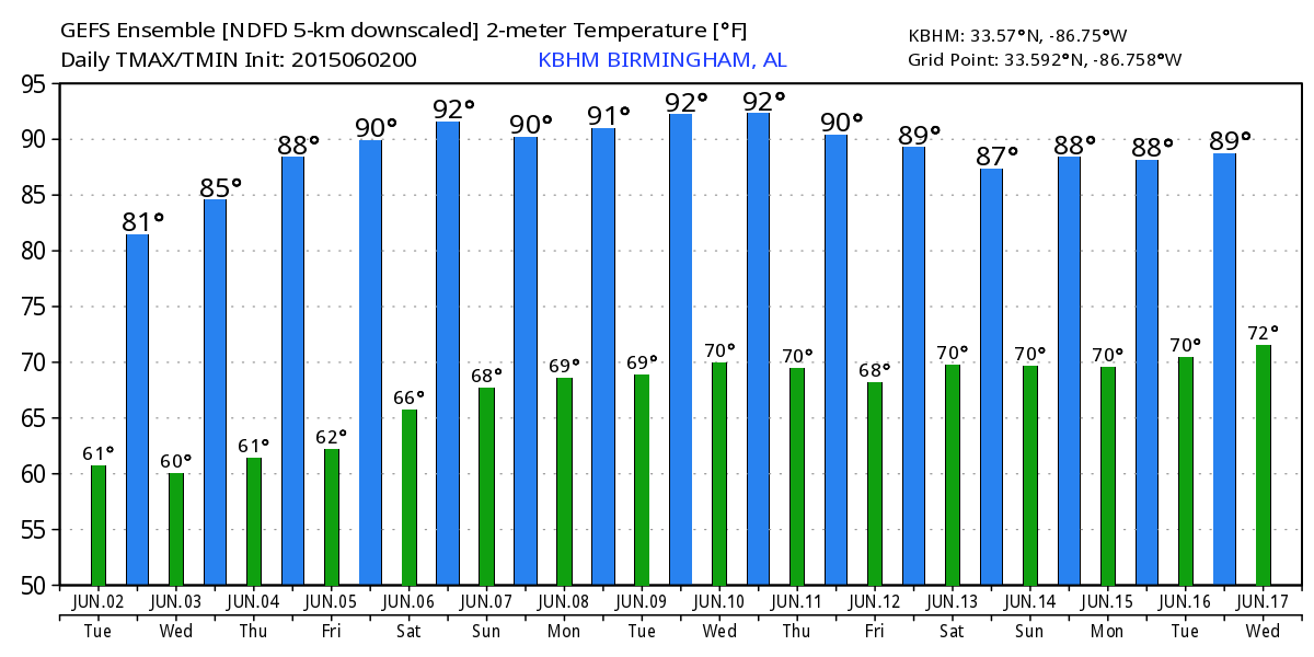
TOMORROW THROUGH FRIDAY: Mostly sunny days, fair nights, a warming trend, and few, if any showers around here. The chance of any one spot getting wet is only one in ten, barely worth mentioning in the forecast. We reach the upper 80s by Thursday, and some places could touch 90 degrees Friday. After all, this is June in Alabama.
OUR WEEKEND: Saturday looks warm and dry with a high close to 90 degrees; we will probably need to bring back the risk of isolated showers Sunday afternoon, but even then most communities will stay dry. The high Sunday will also be very close to 90 degrees.
NEXT WEEK: Moisture levels rise, and we will mention “scattered, mostly afternoon and evening showers and thunderstorms” Monday and Tuesday with a mix of sun and clouds both days along with a high between 87 and 90 degrees. See the Weather Xtreme video for maps, graphics, and more details.
AT THE BEACH: Mostly sunny days, fair nights through the weekend from Panama City west to Gulf Shores with only isolated showers or thunderstorms. Highs on the immediate coast will be in the low to mid 80s, with afternoon temperatures in the 87 to 90 degree range inland. The sea water temperature early this morning at the Dauphin Island Sea Lab is 81 degrees.
TROPICS: The Atlantic basin is quiet on this second day of the 2015 hurricane season. No tropical storm formation through mid-week. Over in the eastern Pacific, Tropical Storm Blanca will become a hurricane later today, and is expected to reach major hurricane status by tomorrow. It is headed for the southern tip of Baja California, but will weaken considerably by the time it approaches the peninsula.
WEATHER BRAINS: Don’t forget you can listen to our weekly 90 minute netcast anytime on the web, or on iTunes. This is the show all about weather featuring many familiar voices, including our meteorologists here at ABC 33/40. Scroll down for the show notes on the new episode we recorded last night.
CONNECT: You can find me on all of the major social networks…
Facebook
Twitter
Google Plus
Instagram
I will be at Linn Park in downtown Birmingham today participating in the “10,000 Scoop Challenge” to raise money for the Salvation Army. We are giving away free scoops of Mayfield Dairy Ice Cream… for each scoop we give away, Moose Tracks ice cream donates $1 to The Salvation Army of Birmingham to support existing programs. Look for the next Weather Xtreme video here by 4:00 this afternoon… enjoy the day!
Category: Alabama's Weather
About the Author (Author Profile)
James Spann is one of the most recognized and trusted television meteorologists in the industry. He holds the AMS CCM designation and television seals from the AMS and NWA. He is a past winner of the Broadcast Meteorologist of the Year from both professional organizations.Subscribe
If you enjoyed this article, subscribe to receive more just like it.


