Highs Stay In The 90s All Week
SUMMER HEAT: On the maps this morning, an upper air high, representing the center of scorching summer heat, is over Texas and Oklahoma. We are on the eastern periphery of this upper high, but we still expect highs in the 90s every day this week. After all, this is mid July in Alabama.
We do note the NWS in Birmingham has a “heat advisory” for areas generally along and west of I-65, and no advisory to the east. One way or another, everybody will experience hot afternoons this week. We don’t like to insult your intelligence on this blog by telling you to “go into an air conditioned room” and “drink water”, I think Alabamians know how to stay cool.
STRONG STORMS? A significant severe weather event is likely today and tonight north of our state; SPC has a “moderate” risk of severe weather up from northern Illinois down into Kentucky.
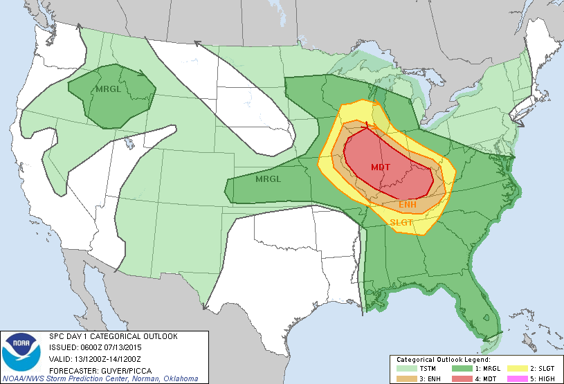
Far North Alabama is in the standard “slight risk” later today, with a “marginal risk” for the rest of the state. Understand, storms later today and early tonight will be very widely separated, but where the storms do form they could be strong with gusty winds and potential for a wet microburst or two. And, of course, all summer storms pack gobs of lightning.
TOMORROW: North Alabama is in a “slight risk”, with much of the rest of the state under a “marginal risk” of severe weather, as defined by the Storm Prediction Center…
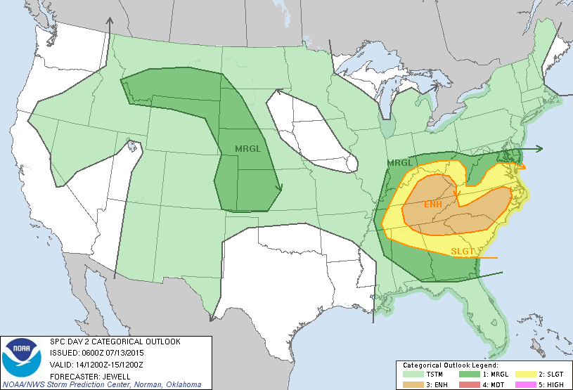
Storms tomorrow afternoon will remain isolated, but the high resolution NAM model is showing an organized band of storms (an MCS, or mesoscale convective system) moving into the state late tomorrow night. Below is the output valid just after midnight tomorrow night…
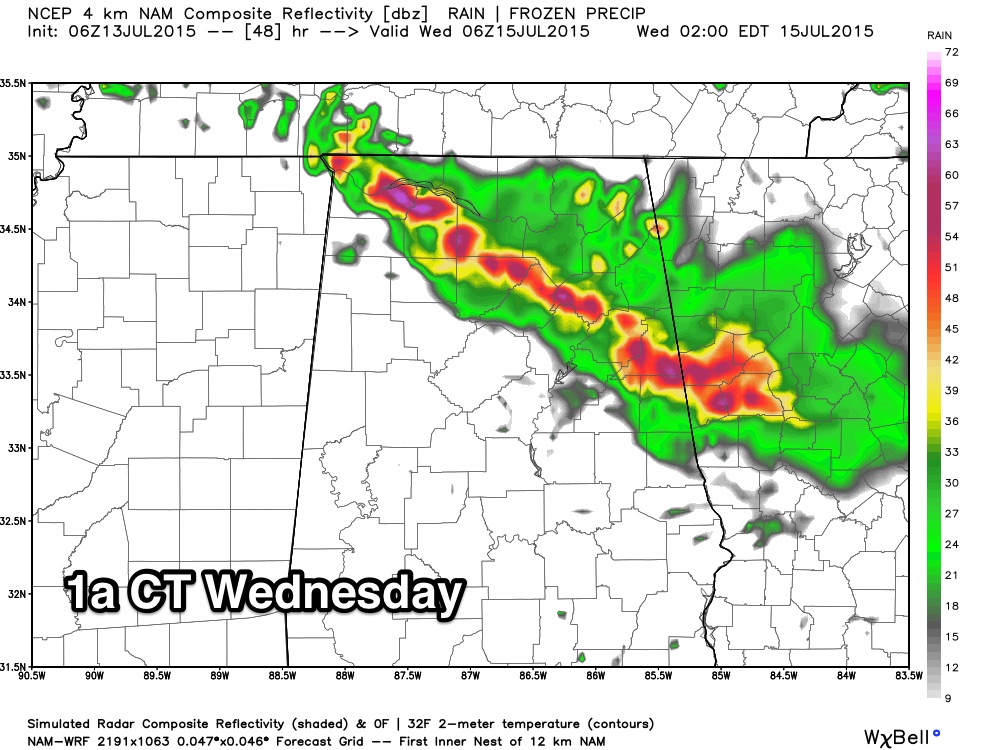
No actual guarantee this will happen, but under the pattern it is certainly possible, and we will watch model trends. If this line does arrive, it could produce strong winds.
WEDNESDAY THROUGH THE WEEKEND: An upper ridge will stay in place, meaning very routine summer weather. Hot, hazy days… fair, humid nights… and the risk of an afternoon or evening storm in a few spots. Highs in the 90s, lows in the 70s. The good ole “dog days”.
NEXT WEEK: No overall change… hot, muggy summer weather continues with the daily risk of a “pop up” thunderstorm in spots. See the Weather Xtreme video for maps, graphics, and more details.
AT THE BEACH: Looking good on the coast from Panama City Beach west to Gulf Shores this week, with mostly sunny days, fair nights, and the standard risk of a passing storm at times. Highs on the immediate coast will be in the 87 to 90 degree range, with mid 90s inland. The sea water temperature at the Dauphin Island Sea Lab early this morning is 85 degrees.
TROPICS: A weak disturbance off the middle Atlantic coast of the U.S. is moving northeast with little chance of development… the rest of the Atlantic basin remains very quiet.
ON THIS DATE IN 1980: The horrible heat wave of 1980 was in its fourth week as temperatures continued to roar. In Nebraska, one church congregation was trying Christmas music to help them feel cooler. Mammoth Cave in Kentucky was doing a brisk business. That Sunday, July 13th was the hottest day in the heat wave for Birmingham, as the mercury at the Airport reached 106. That was just one degree short of the all time record high in the Magic City.
WEATHER BRAINS: Don’t forget you can listen to our weekly 90 minute netcast anytime on the web, or on iTunes. This is the show all about weather featuring many familiar voices, including our meteorologists here at ABC 33/40. We will produce this week’s show tonight at 8:30 CT… you can watch it on “James Spann 24/7” on cable systems around the state, or on the web here.
I will be doing a weather program this morning at Camp Trinity Summer Enrichment, at Trinity Baptist Church in Birmingham. Look for the next Weather Xtreme video here by 4:00 this afternoon… enjoy the day!
Category: Alabama's Weather
About the Author (Author Profile)
James Spann is one of the most recognized and trusted television meteorologists in the industry. He holds the AMS CCM designation and television seals from the AMS and NWA. He is a past winner of the Broadcast Meteorologist of the Year from both professional organizations.Subscribe
If you enjoyed this article, subscribe to receive more just like it.


