Interesting Look at Strong El Niño Years
With the expected presence of a strong El Niño for the rest of Fall and into the Winter season, I’ve been trying to look at how the Alabama weather responded in past El Niños. But that is not an easy task with limited access to the tons of data available. Fortunately, the National Centers for Environmental Information, who does have access to the mountains of data, has prepared the map below showing what happened to the rainfall as a percent of average in those years with a strong El Niño back to 1957.
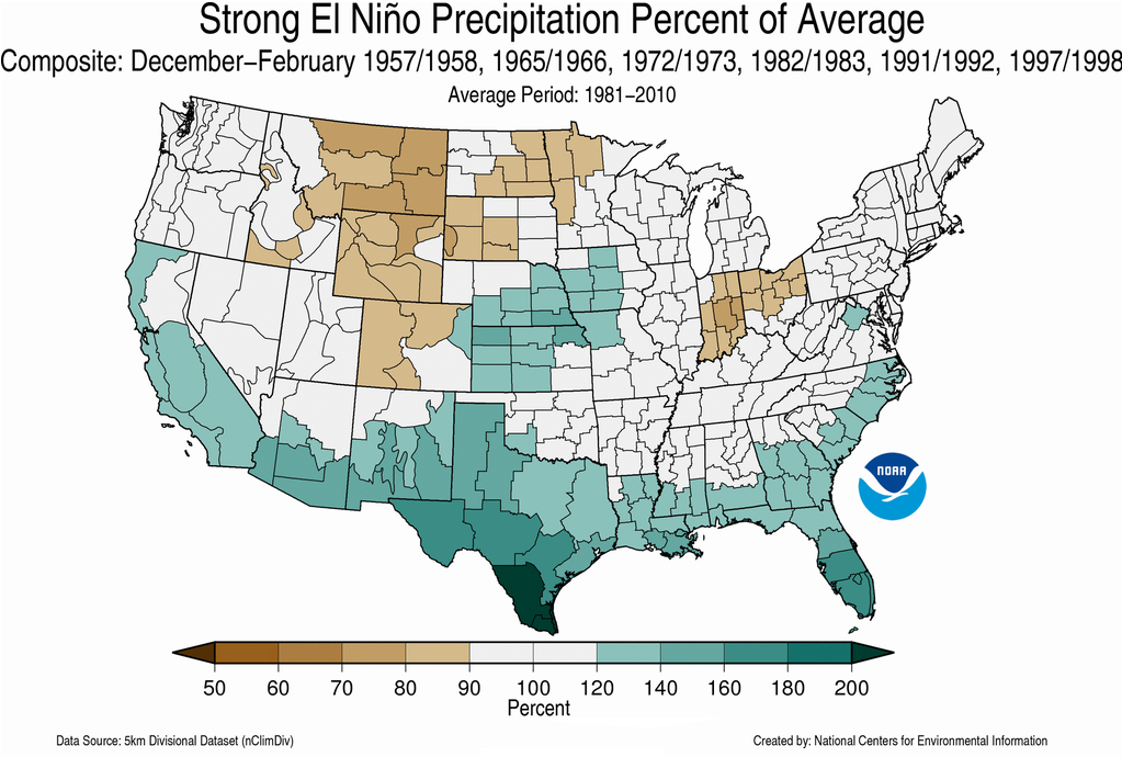
As you can see, the southern tier of Alabama experienced a relatively wet period with rainfall at 120 to 140 percent of average. Central and North Alabama fell within the category of 90 to 120 percent of average rainfall.
This would suggest some dreary late Fall and Winter days for a fairly large chunk of the Southeast US. The higher than average amounts of precipitation along the Gulf Coast all the way from South Texas to South Florida suggests that we may see a number of Gulf lows to generate all of that precipitation which may also suggest some threats for winter weather events further north away from the Gulf Coast. Only time will tell!
-Brian-
Category: Alabama's Weather
About the Author (Author Profile)
Brian Peters is one of the television meteorologists at ABC3340 in Birmingham and a retired NWS Warning Coordination Meteorologist. He handles the weekend Weather Xtreme Videos and forecast discussion and is the Webmaster for the popular WeatherBrains podcast.Subscribe
If you enjoyed this article, subscribe to receive more just like it.


