

Strong Storms Late In The Weekend
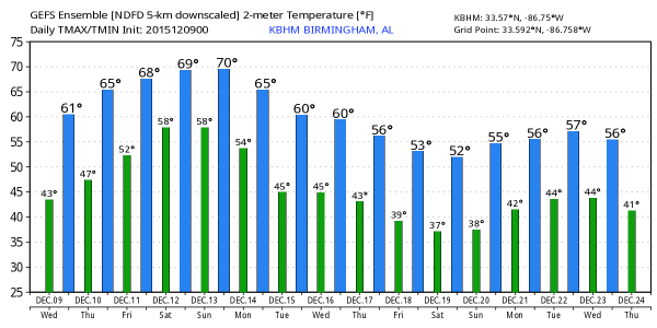
A FEW SPRINKLES TODAY? A short wave aloft will pass over Alabama today; moisture is very limited, but it could squeeze out a few showers or sprinkles across the northern counties this afternoon. The chance of any one spot getting wet is only about one in ten… otherwise today will feature a mix of sun and clouds with a high in the low 60s this afternoon.
TOMORROW THROUGH SATURDAY: These three days will feature a warming trend; we expect a high in the upper 60s tomorrow, around 70 Friday, followed by low 70s Saturday. In fact, the 00Z GFS is printing a high of 74 for Birmingham Saturday… if that verifies, it will be within 4 degrees of the record high, 78 set in 1971.
Moisture levels will slowly rise, so there will be cloudy periods, but the chance of rain is very small, and most communities stay dry through Saturday.
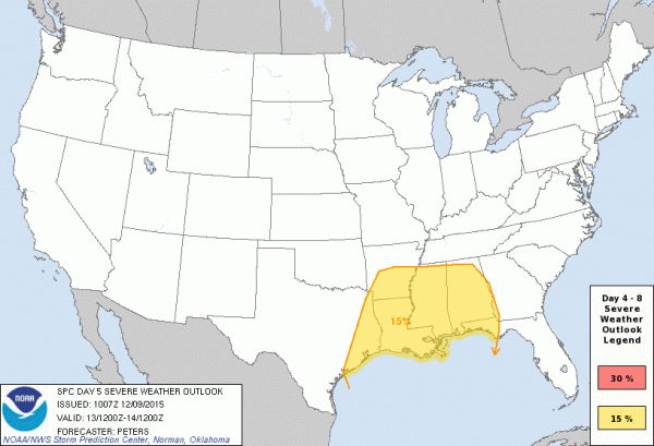
SEVERE WEATHER THREAT SUNDAY NIGHT: SPC has almost all of Alabama in a risk of severe weather on their “Day Five” outlook, which includes Sunday and Sunday night, through 6:00 a.m. CT Monday.
Here is the latest thinking:
TIMING: Models are becoming more consistent, and confidence is higher. There is a decent chance much of the day Sunday will be dry, with only a few scattered showers; temperatures will rise into the low 70s Sunday afternoon. The primary window for strong to severe storms will come from about 9:00 p.m. Sunday through 6:00 a.m. Monday.
THREATS: No doubt strong, potentially damaging straight line winds with a line of storms will be the primary concern. The low level jet (5,000 feet off the ground) will be in excess of 50 knots, and it won’t take much to get some of that down to the surface with the stronger thunderstorms. But, there is a pretty high degree of helicity (veering of the wind with altitude), and a few small, spin-up tornadoes will be possible within the line.
This is your classic cold season case of very good dynamics, but marginal thermodynamics (high shear, low CAPE). Looks like we will be burning the midnight oil Sunday night… but understand we are still several days away and the forecast could change, so keep up with the latest blog posts here.
MONDAY: Rain and storms will end during the morning, followed by clearing late in the day. It will be cooler with a high between 57 and 60 degrees.
REST OF NEXT WEEK: Tuesday looks dry, and perhaps a decent part of the day Wednesday. Then, we will mention a chance of showers, and possibly a thunderstorms Wednesday night and Thursday with a passing front… for now this doesn’t look like a severe weather threat or big rain event. See the Weather Xtreme video for more details, maps, and graphics.
CHRISTMAS: The pattern still favors mild weather for the eastern half of the nation, with cold air out west. Of course, there is no skill in a specific forecast this far out.
FOOTBALL WEATHER: Jacksonville State will host Charleston Southern Friday night (7:00p CT kickoff) at Burgess Snow Field in the FCS quarterfinals; the sky will be mostly fair with temperatures falling from 68 at kickoff, into the low 60s by the final whistle. Very comfortable for December.
AT THE BEACH: Mostly sunny days, fair nights on the coast from Gulf Shores over to Panama City Beach through Sunday; showers and storms return Sunday night into Monday morning. See the complete Gulf Coast 7 Day Planner here. The Gulf Coast Beach Forecast is presented by Gulf Shores Plantation by Mandoki Hospitality Vacation Rentals. Escape to Gulf Shores Plantation where memories last a lifetime.
WEATHER BRAINS: Don’t forget you can listen to our weekly 90 minute netcast anytime on the web, or on iTunes. This is the show all about weather featuring many familiar voices, including our meteorologists here at ABC 33/40.
CONNECT: You can find me on all of the major social networks…
Facebook
Twitter
Google Plus
Instagram
I will be speaking to a group of high school students this morning in Jacksonville… look for the next Weather Xtreme video here by 4:00 this afternoon. Enjoy the day!
Category: Alabama's Weather
About the Author (Author Profile)
James Spann is one of the most recognized and trusted television meteorologists in the industry. He holds the AMS CCM designation and television seals from the AMS and NWA. He is a past winner of the Broadcast Meteorologist of the Year from both professional organizations.Subscribe
If you enjoyed this article, subscribe to receive more just like it.


