Severe Weather Threat Wednesday
WARMER, UNSETTLED WEATHER AHEAD: This will be a very busy week in the weather office with potential for heavy rain and severe weather as we approach Christmas. I always encourage you to watch the Weather Xtreme video, which will give you a look at all of the maps and graphics that go with this discussion.
Let’s take it one day at a time.
TODAY: Rain is falling as the day begins over parts of North and West Alabama…
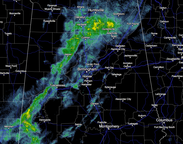
Rain will be fairly widespread today and tonight as moist air returns to the state. We reach the low 60s this afternoon, and there is no risk of severe storms, and probably no thunder.
TOMORROW: The El Nino “blow torch” fires up; the high will be close to 70 degrees. Showers are possible, and possibly a thunderstorm, but it won’t rain all day, and you might even see a glimpse of the sun occasionally. Storms tomorrow afternoon and tomorrow night could be pretty strong over South Alabama, where there is a “marginal” severe weather risk defined by the Storm Prediction Center.
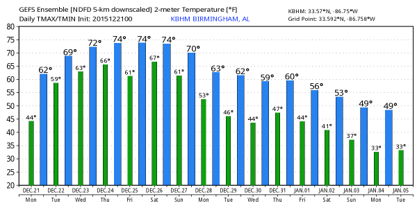
WEDNESDAY: This will be an active weather day, with the risk of severe thunderstorms and heavy rain statewide. Temperatures rise into the 71-74 degree range Wednesday, with dewpoints rising up into the 60s.
TIMING: While I can’t totally rule out a severe storm during the morning, the main window for severe thunderstorms will come from about 12:00 noon Wednesday through 12:00 midnight Wednesday night. It is impossible to give start/stop times for any one specific location; just be aware severe thunderstorms are possible anytime within this 12 hour window.
PLACEMENT: SPC has defined the standard “slight risk” of severe thunderstorms generally north of I-59, with a “marginal risk” south of I-59.
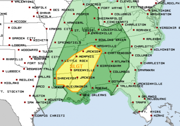
The best combination of shear and instability will be in that “slight risk” area, but severe storms are possible statewide.
MODES: Thunderstorms Wednesday and Wednesday night will be capable of producing damaging straight line winds, and a few tornadoes. The highest risk of tornadoes will be along and north of I-59 in the “slight risk” area… with a lower risk in the “marginal risk” south of I-59.
FLOODING POTENTIAL: Rain amounts of 1-3 inches are likely through Wednesday night across the northern half of the state, with potential for 4-6 inches over the southern quarter of the state.
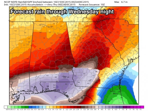
Needless to say, the highest flood threat will be over South Alabama, but localized issues are possible to the north as well.
On a positive note, there is some chance that rain and storms over South Alabama could reduce the good inflow of moisture up into the northern half of the state, reducing the severe weather threat, but that is only an outside chance.
THURSDAY/FRIDAY: Showers remain possible Christmas Eve and Christmas Day, but severe weather is not expected as the main dynamic support lifts away. The weather will be warm, with potential for highs in the mid 70s. The record high for December 24 is 77 set in 1974, doubtful we break that. But, the record for Christmas Day is 74 set in 1987… we will be very close to that level this year. See this post for more on historic Christmas warmth in Alabama.
THE WEEKEND: Not much change; warm, moist air remains over Alabama, and showers are possible Saturday and Sunday. But, there will be some decent breaks in the rain, and severe weather is not expected. Highs remain in the low to mid 70s.
NEXT WEEK: Another dynamic system will bring the risk of strong, maybe severe thunderstorms to Alabama Monday, then drier and cooler air follows for mid-week. Again, see the Weather Xtreme video for maps, graphics, and more details.
AT THE BEACH: The weather will be warm and wet at times this week along the coast from Panama City Beach over to Gulf Shores, See the complete Gulf Coast 7 Day Planner here. The Gulf Coast Beach Forecast is presented by Gulf Shores Plantation by Mandoki Hospitality Vacation Rentals. Escape to Gulf Shores Plantation where memories last a lifetime.
WEATHER BRAINS: Don’t forget you can listen to our weekly 90 minute netcast anytime on the web, or on iTunes. This is the show all about weather featuring many familiar voices, including our meteorologists here at ABC 33/40. We will produce this week’s show tonight at 8:30 CT… you can watch it here.
CONNECT: You can find me on all of the major social networks…
Facebook
Twitter
Google Plus
Instagram
Look for the next Weather Xtreme video here by 4:00 this afternoon… enjoy the day!
Category: Alabama's Weather
About the Author (Author Profile)
James Spann is one of the most recognized and trusted television meteorologists in the industry. He holds the AMS CCM designation and television seals from the AMS and NWA. He is a past winner of the Broadcast Meteorologist of the Year from both professional organizations.Subscribe
If you enjoyed this article, subscribe to receive more just like it.


