Severe Storms Likely Wednesday
THIS AFTERNOON: Light rain continues to fall over North Alabama, mainly north of I-20…
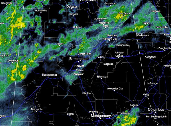
Periods of rain will continue tonight with temperatures possibly rising slowly through the night thanks to warm air advection. No severe weather tonight, and probably no thunder for the northern half of the state. We do note SPC has a “marginal” severe weather risk defined for far South Alabama tonight where the air has become unstable.
TOMORROW: We warm into the low 70s; the sky will stay generally cloudy, and we will mention a chance of showers and possibly a thunderstorm. The best chance of stronger storms tomorrow will stay over South Alabama, where a “marginal” severe weather risk continues. It won’t rain all day tomorrow, and you might even see a glimpse of the sun at times.
SEVERE WEATHER THREAT WEDNESDAY: Parameters are coming together for a potential high impact severe weather event for much of Alabama. Temperatures rise into the low 70s, and dewpoints surge into the high 60s by afternoon.
Here is a look at our current thinking…
TIMING: The main window for severe storms will come from 12:00 noon Wednesday through 12:00 midnight Wednesday night. We can’t rule out a strong storm Wednesday morning over West Alabama, however.
PLACEMENT: The best combination of instability (the ability of air parcels to rise freely) and shear (a change of wind direction with altitude) will be generally north of I-59… or from Tuscaloosa to Birmingham to Gadsden to Fort Payne and points north. This is where the highest tornado risk will be; however, a few tornadoes are possible just about anywhere over the northern half of the state. The tornado threat for South Alabama will be much more limited.
The chart below is the forecast STP, or significant tornado parameter, valid at 6:00 p.m. CT Wednesday.
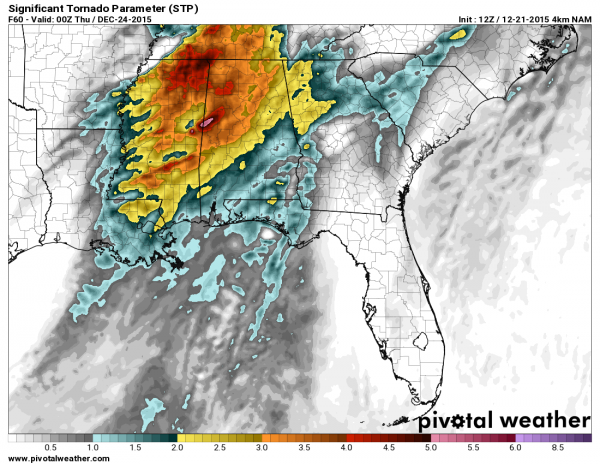
MODES: In addition to the potential of tornadoes, storms are also going to be capable of producing damaging straight line winds.
RAIN: Rain amounts of 1-2 inches are likely over the state Wednesday; some local flooding issues are possible.
CONFIDENCE LEVEL: After a review of the 12Z model set, confidence is increasing that this could be a significant severe weather threat for Alabama. One potential issue would be convection near the Gulf Coast that will block the inflow of warm, moist air into North Alabama, mitigating the severe weather risk, but the morning models aren’t showing much going on to the south.
Read this post and think about being ready in case we do have severe weather issues Wednesday.
WILL THIS BE LIKE APRIL 27, 2011? I actually choose not to answer that question any more. Of course, the answer is no; April 27, 2011 was a generational event. But please understand this; if all we have is one tornado in the entire state, and if that one tornado happens to come down your street, then that day is YOUR April 27.
THIS IS TORNADO SEASON: Having severe weather in November and December is NOT unusual… this is the tornado season here (our late fall season).
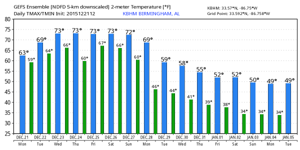
THURSDAY: While the main dynamic support pulls away, there is still some potential for strong storms over the southern half of the state on Christmas Eve. No tornado threat, however. And, we will maintain the risk of showers over the northern half of the state as drier air will have a very hard time dropping southward into Alabama. The 12Z GFS is printing a high of 76 degrees Thursday, within one degree of the record (77, set in 1964).
CHRISTMAS DAY: The weather stays mostly cloudy, warm, and showery. No severe weather, but showers will remain possible with a high in the low to mid 70s, very close to the record high of 74, set in 1987.
THE ALABAMA WEEKEND: No real change. Warm with a chance of showers Saturday and Sunday. Mostly cloudy both days with a high in the low to mid 70s.
NEXT WEEK: Another dynamic system will bring the risk of strong, possibly severe thunderstorms Monday or Monday night; see the Weather Xtreme video for maps, graphics, and more details. Temperatures trend cooler after that storm system.
AT THE BEACH: Warm, unsettled weather continues along the Gulf Coast this week with a daily risk of showers and thunderstorms; See the complete Gulf Coast 7 Day Planner here. The Gulf Coast Beach Forecast is presented by Gulf Shores Plantation by Mandoki Hospitality Vacation Rentals. Escape to Gulf Shores Plantation where memories last a lifetime.
WINTER SOLSTICE: Winter “officially” begins tonight at 10:47p CT.
WEATHER BRAINS: Don’t forget you can listen to our weekly 90 minute netcast anytime on the web, or on iTunes. This is the show all about weather featuring many familiar voices, including our meteorologists here at ABC 33/40. We will produce this week’s show tonight at 8:30 CT… you can watch it here.
CONNECT: You can find me on all of the major social networks…
Facebook
Twitter
Google Plus
Instagram
Look for the next Weather Xtreme video here by 7:00 a.m. tomorrow…
Category: Alabama's Weather
About the Author (Author Profile)
James Spann is one of the most recognized and trusted television meteorologists in the industry. He holds the AMS CCM designation and television seals from the AMS and NWA. He is a past winner of the Broadcast Meteorologist of the Year from both professional organizations.Subscribe
If you enjoyed this article, subscribe to receive more just like it.


