Significant Severe Weather Threat Tomorrow
MUCH TO DISCUSS: As always, in this kind of active pattern I encourage you to watch the Weather Xtreme video for all the maps, graphics, and commentary for a really good briefing.
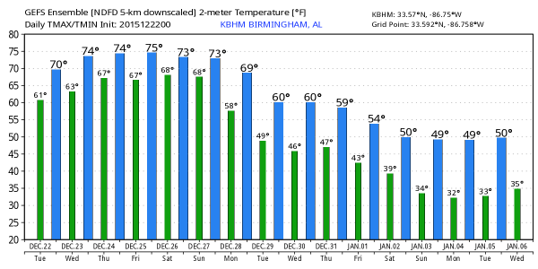
TODAY/TONIGHT: The radar is pretty quiet as the day begins; temperatures have been slow rising through the night, and we project a high in the low 70s this afternoon as the El Nino “blow torch” kicks in. You might see a glimpse of the sun at times, but the sky will be mostly cloudy. Expect showers to increase late this afternoon and tonight, but severe weather is not expected across the northern half of the state.
The guys at SPC (the Storm Prediction Center) do have the southern quarter of Alabama under a “marginal risk” of severe storms late today and tonight; that includes places like Mobile, Gulf Shores, and Dothan.
HIGH IMPACT SEVERE WEATHER EVENT POSSIBLE TOMORROW AFTERNOON AND TOMORROW NIGHT: Dewpoints surge into the 67-70 degree range tomorrow, wind fields increase, and a dynamic trough approaches from the west, setting the stage for potential trouble. Let’s go through the details.
TIMING: I think the core window for severe weather across Alabama will come from 3:00 p.m. tomorrow through 12:00 midnight tomorrow night. Understand there could be a few severe storms before 3:00 and after midnight, but that is the primary nine hour window. It is impossible to give you start/stop times for storms at any given location since they will be cellular and rather random. Just understand a severe storm is possible at any time during that threat window.
PLACEMENT: SPC has put parts of North and Northwest Alabama under an “enhanced” severe weather risk for tomorrow and tomorrow night, with the standard “slight” risk for the rest of the state.
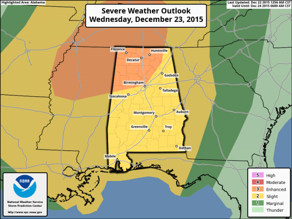
The best combination of instability and shear will be in that enhanced risk area, but please understand a severe storm is possible anywhere in Alabama. It doesn’t matter where you live.
Below is the projected STP (significant tornado parameter) valid at 6:00 p.m. tomorrow.

MODES OF SEVERE WEATHER: A few tornadoes are possible with the severe storms that form tomorrow afternoon and tomorrow night, with the higher probability of a tornado across the enhanced risk area. But, the threat of a tornado exists statewide, even near the coast. Also, storms will be capable of producing damaging winds, and some hail is possible.
RAIN: Rain amounts of 1-2 inches are likely between now and tomorrow night, probably not enough for major flooding problems, but localized issues could develop with the heavier storms.
CONFIDENCE LEVEL: Pretty high for this event. The one factor that could mitigate the risk is a big mass of rain and storms on the coast, which could block the inflow of moisture up into the northern part of Alabama, but no model is showing anything like that for now.
WILL THIS BE LIKE APRIL 27, 2011? I actually choose not to answer that question any more. Of course, the answer is no; April 27, 2011 was a generational event. But please understand this; if all we have is one tornado in the entire state, and if that one tornado happens to come down your street, then that day is YOUR April 27.
CALL TO ACTION: If you are reading this, then you are aware of the situation and stay informed. My concern is for those who don’t pay attention; please tell your friends and neighbors about this threat. So many people are traveling this time of the year, making it harder to reach the masses. And, please see this post on things you need to think about and do in preparation for tomorrow’s severe weather threat. It answers questions about how to get warnings, apps, live coverage, etc.
THURSDAY: We stay in a warm, moist environment, and SPC has a “marginal” severe weather risk up for much of the state, except for the Tennessee Valley. Storms Thursday could be strong to severe, but we do not expect any tornado threat. Main issue will be from strong straight line winds. Temperatures rise into the mid 70s; I don’t think we break the record high for December 24, 77 set in 1964, but we will be close.
CHRISTMAS DAY: We will be very close to the record high of 74, set in 1987. Mostly cloudy; a chance of showers will continue but nothing severe, and probably no thunder. See this for a history of Christmas warmth in Alabama.
THE WEEKEND: Still warm. Highs in the mid 70s Saturday and Sunday; more clouds than sun. And, the chance of a few showers, but nothing too widespread. But, to the west, a new storm takes shape that bears watching.
MORE STRONG STORMS? That system to the west will bring the chance of strong, maybe severe thunderstorms to Alabama again Sunday night into Monday; it is simply too early to determine the threat for now.
Cooler and drier air will follow by mid-week.
AT THE BEACH: Unsettled, warm weather continues through the weekend on the coast from Panama City Beach over to Gulf Shores… See the complete Gulf Coast 7 Day Planner here. The Gulf Coast Beach Forecast is presented by Gulf Shores Plantation by Mandoki Hospitality Vacation Rentals. Escape to Gulf Shores Plantation where memories last a lifetime.
WEATHER BRAINS: Don’t forget you can listen to our weekly 90 minute netcast anytime on the web, or on iTunes. This is the show all about weather featuring many familiar voices, including our meteorologists here at ABC 33/40. Scroll down for the show notes on the new episode we recorded last night.
CONNECT: You can find me on all of the major social networks…
Facebook
Twitter
Google Plus
Instagram
Look for the next Weather Xtreme video here by 4:00 this afternoon… enjoy the day!
Category: Alabama's Weather
About the Author (Author Profile)
James Spann is one of the most recognized and trusted television meteorologists in the industry. He holds the AMS CCM designation and television seals from the AMS and NWA. He is a past winner of the Broadcast Meteorologist of the Year from both professional organizations.Subscribe
If you enjoyed this article, subscribe to receive more just like it.


