Temperatures Heading Colder Again
After a wet start to Friday, the weather turned dry for the afternoon and evening with some fog especially across the southeastern quadrant of Alabama. Today will be a mostly sunny day with some clouds later in the day as the next weather system begins to get its act together.
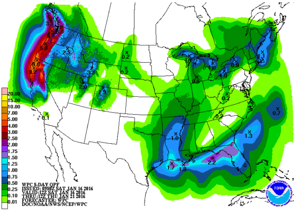
The trough located over western Texas this morning will move closer today with a surface low expected to develop in the Northwest Gulf of Mexico. That surface low will track eastward along the Gulf Coast tonight and early Sunday as the upper trough moves off into the Atlantic. While the Euro and the GFS are in close agreement on the timing and positioning of the surface low, there are still some differences in exactly how far north precipitation is likely to occur. So even though tonight’s forecast is close, there is still some uncertainty. Clouds will move back in this afternoon with a chance for some sprinkles or snow flurries tonight and early Sunday north of the Interstate 20 corridor. Rain will be more likely across South Alabama and the Florida Panhandle.
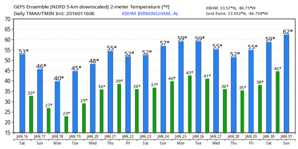
Temperatures are a bit tricky today. The front has moved well east of Alabama leaving about a ten degree temperature gradient across the state. Looks like temperatures across the Tennessee River Valley will probably not get out of the upper 40s today while much of Central Alabama should see the lower 50s.
The surface low tracks off the Southeast US coast on Sunday as a surface high over the Dakotas begins to slide southeast bringing another impressive shot of cold air to the Southeast US. Aloft, a fairly deep upper trough will dig into the eastern US for Monday. This pattern will result in another raw couple of days for Monday and Tuesday. Lows will dip into the 20s for Monday morning, struggle to reach 40 on Monday and then plummet on Tuesday with widespread lows in the teens. Sunshine Tuesday will help but the actual highs are only expected to reach the upper 30s.
Tuesday into Wednesday will be a transition period for us as we come under a ridge aloft as the trough moves off the eastern seaboard. The dry weather won’t last too long either as a fast moving short wave comes across the Lower Mississippi River Valley on Wednesday putting rain back into the forecast. While it will be rather cold Wednesday morning with lows in the lower 20s, we should see temperatures recover by afternoon with highs in the lower 50s. North of us in Tennessee and Kentucky, temperatures are not expected to recover as well so some light snow may occur in those areas.
Following right on the heels of the Wednesday trough will be another short wave that is forecast to close off over the Lower Mississippi River Valley with another surface low forming. This surface low is expected to be further north in Southeast Oklahoma or Northeast Texas, so any significant snow threat will be well north in the Ohio River Valley. Moisture returns Thursday and Friday, so we turn wet once again.
The rain should taper off from the west on Friday afternoon as the surface low moves into the Mid-Atlantic States. The upper flow does not go strongly northwesterly, so we won’t see the extremely cold air with this system but it will be a brief cool down for Sunday and Monday.
Looking into Week 2, also known as voodoo country, the pattern is expected to remain pretty active as it usually does this time of year. The GFS presents with yet another fairly low latitude upper low around the 26th of January with another, albeit weaker short wave around the 29th/30th. As we get set to enter February, yet another deep trough is forecast to dig into Texas promising another round of stormy weather.
I plan to have the next Weather Xtreme Video posted here by 7 am or so on Sunday morning. Be sure to check back here for future updates on the Alabama weather scene.
-Brian-
Category: Alabama's Weather


