Cold Air Arriving
The surface low that formed in the Northwest Gulf of Mexico yesterday scooted quickly eastward overnight spreading a little light rain across Central Alabama. The system spawned at least two tornadoes on the Florida West Coast in the vicinity of Bradenton and Sarasota that resulted in two deaths and four injuries. Picture courtesy of WFLA Tampa.

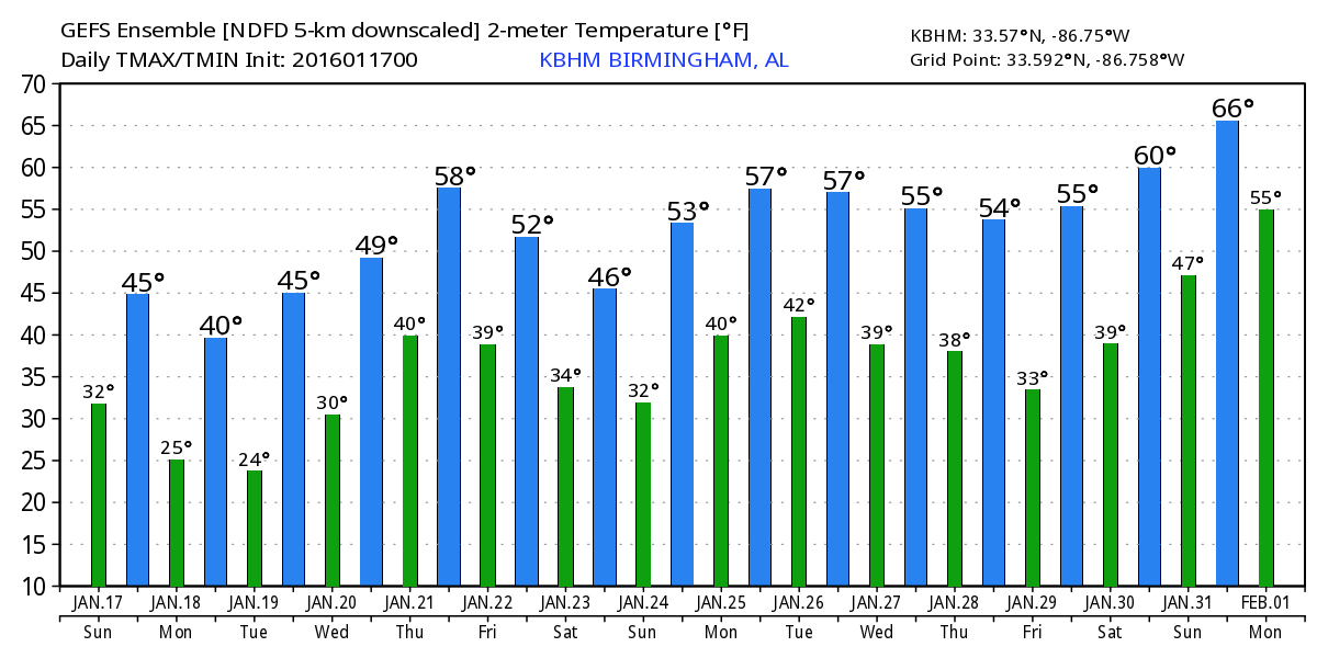
The upper trough was moving by Alabama this morning, so the upper flow will be turning to the northwest today as the surface flow goes northerly ushering in another round of cold weather. Highs today will not climb much with readings in the 40s. Clearing skies this afternoon should bring some sunshine for us to enjoy, but once the sun sets, the cold air advection will take over so that temperatures by sunrise Monday will be in the lower and middle 20s.
We’ll see a mixture of sun and clouds Monday but it will be a raw day with afternoon highs climbing only as high as the upper 30s. The coldest morning will come Tuesday as Central Alabama is expected to see morning lows in the upper teens, from 14 to 19. Tuesday we begin to transition out of the cold as the trough moves off the East Coast of the US and we come under ridging.
But then comes the wet weather. The surface flow late Tuesday and into Wednesday will come around to the south as the surface high moves to a position over North Florida. Increased moisture together with a developing upper low digging into the ARKLATX will increase rain chances Wednesday afternoon and evening and bring rain and storms to the Southeast US on Thursday. This far out it is difficult to be specific about the threat of severe weather, however, the strength of the surface system and the upper low along with the surge of warm, moist Gulf air northward into the Lower Mississippi River Valley suggests that there is some potential for severe storms. This will bear watching in future model runs.
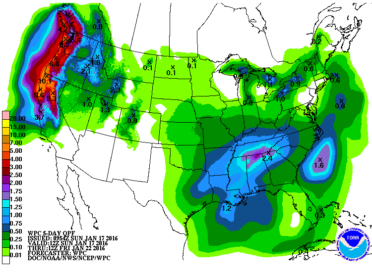
The upper trough moves by Alabama on Friday plunging us into another period of cold temperatures. This cold weather does not appear to be as cold as the weather pattern we are dealing with over the next several days. Interesting to note that the GFS and the Euro suggest the possibility of snow flurries on Friday as the surface low moves into the Mid Atlantic States bringing a cold northerly flow into Alabama along with some wraparound moisture. This pattern with wraparound moisture does not typically result in significant snow events for us, but as with the severe weather threat, we’ll have to keep a close watch on how this evolves.
With the surface system well northeast of us and the upper trough east of us, we turn cold just in time for the weekend, but at least it will be dry. Lows Saturday and Sunday will be below freezing once again, but not nearly as cold as Monday and Tuesday will be. Highs Friday and Saturday will be in the 40s with warmer temperatures for Sunday.
The weather pattern remains active, and it looks like that is not going to change anytime soon. Another short wave trough comes across the Central US on the 26th of January followed by another very deep trough over West Texas by the 30th. The deep trough over Texas could set up some very warm days for us as the sub-tropical jet could bring warmth to us from the Pacific.
Thanks for staying tuned to the Alabama Weather Blog. James Spann will have the next edition of the Weather Xtreme Video here first thing on Monday morning. Stay warm, enjoy the day, and Godspeed.
-Brian-
Category: Alabama's Weather
About the Author (Author Profile)
Brian Peters is one of the television meteorologists at ABC3340 in Birmingham and a retired NWS Warning Coordination Meteorologist. He handles the weekend Weather Xtreme Videos and forecast discussion and is the Webmaster for the popular WeatherBrains podcast.Subscribe
If you enjoyed this article, subscribe to receive more just like it.


