

Snow Showers/Flurries End This Evening
COLD NIGHT AHEAD: The weather across Alabama today behaved as expected; the most numerous snow showers have been over the northeast counties, where a few spots have measured over one inch. Marshall, Jackson, DeKalb, and Cherokee Counties remain under a “winter weather advisory” due to the potential for slick/icy spots…
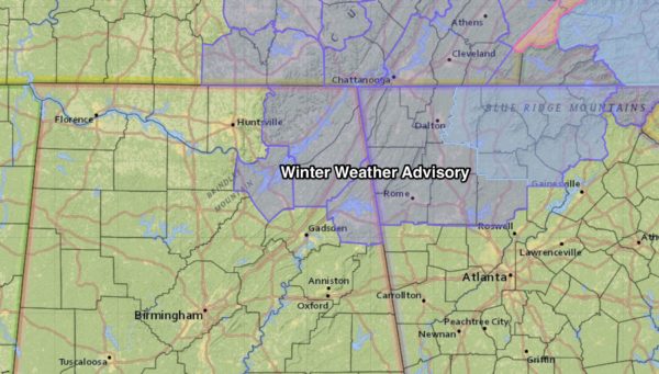
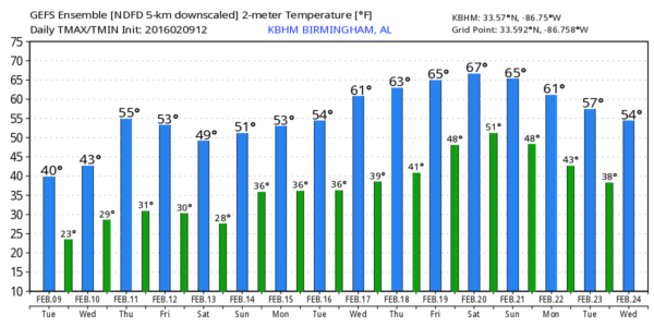
There has been basically no impact from the snow flurries for places like Birmingham, Anniston, Gadsden, and Tuscaloosa, as expected. Flurries and snow showers will end this evening across the state as the sky becomes clear. We drop into the low 20s early tomorrow, some of the colder pockets could see upper teens.
TOMORROW THROUGH FRIDAY: Cold air stays in place tomorrow; despite sunshine in full supply the high will be only in the low 40s. Then, we begin to warm Thursday with a high between 55 and 58 degrees along with a partly sunny sky.
A cold front will pass through Friday; it will bring scattered clouds, but it looks like the air will be too dry for any rain. The high Friday will drop back to near 50 degrees.
THE ALABAMA WEEKEND: Another surge of colder air will arrive just in time for the weekend. Expect a sunny sky Saturday and Sunday, but highs will be only in the 40s. And, the coldest morning will come early Sunday; most communities will see a low between 20 and 23 degrees, with upper teens for colder valleys and protected areas.
WINTER MISCHIEF MONDAY? The next wave will bring precipitation into the state Monday morning, and thermal profiles will be close to supporting an initial mix of freezing rain, sleet, and maybe a few snow flakes over parts of North Alabama. Understand there is absolutely no way to resolve details on a system like this six days away… it could be just a cold rain, or we could have some type of winter weather impact for the Monday morning commute over the northern third of the state. Just understand this possibility is on the table, and we will fine tune the forecast in coming days. But, for now, we will mention a “wintry mix” Monday morning, followed by rain Monday afternoon with a high in the 40s. Check out the Weather Xtreme video for all the maps, graphics, and more details.
WARMER DAYS: A pattern change is in the cards, and it sure looks like we will enjoy warmer weather in the February 17-24 period with highs well up into the 60s; we might even touch 70 degrees one afternoon.
WEATHER BRAINS: Don’t forget you can listen to our weekly 90 minute netcast anytime on the web, or on iTunes. This is the show all about weather featuring many familiar voices, including our meteorologists here at ABC 33/40.
CONNECT: You can find me on all of the major social networks…
Facebook
Twitter
Google Plus
Instagram
I had a great time today speaking to the students at Appalachian School in Blount County… be watching for them on the Pepsi KIDCAM today at 5:00 on ABC 33/40 News! The next Weather Xtreme video will be posted here by 7:00 a.m. tomorrow…
Category: Alabama's Weather
About the Author (Author Profile)
James Spann is one of the most recognized and trusted television meteorologists in the industry. He holds the AMS CCM designation and television seals from the AMS and NWA. He is a past winner of the Broadcast Meteorologist of the Year from both professional organizations.Subscribe
If you enjoyed this article, subscribe to receive more just like it.


