

Dry Through The Weekend; Still Cold Today
FRIGID MORNING: Here are some temperatures at daybreak across the great state of Alabama…
Black Creek (just northeast of Gadsden) 14
Millport 16
Russellville 16
Concord 17
Bessemer 18
Gadsden 18
Cullman 19
Valley Head 19
Centre 19
Haleyville 20
Jemison 20
Tuscaloosa 22
Anniston 22
Center Point 22
Lake View (Tuscaloosa County) 23
Birmingham Airport 24
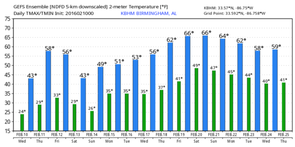
THE DAY AHEAD: Our weather will be cold, dry, and breezy today with a good supply of sunshine; we project a high in the low 40s for most communities this afternoon. Some places north of Birmingham will stay in the 30s all day.
TOMORROW/FRIDAY: The weather stays dry; we are forecasting a partly sunny sky both days with a high in the mid 50s. A cold front will pass through Friday afternoon in dry fashion.
COLDER FOR THE WEEKEND: Another surge of cold air arrives Friday night, and Saturday will be sunny but cold with a high only around 40 degrees along with a chilly north wind. We will drop down into the low 20s early Sunday, followed by a high in the mid 40s Sunday afternoon. The air stays dry, and the sky will remain mostly sunny. But, clouds will increase Sunday night.
WINTER ISSUES EARLY MONDAY? The next wave will bring precipitation into Alabama Monday morning, and there is still a window for a “wintry mix” over the northern third of our state as the day begins. However, there is great uncertainty as you might expect five days in advance. The GFS remains bullish on the idea of a short term mix of sleet, freezing rain, and maybe a few snow flakes, but the ECMWF (European) model is slower, and has trended warmer, with just rain on Monday for our state.
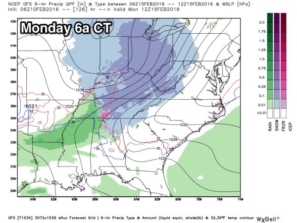
Just be aware of some potential for icy travel early Monday morning, otherwise the day looks cool and wet with periods of rain and a high in the 40s. We do note a cold air damming (CAD) pattern in place, and with colder air over North Georgia, that might open the door for some significant icing for parts of our neighboring state to the east. Check out the Weather Xtreme video for the maps, graphics, and more details.
REST OF NEXT WEEK: The upper air pattern begins to flip, and we should turn considerably warmer by mid to late week with afternoon highs rising into the 60s.
WEATHER BRAINS: Don’t forget you can listen to our weekly 90 minute netcast anytime on the web, or on iTunes. This is the show all about weather featuring many familiar voices, including our meteorologists here at ABC 33/40.
CONNECT: You can find me on all of the major social networks…
Facebook
Twitter
Google Plus
Instagram
I have a weather program this morning at Duck Springs Elementary in Etowah County… look for the next Weather Xtreme video here by 4:00 this afternoon. Enjoy the day!
Category: Alabama's Weather
About the Author (Author Profile)
James Spann is one of the most recognized and trusted television meteorologists in the industry. He holds the AMS CCM designation and television seals from the AMS and NWA. He is a past winner of the Broadcast Meteorologist of the Year from both professional organizations.Subscribe
If you enjoyed this article, subscribe to receive more just like it.


