Strong Storms Later Today
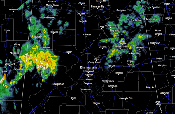
WET/STORMY MONDAY: Areas of rain and thunderstorms are moving through parts of North/Central Alabama at daybreak…
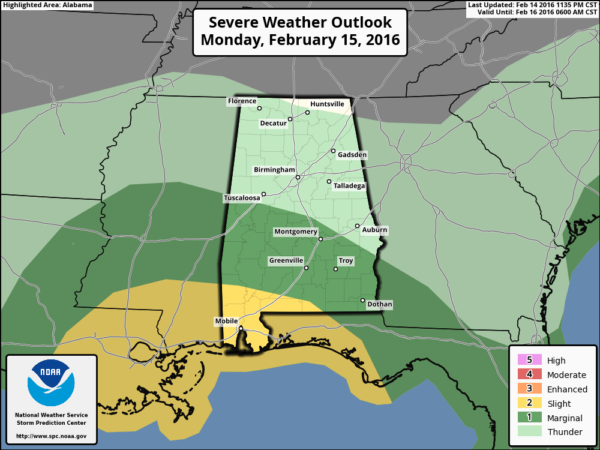
A dynamic storm system will keep us wet at times through tonight, and as the air becomes unstable over the southern half of the state, we will have to watch for strong to severe thunderstorms this afternoon. SPC has defined the standard “slight risk” of severe storms for Southwest Alabama, with a “marginal risk” as far north as Moundville, Wetumpka, and Eufaula.
As usual in the cold season, the main limiting factor will be the amount of surface based instability available. High resolution model data shows surface based CAPE values rising to over 1,000 k/jg in the broad zone from Demopolis down to Mobile and Gulf Shores by early afternoon. Wind fields and lapse rates are certainly supportive of severe storms in this area.
Keep an eye on dewpoints, and where they exceed 60 degrees today; that will be the highest severe weather threat.
TIMING: The core severe weather threat for the southern half of the state will come from 12:00 noon through 8:00 p.m.
MODES: Storms that become surface based over Central and South Alabama will be capable of producing hail, strong straight line winds, and a few tornadoes.
PLACEMENT: Highest concern will be in the broad area from near Linden down to Mobile and Gulf Shores, but a severe storm is possible just about anywhere south of a line from Moundville to Wetumpka to Eufaula, in the severe weather risk area defined by SPC. Severe storms are not expected north of I-20.
RAIN AMOUNTS: Totals of around one inch are likely for most communities through tonight; some spots could see a little more, but flooding is not expected to be a big issue.
Just be sure you have a way of hearing warnings today in case they are needed.
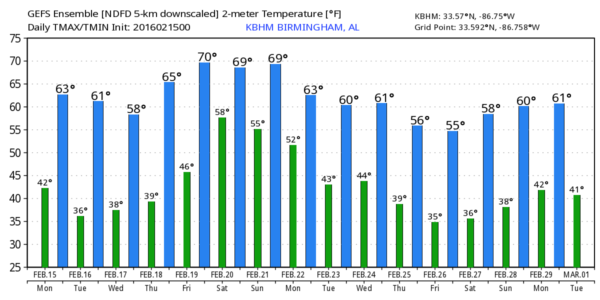
TOMORROW: It will be a generally dry day with a partly sunny sky and a high close to 60. A clipper will bring clouds to North Alabama late in the day, and it might squeeze out a few sprinkles, but the air over Alabama will be dry, and really significant rain is not expected.
WEDNESDAY THROUGH FRIDAY: No rain on these three days; the high Wednesday will be in the mid to upper 50s, but expect a very nice warm-up beyond that. We reach the mid 60s Thursday, and the high Friday will be close to 70 degrees. Lots of sunshine each day; some spring fever will probably break out by the end of the week.
THE ALABAMA WEEKEND: A weak front will drift down into North Alabama and stall; expect cloudy periods Saturday and Sunday along with the risk of scattered showers. I don’t think the rain will be widespread or heavy, however. And, we stay mild with highs between 67 and 70 degrees both days.
NEXT WEEK: The GFS is advertising a vigorous storm system around Wednesday February 24 that will need to be monitored for severe storm/heavy rain potential; see the Weather Xtreme video for maps, graphics, and more details.
WEATHER BRAINS: Don’t forget you can listen to our weekly 90 minute netcast anytime on the web, or on iTunes. This is the show all about weather featuring many familiar voices, including our meteorologists here at ABC 33/40. We will produce this week’s show tonight at 8:30 CT… you can watch online here.
CONNECT: You can find me on all of the major social networks…
Facebook
Twitter
Google Plus
Instagram
I have a program this morning at C.J. Donald Elementary in Fairfield… look for the next Weather Xtreme video here by 4:00 this afternoon. Enjoy the day!
Category: Alabama's Weather
About the Author (Author Profile)
James Spann is one of the most recognized and trusted television meteorologists in the industry. He holds the AMS CCM designation and television seals from the AMS and NWA. He is a past winner of the Broadcast Meteorologist of the Year from both professional organizations.Subscribe
If you enjoyed this article, subscribe to receive more just like it.


