Mostly Sunless Sunday
Let’s take a look at the Alabama weather situation on this Sunday afternoon, with an eye toward the severe weather threat looming Tuesday night into early Wednesday.
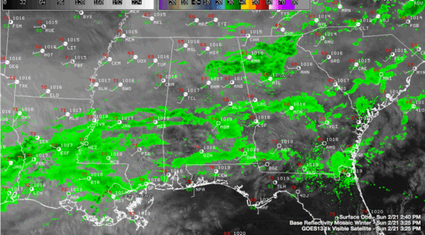
A persistent band of showers in the US-278 Corridor was mainly east of I-65 at mid-afternoon. This precipitation is the result of an upper level disturbance digging into the Ohio Valley and nudging a cold front southward. That front is just entering northwestern Tennessee at this hour.
There are a few showers across the US-80 Corridor as well.
Clouds are thick across the state of Alabama this afternoon. Along and north of US-278, things are socked in thick. South of there you might see an occasional patch of blue sky, but the key word is occasional. Temperatures are in the upper 60s to lower 70s in the I-20 Corridor. It is 74F in Montgomery, Evergreen and Mobile.
The showers have been slow to blossom across the state during the past 36 hours because of relatively dry air that is in place. Deeper moisture is heading into Alabama though and that will allow the showers to become more widespread tonight as that cold front to the north sinks into Alabama overnight.
The thinking is that the front will settle into the I-20 Corridor by early morning. Rain will be widespread during the day tomorrow night, lasting into Monday night. In the I-20 Corridor, you can expect about a quarter of an inch of rain overnight tonight with another three quarters of an inch on Monday. Greater amounts will fall to the south. There will be some thunder, but severe weather is not expected on Monday.
There will be a break in the action after midnight Monday night lasting into Tuesday morning. By then, a surface low will form over Texas and it will be strengthening rapidly, which makes it extra dangerous. The upper trough driving it will be taking on a negative tilt, indicative of a heightened severe weather risk. The airmass over Alabama will be marginally unstable upper level winds will be becoming more supportive of severe weather, and low level wind shear will be very strong. The result will be a risk of damaging winds and even tornadoes starting Tuesday afternoon and continuing Tuesday evening as a warm sector sets up over Alabama.
The low level winds will shift around to southwesterly after midnight, allowing the system to become one more capable of producing only damaging winds. This threat will accompany a line of storms that will move across the state Tuesday night and early Wednesday. Rain will end from the west Wednesday morning with falling temperatures through the day. There could be a few snow flurries Wednesday night into Thursday morning.
Category: Alabama's Weather, Severe Weather


