

Severe Storms Possible Tomorrow Night
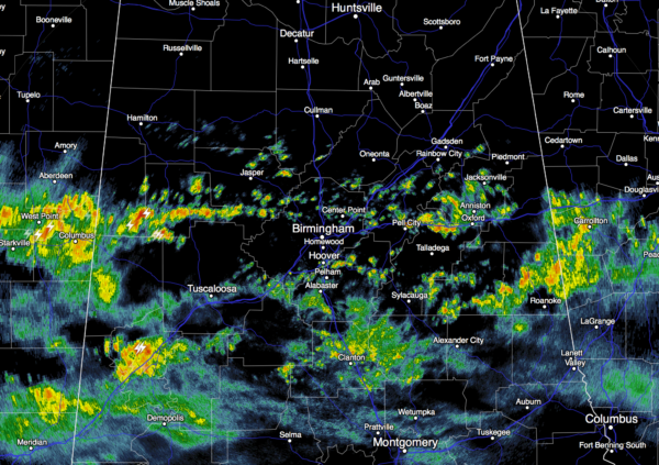
UNSETTLED WEATHER: A stalled front just to the north will keep the weather cloudy and wet at times through tonight; we will forecast occasional showers and thunderstorms. Showers are fairly widespread across Central Alabama at daybreak…
No severe weather is expected in Alabama through tonight, and the weather stays mild with temperatures holding in the 60s much of the day. A few spots could reach 70 degrees this afternoon.
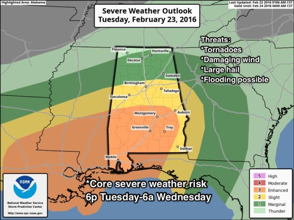
SEVERE WEATHER THREAT: A deepening surface low will move from north of Houston tomorrow, to near Nashville by Wednesday; it will be supported by a deep upper trough. This will bring the threat of strong to severe thunderstorms to the southern two-thirds of the state late tomorrow and tomorrow night.
As always in the cold season, the amount of instability is the big question. Best chance of seeing surface based CAPE values over 1,000 j/kg will come over the southern half of the state. All other parameters certainly suggest potential for severe storms; a low level jet of over 65 knots, bulk shear values (0-6 km) well over 50 knots, and rather steep lapse rates.
TIMING: The main threat of severe weather in Alabama will come from 6:00 p.m. tomorrow through 6:00 a.m. Wednesday. However, a few isolated severe storms could fire over West Alabama as early as 4:00 p.m. tomorrow.
PLACEMENT: The highest severe weather risk will come along and south of I-20, or for Tuscaloosa, Birmingham, Anniston, and points south. This is pretty much the northern border of the standard “slight risk”, as defined by the Storm Prediction Center. There is an “enhanced risk” of severe weather up for much of South Alabama, where instability values will be higher. A few severe storms can’t be ruled out across North Alabama, however, with a “marginal risk” up to Huntsville.
MODES: High resolution model data shows the storms will be more cellular in nature tomorrow night, certainly suggesting a tornado threat. Storms will also be capable of producing hail and damaging winds. While the core tornado threat will be in the “enhanced risk” over the southern half of the state, we can’t rule out a tornado as far north as I-20 (Tuscaloosa, Birmingham, Anniston).
RAIN: Amounts of 2-3 inches are possible between now and Wednesday morning across North/Central Alabama, so a few flooding problems can’t be ruled out.
CALL TO ACTION: Since this will be a nighttime event, be sure your NOAA Weather Radio has fresh backup batteries, and have a good warning app on your smart phone like WeatherRadio by WDT or MyWarn. Read this point on things to do before tomorrow night.
WEDNESDAY: Storms will end very early Wednesday morning, but clouds linger, and some light rain is possible during the day as cold air slips in from the north. Communities north of Birmingham won’t make it out of the 40s.
THURSDAY: The sky becomes partly sunny, and the weather stays cool with a high close to 50 degrees.
FRIDAY AND THE WEEKEND: Very nice weather; sunny days, clear nights, and a warming trend. We reach the mid 50s Friday, 60 Saturday, followed by mid 60s Sunday.
NEXT WEEK: A chance of showers will return early next week thanks to an approaching cold front; see the Weather Xtreme video for maps, graphics, and more details.
WEATHER BRAINS: Don’t forget you can listen to our weekly 90 minute netcast anytime on the web, or on iTunes. This is the show all about weather featuring many familiar voices, including our meteorologists here at ABC 33/40. We will produce this week’s show tonight at 8:30 CT… you can watch it live here.
CONNECT: You can find me on all of the major social networks…
Facebook
Twitter
Google Plus
Instagram
I have a weather program this morning at Haleyville Elementary School… be looking for the next Weather Xtreme video here by 4:00 this afternoon. Enjoy the day!
Category: Alabama's Weather
About the Author (Author Profile)
James Spann is one of the most recognized and trusted television meteorologists in the industry. He holds the AMS CCM designation and television seals from the AMS and NWA. He is a past winner of the Broadcast Meteorologist of the Year from both professional organizations.Subscribe
If you enjoyed this article, subscribe to receive more just like it.


