Severe Weather Likely Tonight
ACTIVE DAY: I encourage you to watch the Weather Xtreme video, which gives you all the maps and graphics that go along with this discussion.
THIS MORNING: No severe storms; mostly cloudy and mild with a shower or two possible, but nothing really widespread or heavy. Temperatures rise through the 60s; some places could touch 70 degrees this afternoon.
SEVERE STORMS TONIGHT: It is your typical cold season case of a system with excellent dynamics for severe thunderstorms, but somewhat marginal thermodynamics. No doubt the higher instability values will come over the southern half of the state, where surface based CAPE values should exceed 1,000 j/kg. We expect a low level jet (5,000 feet) of 60 knots or higher, bulk shear values (0-6 km) exceeding 75 knots in spots, and steep lapse rates.
A deepening surface low (under 1000 mb) will move to near Greenville, MS this evening, and then to a point just east of Memphis by midnight. The surface system will be supported by a deep upper trough.
TIMING: A few severe storms are possible near the Mississippi border as early as 4:00 this afternoon, but for most communities, the threat comes much later.
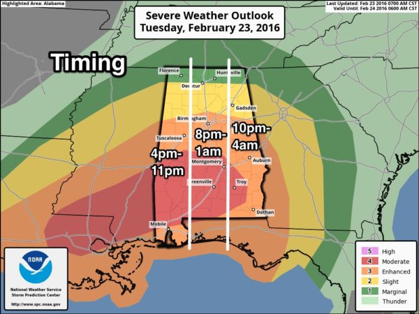
PLACEMENT: No doubt the highest tornado threat tonight will come over the southern two-thirds of Alabama, where SPC has defined “moderate” and “enhanced” risks. The threat of a tornado, while not zero, is much smaller north of I-20 across the northern part of the state.
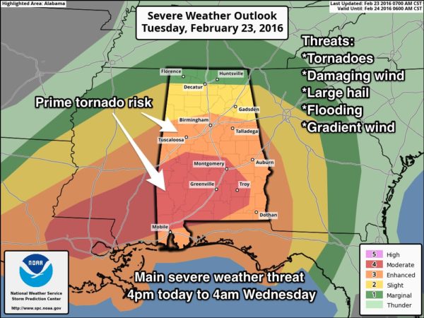
MODES: In addition to the threat of a tornado, storms tonight will be capable of producing damaging straight line winds and large hail.
GRADIENT WINDS: The tight pressure gradient around the deep surface low west of Alabama will bring very gusty winds to the state, not related to thunderstorms. These winds could gust as high as 35-40 mph, and that in itself could bring down some trees and power lines this afternoon and tonight. A wind advisory is in effect for most of the state.
FLOODING: A flash flood watch is in effect for much of North and Central Alabama; additional rain amounts of at least one inch are likely, and some flooding issues are possible, especially in the usual flood prone areas.
CALL TO ACTION: As always, be sure you have a way of hearing severe weather warnings. Be sure you have a properly programmed NOAA Weather Radio, and a good smart phone app designed for warnings, like WeatherRadio by WDT. Take some time to read this post about getting ready; it has some great information.
TOMORROW: It will be a windy, raw day with temperatures falling into the 40s, along with clouds and periods of light rain. There is even a risk of snow flurries tomorrow night and early Thursday over far North Alabama, but no impact is expected with surface temperatures generally above freezing.
The sky should become partly sunny during the day Thursday as drier air moves in; the high Thursday afternoon will be at or just over 50 degrees.
FRIDAY AND THE WEEKEND: Rain-free weather with sunny days, clear nights, and a warming trend. Friday’s high will be in the mid 50s… close to 60 Saturday, followed by mid 60s Sunday. We should mention mornings will be pretty chilly with a freeze likely for most places early Friday and Saturday.
NEXT WEEK: A cold front will bring a chance of showers back to the state Monday, and another rain event is likely by mid-week, late Wednesday and Thursday. See the Weather Xtreme video for more details.
WEATHER BRAINS: Don’t forget you can listen to our weekly 90 minute netcast anytime on the web, or on iTunes. This is the show all about weather featuring many familiar voices, including our meteorologists here at ABC 33/40.
CONNECT: You can find me on all of the major social networks…
Facebook
Twitter
Google Plus
Instagram
Look for frequent updates here on the blog today and tonight as the severe weather event begins to unfold…
Category: Alabama's Weather
About the Author (Author Profile)
James Spann is one of the most recognized and trusted television meteorologists in the industry. He holds the AMS CCM designation and television seals from the AMS and NWA. He is a past winner of the Broadcast Meteorologist of the Year from both professional organizations.Subscribe
If you enjoyed this article, subscribe to receive more just like it.


