Strong/Severe Storms Later Today
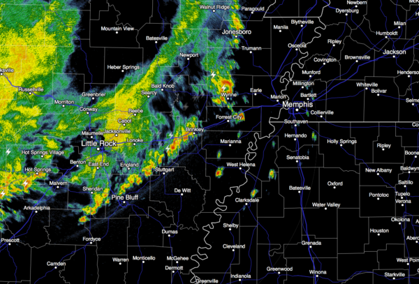
RADAR CHECK: Alabama is rain-free as this day begins, but we are watching a band of showers and storms moving through Arkansas; those will creep into our state later today.
Temperatures will rise into the low 70s again this afternoon, with a mix of sun and clouds. On the maps,a surface low will form north of the state, and it should be near Indianapolis by midday; this low is supported by an upper trough northwest of Alabama. This will set the stage for strong, possibly severe thunderstorms across our state this afternoon and early tonight.
The main limiting factor in the severe weather threat is the amount of surface based instability; surface dew points will have a hard time reaching 60 degrees, and the projected surface based CAPE values will be generally under 1,000 j/kg. But, other dynamic parameters suggest strong storms are very possible with a decent low level jet (50 knots), and a fair amount of shear (0-1 km storm relative helicity values over 200 m2/s2).
TIMING: A few storms could actually reach the northwest corner of the state around the lunch hour today, but the main window for severe storms will open around 2:00 over West Alabama, with the risk progressing to the east during the evening.
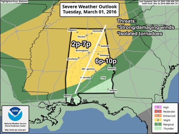
THREATS: The main risk comes from strong, perhaps damaging straight line winds. An isolated tornado is possible, but not especially likely. Some hail is possible from the stronger storms as well.
We note the higher tornado probabilities on the SPC outlook (5 percent) are well to the north of Alabama over Kentucky.
RAIN AMOUNTS: Amounts will be generally in the 1/2 inch range, not enough for flooding concerns.
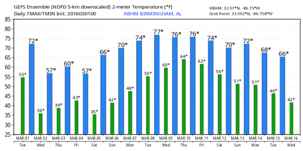
TOMORROW: It will be a cool/dry day with ample sunshine and a high in the mid 50s.
THURSDAY: A fast moving wave will bring showers back into the state; main window for rain comes from 12:00 noon to 10:00 p.m. No severe weather, probably no thunder, and rain amounts should be 1/2 inch or less.
FRIDAY THROUGH THE WEEKEND: Sunny days, clear nights, and a warming trend. We reach the upper 50s Friday, mid 60s Saturday, and the high Sunday will be in the 67-70 degree range.
NEXT WEEK: Medium range model data hints at a risk of strong, perhaps severe storms for the Deep South around Wednesday of next week…see the Weather Xtreme video for maps, graphics, and more details.
AT THE BEACH: There will be a risk of showers and storms late today and tonight, otherwise the weather looks pretty good through the rest of the week and the weekend from Gulf Shores over to Panama City Beach with a good supply of sunshine each day; highs will be around 70 by Friday and the weekend. See detailed beach weather on our Gulf Coast page here.
WEATHER BRAINS: Don’t forget you can listen to our weekly 90 minute netcast anytime on the web, or on iTunes. This is the show all about weather featuring many familiar voices, including our meteorologists here at ABC 33/40. Scroll down for the show notes on the new episode we recorded last night.
CONNECT: You can find me on all of the major social networks…
Facebook
Twitter
Google Plus
Instagram
I will be speaking to the senior adults at First Baptist Church of Tuscaloosa today… look for the next Weather Xtreme video here by 4:00 this afternoon (weather permitting!)… enjoy the day!
Category: Alabama's Weather
About the Author (Author Profile)
James Spann is one of the most recognized and trusted television meteorologists in the industry. He holds the AMS CCM designation and television seals from the AMS and NWA. He is a past winner of the Broadcast Meteorologist of the Year from both professional organizations.Subscribe
If you enjoyed this article, subscribe to receive more just like it.


