System Moving Faster; Timeline Moved Up
Click image to enlarge.
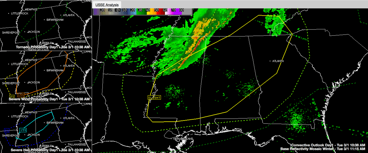
Here is a late morning look at the severe weather situation for Alabama:
HEADLINES
…Damaging winds and hail are a possibility across a large part of Central and North Alabama this afternoon and early evening as one or two lines of thunderstorms crosses the area.
…An isolated tornado is not out of the question, but is unlikely.
…The timing of the event has been sped up a bit, with the first storms into Marion County between 12-1 and Tuscaloosa/Birmingham perhaps as early as 2-3 p.m.
…The main activity should follow, reaching Hamilton around 4, and Birmingham/Tuscaloosa before 6 p.m.
HERE’S THE LATEST
…A fast moving, thin line of showers and storms is approaching the Northwest Corner of Alabama at this hour. It extends back to just east of Greenwood MS.
…None of the storms are severe for now.
…Ahead of the line, there are breaks in the clouds over eastern Mississippi and West Central Alabama. Unlike the last two systems, there aren’t powerful surface lows to pull large amounts of Gulf air northward, so moisture levels will be marginal. Dewpoints are in the middle 50s. Temperatures are warming through the middle 60s heading for highs in the lower 70s.
…CAPE values are in the 0-250 joules/kg range ahead of the line so far. CAPE values will be in the 250-500 joules/kg range ahead of the approaching storms. This is on the low side. Still capable of producing strong thunderstorm updrafts, but not enough for a significant severe weather outbreak.
…There is a little 90 knots wind max over western Mississippi that will spread across the northern half of Alabama this afternoon, increasing the bulk wind shear and helping to keep those thunderstorm updrafts from collapsing. This enhances the chance storms will be strong.
…Winds at 5,000 feet (850mb) will be pushing 40-50 knots, which does set the stage for damaging winds.
…The tornado threat will be low, with only moderate low level helicity and veering surface winds out of the southwest. This means very little low level wind contribution to rotation. Accordingly, the tornado probability is 2% through the entire SLIGHT risk area from the SPC. Earlier they had a 5% probability to the north over Kentucky. They pulled that out on their latest update.
…The SPC SLIGHT risk means short-lived and or not widespread isolated intense storms possible. Reports of damaging winds and hail larger than one inch will be possible. It covers about 70%of the state, between a line from Red Bay to Elkmont in North Alabama and a line from Mount Vernon to Castleberry to Troy to Phenix City. It includes the cities of Huntsville, Decatur, Scottsboro, Cullman, Hamilton, Jasper. Tuscaloosa, Birmingham, Gadsden, Anniston, Selma, Montgomery, Auburn and Monroeville.
TWO LINES EVENTUALLY
Right now there is a single line of storms…
…The line should be into Northwest Alabama within the hour.
…Hamilton between noon-1p.m.
…Cullman/Jasper between 1:30-2:30 p.m.
…Tuscaloosa/Birmingham/Gadsden between 2-3 p.m.
I think a second line forms back to the west in the vicinity of the cold front as the southern low approaching Little Rock. Look for another line of storms to push into Alabama, reaching…
…the Northwest corner of the state around 3 p.m.
…Hamilton before 4 p.m.
…Jasper/Cullman around 530 p.m.
…Tuscaloosa/Birmingham before 6 p.m.
…Gadsden around 630 p.m.
…Anniston before 7 p.m.
…Alex City around 8 p.m.
…Auburn around 930 p.m.
RAINFALL AMOUNTS should total between a quarter and one half inch with higher amounts over the Tennessee Valley.
Category: Alabama's Weather, Severe Weather
About the Author (Author Profile)
Bill Murray is the President of The Weather Factory. He is the site's official weather historian and a weekend forecaster. He also anchors the site's severe weather coverage. Bill Murray is the proud holder of National Weather Association Digital Seal #0001 @wxhistorianSubscribe
If you enjoyed this article, subscribe to receive more just like it.


