Is There a Severe Thunderstorm Watch in Our Future?
We continue to monitor for the potential for severe weather across Central Alabama on this Tuesday afternoon.
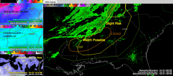
The band of showers and storms that started out over Arkansas this morning moved quickly east and sort of outran the cold front which is still back over northwestern Mississippi, waiting on a surface low south of Texarkana to move northeast.
Moderate to heavy showers were pushing into the western and northern parts of Jefferson County, around Sumiton and heading toward Warrior.
This activity will continue to weaken over the next hour or so and will not be severe.
But sunshine has allowed temperatures to rise into the upper 60s and lower 70s in a corridor generally along and south of I-20. Dewpoints are relatively low for severe weather, in the upper 50s. Surface based CAPE values are still meager, so storms are having a hard time holding it together.
But convection back in Mississippi near Okalona is beginning to show signs of getting going in an area that is closer to the cold front and getting some enhanced instability from colder air that is moving in aloft. At 18,000 feet, temperatures over Mississippi are some 3 degrees or so colder than over Alabama, and this is the source for some higher octane.
While the fall in temperature with height at the low levels is weak, it is really strong at the mid-levels, so any storms that fire over Central Mississippi will have the potential to produce large hail. This will translate eastward into Alabama through the afternoon and evening.
The amount of bulk shear has increased to over 60 knots over Northwest/West Central Alabama and Central Mississippi as well, so storms that
do form will be organized. There will even be supercells involved.
Damaging winds and large hail will be the main threats. Can’t rule out a tornado, but it would be very difficult for the atmosphere to conjure many, if any at all, across the area with the southwesterly surface winds.
SPC RISK
The new SPC severe weather outlook has trimmed the northern part of the slight risk area a bit. The risk is now south of a line from Aliceville to Jasper to Arab to Skyline.
SPECIAL NOTE
The NWS Birmingham is launching a special weather balloon right now to assess the situation aloft. We will report the data shortly.
Category: Alabama's Weather, Severe Weather


