Tuesday’s Warning Process
I thought I would go back and look at how the severe weather warning process worked yesterday in the case of the McCalla tornado, rated EF-2 by the NWS Birmingham. Four were injured, no fatalities.
When I worked for KDFW-TV in Dallas back in the 1980s, I loved hearing Al Moller speak; he was a meteorologist with the National Weather Service, a storm chaser, and had a remarkable grasp on severe local convective storms. One of his sayings I often repeat is this… “When it comes to thunderstorms, expect the unexpected”.
Most of us in the weather enterprise, didn’t expect an EF-2 tornado yesterday. Some severe weather, yes, but the main threat coming from gusty thunderstorm winds. Here is a timeline of the evening…
5:00: Storms begin to intensify, and in a broken line across North/Central Alabama.
5:25: The Storm Prediction Center issues a Severe Thunderstorm Watch.
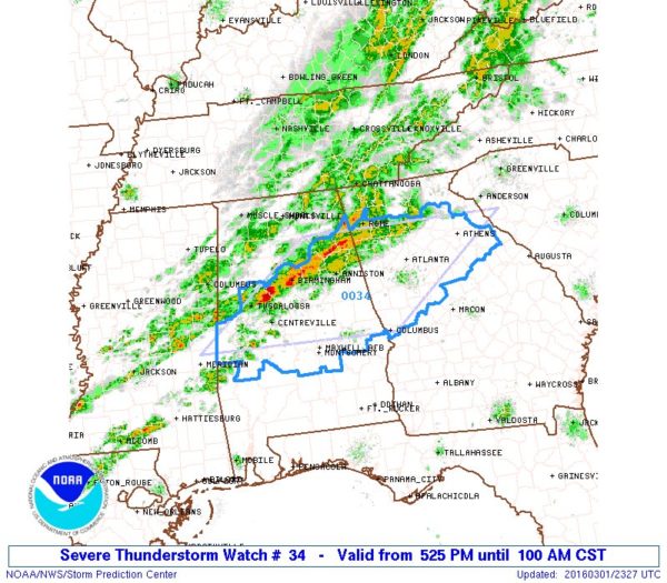
Why a Severe Thunderstorm Watch? NWS Birmingham explains…
“We are getting some questions as to why a tornado watch wasn’t issued instead of a severe thunderstorm watch. The primary threats for this event were straight line winds and hail. Even though a tornado or two occurred in the Birmingham area, these types of events do happen from time to time. We believe a tornado watch would have unnecessarily put a majority of AL under a widespread threat that didn’t exist. The atmosphere does play tricks at times, and tornadoes do occur, even under severe thunderstorm watches. This should also be a lesson to take severe thunderstorm watches and warnings seriously, not just tornado watches.”
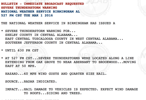
5:27: A severe thunderstorm warning is issued for parts of Jefferson, Shelby, and Tuscaloosa Counties as the intensification continues.
I used TV and social media to push the message aggressively…
Severe storm near McCalla will move into Shelby County with potential for winds of 50 mph #alwx pic.twitter.com/2A69tVreBi
— James Spann (@spann) March 1, 2016
5:44 A tornado warning is issued as a strong signature begins to show on radar…
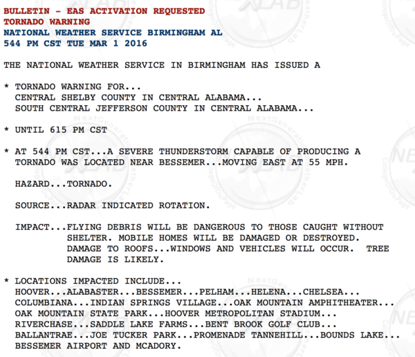
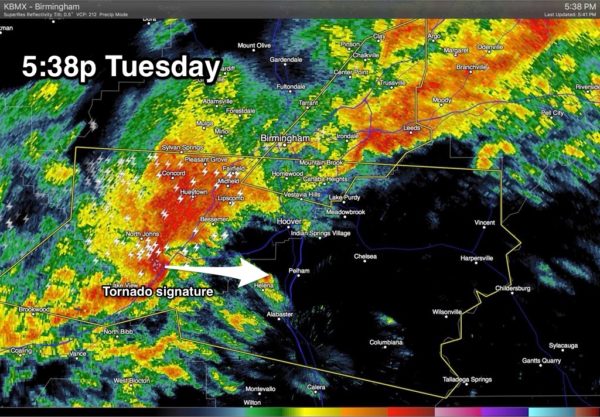
5:45: Damage begins in Bent Brook; the storm survey would reveal this was an EF-2 tornado.
THOUGHTS: It would be nice to promise 20-30 minutes lead time on every tornado, but that just isn’t possible. In yesterday’s case, the severe thunderstorm warning was issued 18 minutes before the damage started, and the tornado warning, only a minute in advance.
TAKEAWAYS….
*Take severe thunderstorm warnings seriously. They are issued for a reason, and you need to pay attention to them.
*You must be able to get tornado warnings within seconds of the time they are issued. Best ways are a NOAA Weather Radio, or a good smart phone app like WeatherRadio by WDT. And, most phones are enabled with WEA (wireless emergency alerts) capability which also sound for a tornado warning. NEVER rely on an outdoor warning siren. If you do, you don’t have much hope.
*Have a tornado plan put together, and rehearsed on sunny days, so you can implement that plan in seconds when a tornado warning is issued. You can get from the upstairs floor down to a small room on the lowest level in well under 60 seconds in most cases.
*If you get a tornado warning while driving, pull off at the first available place and go inside a store, gas station, restaurant, or any site built building. A car is the worst place to be during a tornado, and your smart phone will sound if you are in a tornado warning polygon.
I sure get the idea this might an active spring tornado season, so now is a good time to be thinking about how you get warnings, and your plan. We are so thankful we didn’t lose any lives yesterday.
Category: Alabama's Weather
About the Author (Author Profile)
James Spann is one of the most recognized and trusted television meteorologists in the industry. He holds the AMS CCM designation and television seals from the AMS and NWA. He is a past winner of the Broadcast Meteorologist of the Year from both professional organizations.Subscribe
If you enjoyed this article, subscribe to receive more just like it.


