

Flooding/Severe Weather Threat
VERY ACTIVE DAY: You will want to pay close attention to the weather over the next 24 hours as we have the dual threat of flash flooding and severe thunderstorms.
ROUND ONE: As expected, a large mass of rain, along with embedded thunderstorms, has moved into Alabama. The leading edge of the rain was moving into the Birmingham metro as I write this around 6:00; heavier rain is to the west over Northwest Alabama and East Mississippi. The chance of severe storms is very low this morning, but flooding is very possible in the heavier rain bands.
MIDDAY/EARLY AFTERNOON: The first batch of rain will move on to the east, and we will get a break in the rain during the middle of the day. The sun might even pop out briefly, and temperatures will rise to near 80 degrees in spots. With dew points in the 60s, this will make for a very unstable, volatile airmass by mid to late afternoon.
ROUND TWO: New storms could begin to form as early as mid-afternoon in the unstable air, and as dynamic support increases, we will have a risk of severe storms through tonight.
TIMING: We will focus on the 12 hour window from 4:00 p.m. until 4:00 a.m. A few strong/severe storms could begin earlier than 4:00 (you need to pay attention to warnings all through the day and tonight), but the better combination of dynamics and thermodynamics will come this evening into the nighttime hours.
PLACEMENT: SPC has defined an “enhanced risk” of severe weather for North Alabama, along and north of I-59 (Tuscaloosa to Birmingham to Gadsden), with the standard “slight risk” for the rest of the state. Highest tornado probabilities are in the enhanced risk, and a strong tornado is not out of the question there. But, understand a tornado is possible just about anywhere statewide tonight.
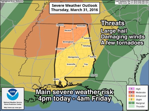
MODES: In addition to tornadoes, thunderstorms will also be capable of producing large hail and damaging straight line winds late today and tonight.
FLOODING: A flash flood watch remains in effect for just about the entire state through tonight; average rain amounts of 2-3 inches are likely, with isolated totals to 4 inches. This could create flash flooding.
CALL TO ACTION: Be sure you can hear severe weather watches and warnings, and know where you are going if you come under a tornado warning polygon. And, be sure and have a readiness kit in that “safe place”, including helmets. For additional information, including thoughts on apps for your phone, please see this post.
TOMORROW: The risk of severe storms will shift down into the southern half of the state, where SPC has defined the standard “slight risk”…
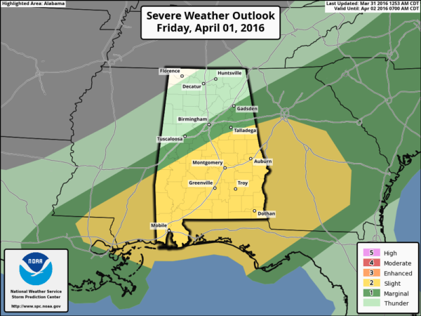
This is a low confidence forecast; the high resolution NAM model keeps a stalled surface front nearby, suggesting a risk of rain continuing, even for the northern counties of the state. We will adjust the forecast and mention a risk of showers through tomorrow, but the heavier rain and stronger storms should come over South Alabama.
THE ALABAMA WEEKEND: Sunny pleasant days, clear chilly nights. We project lows early Sunday in the 37-43 degree range, with potential for frost across colder valleys. Growers will need to monitor temperatures.
NEXT WEEK: Most of the week looks rain-free; the latest GFS (06Z run) develops a deep upper trough over the eastern U.S. by Thursday/Friday, and shows a freeze potential over North Alabama Friday morning April 8. This could change, of course, but something to watch for growers/gardeners. Remember, every year my advice is not to plant anything that might be harmed by frost or a freeze until after April 15. See the Weather Xtreme video for maps, graphics, and more details.
AT THE BEACH: Occasional showers and storms are likely through tomorrow from Gulf Shores over to Panama City Beach, but drier air returns for the weekend. See a very detailed Gulf Coast forecast here.
STORM SPOTTER TRAINING: Storm Spotter Xtreme is coming up Saturday, April 9 at the BJCC from 9am to 2pm. This will feature both the basic and advanced SKYWARN classes, along with a session from Kevin Laws of the Birmingham NWS office. And, if you come, you get free admission to the Alabama International Auto Show, going on at the BJCC that same day. There is no cost and no need to register. Just show up with a curious mind. Kids 10 and older will also enjoy this if they love weather and want to learn more. Please help us make the severe weather warning process better!
WEATHER BRAINS: Don’t forget you can listen to our weekly 90 minute netcast anytime on the web, or on iTunes. This is the show all about weather featuring many familiar voices, including our meteorologists here at ABC 33/40.
CONNECT: You can find me on all of the major social networks…
Facebook
Twitter
Google Plus
Instagram
Look for frequent updates here on the blog through the day and tonight as this event continues to unfold…
Category: Alabama's Weather
About the Author (Author Profile)
James Spann is one of the most recognized and trusted television meteorologists in the industry. He holds the AMS CCM designation and television seals from the AMS and NWA. He is a past winner of the Broadcast Meteorologist of the Year from both professional organizations.Subscribe
If you enjoyed this article, subscribe to receive more just like it.


