

Update On Wednesday’s Potential Severe Weather Event For Central Alabama
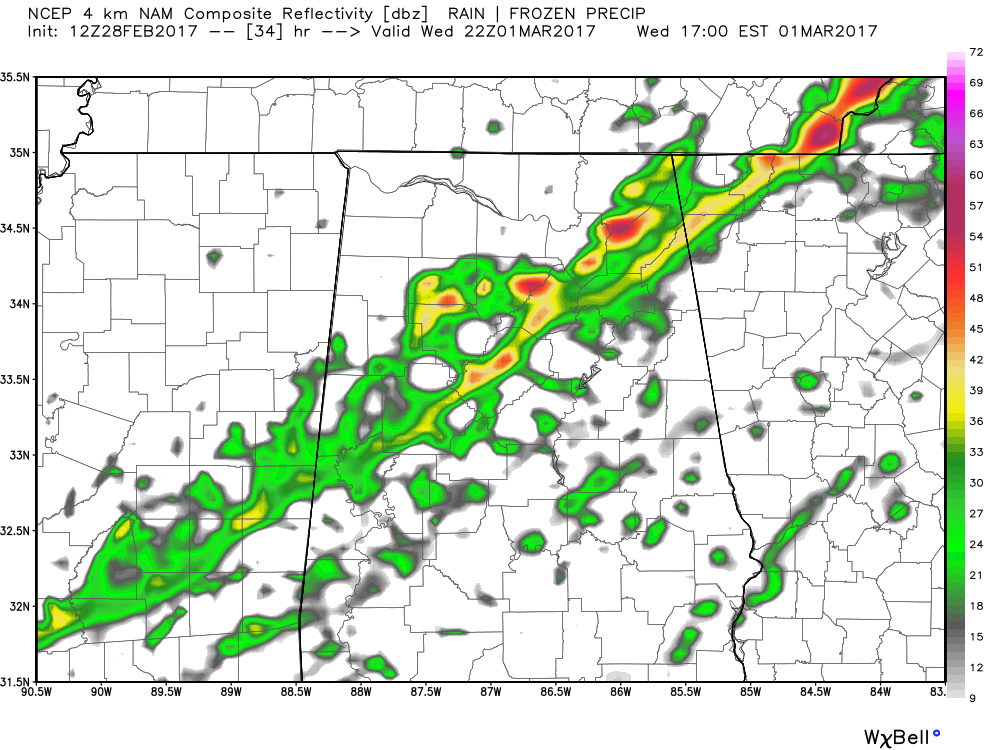
NAM-4k Simulated Radar at 4PM Wednesday
Alabama is facing an early season severe weather threat this week, just a week after Severe Weather Awareness Week in the state, so you should be up to date on your safety plan and terminology, and ready to RESPECT THE POLYGON. We will use this post until Wednesday as sort of a running blog to keep you updated on the unfolding threat.
TUESDAY MORNING 10AM UPDATE
Damaging winds continue to look to be the main threat with a squall line that will move through the area during the afternoon and evening hours, but an isolated tornado or two can’t be ruled out with any storms that manage to form ahead of the main line.
STRENGTH/PLACEMENT OF THE LOW
The global models (GFS and European) are in pretty close agreement with the location and strength in the surface low. The GFS has the low located over the western part of Michigan at 998 mb at 12AM on Wednesday morning. The European has a 997 mb low located just a little to the southwest from there, over northwestern Indiana, at the same time. Both are in agreement that the low will strengthen as it moves off in a general east-northeast direction. With the low being that far away from Central Alabama, that will keep the main dynamic support well to the north of us. We will still have to deal with strong upper-level winds even this far to the south of the low.
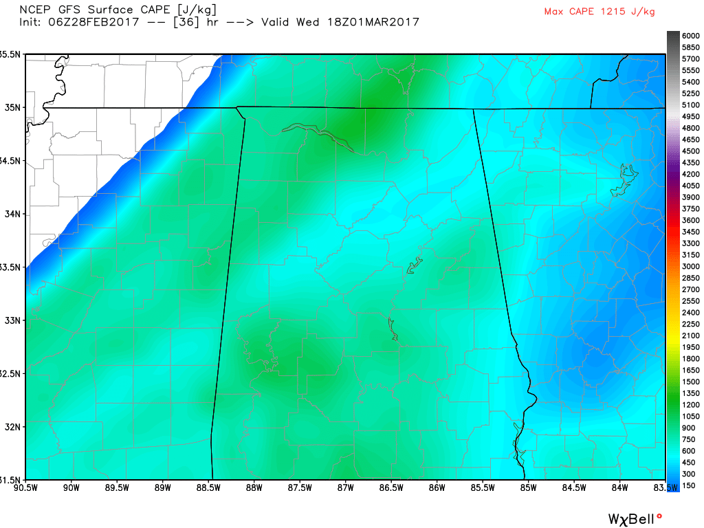
CAPE at 12PM Wednesday
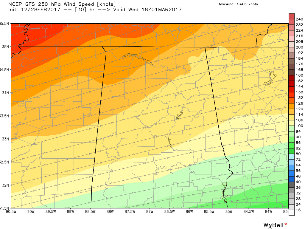
Upper Level Winds at 12PM Wednesday
SEVERE PARAMETERS
Instability: The GFS and European models are in good agreement with the values and the timing of the arrival of the front. The air mass over Central Alabama continues to look it will be ripe, with dewpoints in the 62º-67º range. CAPE values will be in the 500-1000 J/kg range across the state, with the higher values closer to the front in the northwestern part of the state.
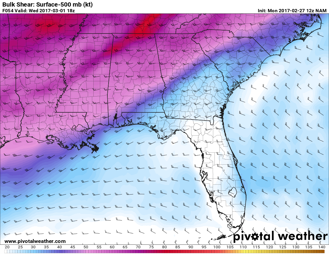
Wind Shear: Bulk shear values are showing 55-60 knots over Central Alabama at noon. This means that the storms will lean with height, and the downdrafts will not choke out the updrafts.
Upper level winds: At the 5000 ft level (850 mb), winds will be out of the west-southwest at 35-45 knots, and at 60-65 knots at 18,000 ft level (500 mb). The jet stream level winds (300 mb) will be around 100-110 knots. With the low and mid-level winds being this strong, this will increase the threat for damaging winds. The strong upper-level winds will enhance the exhaust from the storms and could lead to strengthening.
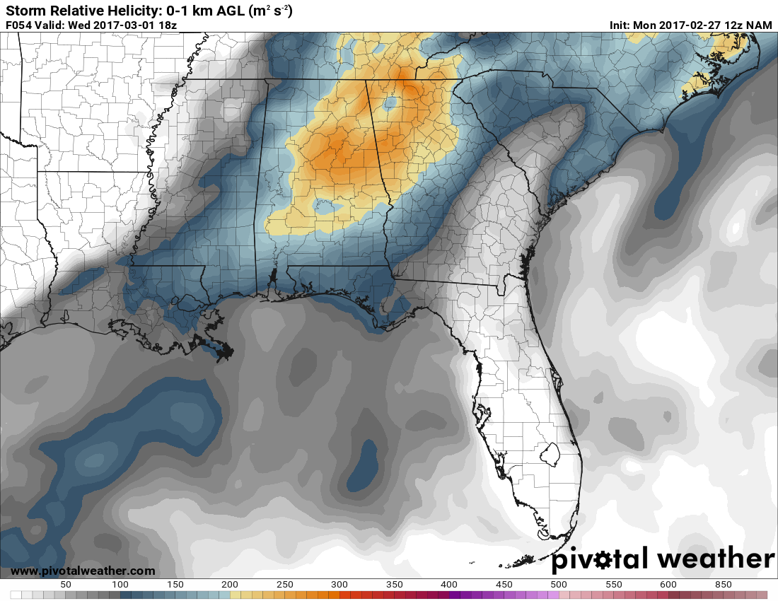
Low Level Helicity: With the winds being out of the southwest, and the surface low being so far away, tornado development is not favorable as it would be with southeasterly winds. Still, with 100-175 m2s2 helicity values, a few smaller tornadoes could be possible ahead of the main line.
All this tells us that the atmosphere will still be supportive of supercellular thunderstorm development and for the possibility of rotating updrafts. We will also have a strong wind field aloft along with steep mid-level lapse rates… supportive of hail.
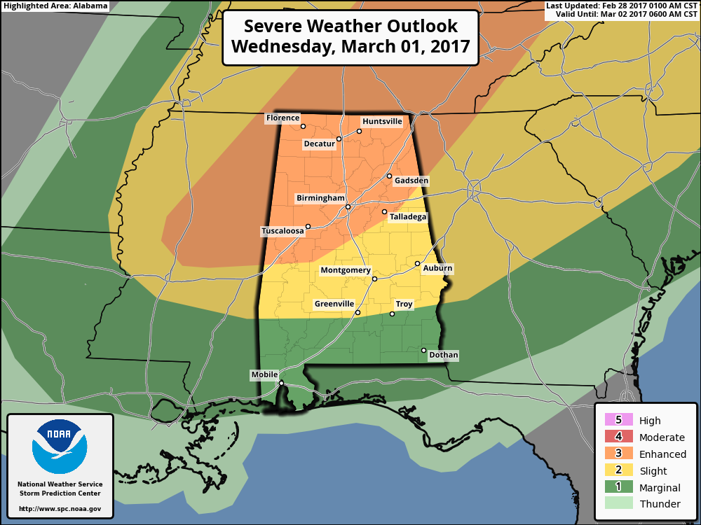
STORM PREDICTION CENTER
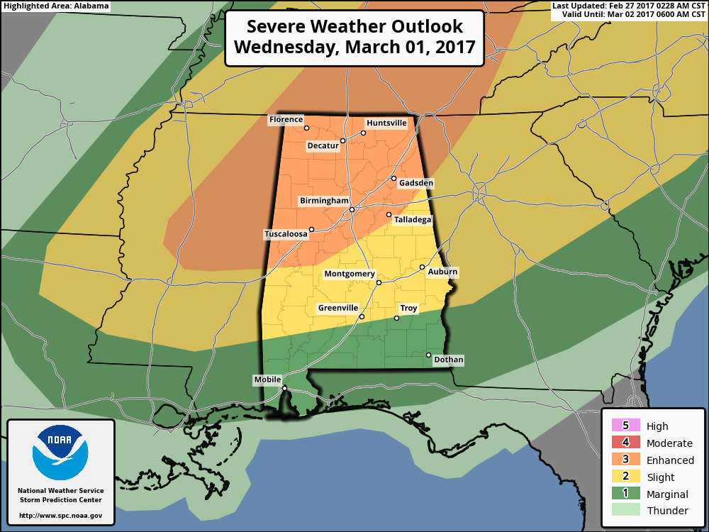
The latest update to the Day 2 Severe Weather Outlook from the SPC continues to have much of the northern half of the state in an “Enhanced Risk” for severe storms, with the rest of the northern ¾ of the state in the “Slight Risk.” South of that, a “Marginal Risk” stretches from Greenville and Troy south to the Gulf Coast.
TIMING
A line of storms ahead of the front will move into far Northwest Alabama around 12 noon, then moving southeast during the afternoon and evening hours. For places like Birmingham, Tuscaloosa, Anniston, and Gadsden, the core threat will come between 2PM and 6PM.
BOTTOM LINE
It continues to appear that the main threat for strong to severe storms will come from an organized line of storms associated with a cold front moving through the area during the afternoon and evening hours. Damaging straight-line thunderstorm winds and hail will be the main threats, but an isolated tornado or two are possible. A few storms could develop out ahead of the front of the main line, and could take on supercell characteristics. These could happen as early as noon.
As of now, we still believe that the better chance for supercell development, especially rotating storms, will be in the northwestern part of the state, up around Florence, Muscle Shoals, Russellville, Hamilton and Double Springs.
_____________________________________________________________
MONDAY MORNING 10 AM UPDATE
It looks like the severe weather threat for for Tuesday will be limited to far Northwest Alabama, with the main threat coming during the day into the evening hours on Wednesday. Damaging winds look to be the main threat with a squall line, but an isolated tornado or two can’t be ruled out with any storms that manage to form ahead of the main line.
MODEL COMPARISONS
There is basically good agreement between the two global models in terms of the evolution and timing of the event. The overnight runs of the GFS are a little bit faster than the European, with the European bringing the squall line into Northwest Alabama just before noon and into the I-59 Corridor around mid-afternoon Wednesday. The models are in decent agreement on the low pressure system.
STRENGTH/PLACEMENT OF THE LOW
Both global models have the low over eastern Michigan early Wednesday morning, moving rapidly to the northeast. Both have it around 996 mb but intensifying. The good news is that is pretty far away from us, so the dynamics should be well north of us as well. But there will still be strong upper level winds that we will deal with despite the distance to the low.
PARAMETERS
Instability: The European, being a little slower, has slightly higher instability values ahead of the squall line, which would of course lead to stronger thunderstorm updrafts. The air mass over Central Alabama will be ripe, as dewpoints will be in the 60º to 65º range. CAPE (instability) values will be at or around 1,000 J/kg, along with helicity values near 200 m2/s2.
Wind Shear: There will be plenty of speed wind shear, with 50-60 knots of bulk shear. This means that winds aloft will be substantially stronger than those closer to the surface, meaning the storms will lean with height. This means their downdrafts will not choke their updrafts.
Upper Level Winds: Winds at 5,000 feet will be 45-50 knots and 75 knots at 18,000 feet. Jet stream level winds will be around 110 knots. The strong lower and mid-level winds will make the damaging wind threat higher and the strong upper level winds will enhance the exhaust from the storms, making them potentially stronger.
Low Level Helicity: With the low so far away, low level winds will be out of the southwest, which is not as favorable for tornadoes as a southeast surface wind. Still, there will be 150-200 m2/s2 of low level helicity, a measure of spin in the atmosphere, which would be sufficient for a couple of less intense tornadoes ahead of the main line.
All this tells us that the atmosphere will be supportive of supercellular thunderstorm development and for rotating updrafts. We will also have a strong wind field aloft along with steep mid-level lapse rates… supportive of hail.
SPC
The Storm Prediction Center has areas generally along and north of the I-20 Corridor in an ENHANCED risk for Wednesday with a SLIGHT risk into South Alabama. The ENHANCED risk is just that, a one level upgrade above their basic severe weather forecast. Storm Prediction Center Severe Weather Outlook Categories Explained.
THIS JUST IN
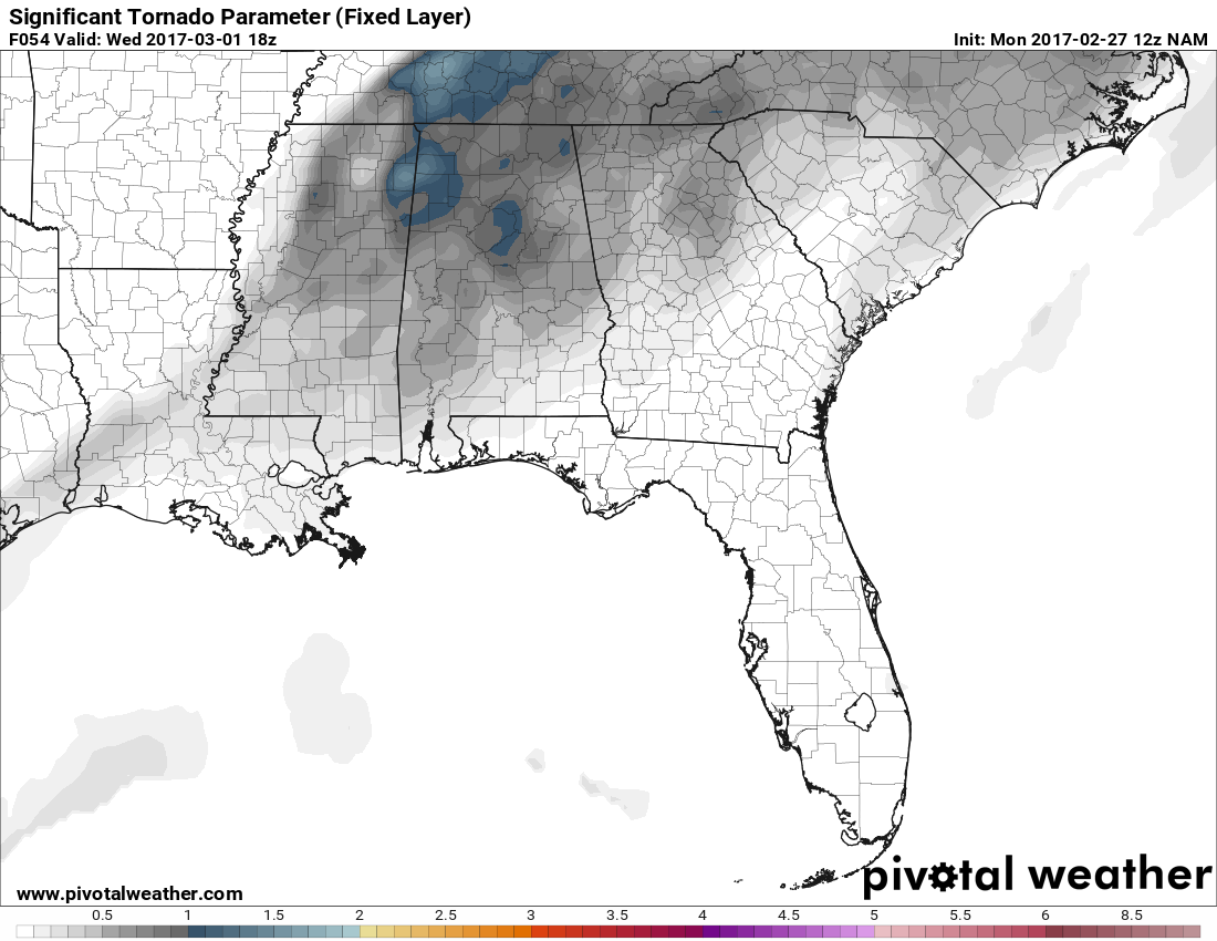
The latest run of the NAM for noon on Wednesday has STP values over 1 for much of northern Alabama, but the higher values are farther up north of the state.
Bulk shear values will be around 50 to 60 knots.
Storm relative helicity (0-1 km) values will be in the 200-275 m2/s2 range.
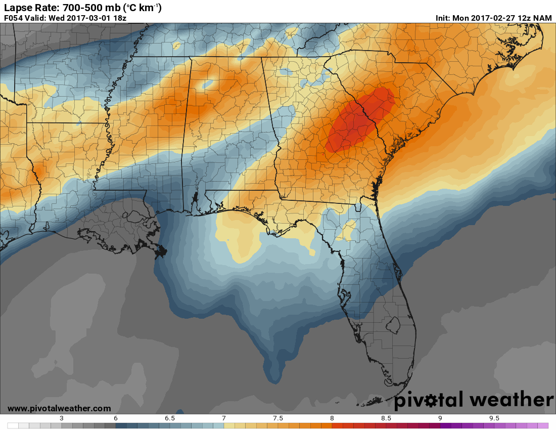
Lapse rates will be in the 6.1º to 7.0ºC km-1 range for much of Central Alabama, with higher values to the north.
And here is the latest GFS run valid at noon Wed
CAPE: 500-800 range
BULK SHEAR: 55-65 knots
SRH 0-3km: 100-150 m2/s2 for most, with values greater than 200 m2/s2 in east AL
SUPERCELL COMP: 1-2 for most, with 3 in the south-central part of the area
LAPSE RATES: 7.0ºC to 7.6ºC km-1 across the area
BOTTOM LINE
It looks like the main threat for strong to severe storms will come from an organized line of storms associated with a cold front will be moving through the area during the afternoon and evening hours. Damaging straight-line thunderstorm winds and hail will be the main threats, but an isolated tornado or two are possible. A few storms could develop out ahead of the front and the main line, and could take on supercell characteristics. These could happen as early as noon.
As of now, it appears that the better chance for supercell development, especially rotating storms, will be in the northwestern part of the state, up around Florence, Muscle Shoals, Russellville, Hamilton and Double Springs.
REVIEW YOUR SEVERE WEATHER SAFETY PLAN
It’s a Good Time to Check Your Severe Weather Safety Plan.
Respect the Polygon: The Difference Between Storm Based And County Based Warnings.
Category: Severe Weather
About the Author (Author Profile)
Scott Martin is an operational meteorologist, professional graphic artist, musician, husband, and father. Not only is Scott a member of the National Weather Association, but he is also the Central Alabama Chapter of the NWA president. Scott is also the co-founder of Racecast Weather, which provides forecasts for many racing series across the USA. He also supplies forecasts for the BassMaster Elite Series events including the BassMaster Classic.Subscribe
If you enjoyed this article, subscribe to receive more just like it.


