Travel Concerns
An arctic cold front is passing east of I-65 as of 10 AM, and another batch of cold air is coming into Alabama. The good news is that this will help dry the standing water where ice is melting; the bad news is any leftover water or ice on roads tonight will freeze even harder by tomorrow morning.
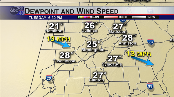
The breeze and falling dewpoints (drier air) will do a good job of drying off some of our highways. Below is RPM model output for this evening (dewpoint and wind speed). The lower the dewpoint and stronger the breeze, the more evaporation you will see. Temperatures will be in the lower 30s this evening as dewpoints fall into the twenties.
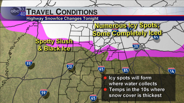
Much of the Tennessee Valley and the ridges of eastern Alabama (including parts of Jefferson and St. Clair Counties) may still have a large amount of road icing through Wednesday morning. Since temperatures will fall down into the 10s and 20s, any standing water left outside the estimated areas below will still freeze into black ice! Do not assume that every road and bridge outside the pink and white areas will be completely ice-free. Tomorrow’s sunshine will help melt more, and by Thursday all of the Birmingham metro area should be ice-free; Cullman, Gadsden, Huntsville and areas where more than 6 inches of snow and ice accumulated may still have some lingering issues through Friday morning unless a LOT of melting and evaporating occurs on Wednesday and Thursday.
It is always very helpful when you tell us how roads are in your area; we cannot see it all with cameras and weather instruments. One of the best ways to report weather/road conditions is via Twitter; use the hashtag #alwx in your tweet with your location and what you see.
-Jason
Follow me on Twitter: @simpson3340
Category: Alabama's Weather


