

The wedge
Cold-air damming, more commonly known as a “wedge”, is one of the most interesting phenomena in dynamic meteorology to me. It only happens a few times a year, but when it does it presents big forecast challenges.
The wedge occurs when a ridge of high pressure sets up near the east coast of the U.S., east of the Appalachians. Air normally flows clockwise around a high pressure area, when the wind is in balance. But, if the air is cool and stable, the air flowing around the south side of the high (from the east) can’t make it over the Appalchians. Balance no longer exists, and air begins to flow directly from high to low pressure, instead of clockwise. Therefore, cold air gets trapped on the east side of the mountains, and flows rapidly southwest. The heavy, cold air actually enhances the high pressure ridge east of the mountains. So, air from the Northeast U.S. gets an express to the Southeast.
Take a look at the isobars of constant pressure and the winds this morning. Notice that the winds are blowing perpendicular to the isobars, from high to low pressure, instead of parallel to them like they normally do. This is because of the blocking by the Appalachian mountains.

Below is a loop of the surface temperatures over the past 24 hours. Notice how the cold air just slowly spreads SW east of the mountains in the Carolinas, Georgia, and east Alabama, then once the mountains “end” south of BHM, the wedge dissipates. (The color table changes some in the image, sorry about that. It actually makes the cold air moving in look weaker than it is).
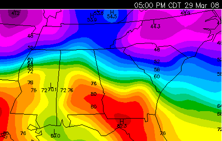
Wow. 40s in Georgia, 80s in Mississippi.
Another neat thing is that, since the Appalachians in NE Alabama and NW Georgia only average about 1500-2000 ft., the wedge doesn’t occur above that level. This sets up a temperature inversion, with cold air near the ground, but warm air above it. This causes ice storms sometimes in the winter. Below is a cross-section of temperature at 1 pm from Meridian to Atlanta. Notice the cold air wedge below 2000 ft.


Notice how, for example, in Anniston, the temperature is 44 just above the surface, but increases to 52 around 2000 ft., just above the mean elevation of the mountains.
Category: Met 101/Weather History
About the Author (Author Profile)
Subscribe
If you enjoyed this article, subscribe to receive more just like it.


