Complex Forecast Through The Weekend
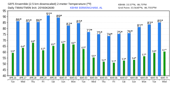
ANOTHER WARM DAY: Temperatures rise into the low to mid 80s across Alabama later today with a partly sunny sky. Moisture levels will increase a bit, and we note the high resolution HRRR model shows a few isolated, small showers across the northern half of the state this afternoon. We will amend the forecast to include the risk of a few showers this afternoon and into the evening hours, maybe even some thunder in spots. But, many communities will stay dry.
TO THE WEST: A major severe weather situation develops from southern Nebraska down into Texas; a “moderate risk” is defined for this zone, where storms late today and tonight could produce large hail, damaging winds, and tornadoes. A few violent, long track tornadoes are not out of the question based on the projected combination of instability and shear.
TONIGHT IN ALABAMA: A thunderstorm complex (MCS) will approach Alabama from the north, we will insert a risk of showers and storms for late tonight, mainly over the northern third of the state. These storms should be weakening and severe weather is not expected. The sky will be mostly fair for the southern two-thirds of the state tonight.
TOMORROW/THURSDAY: The big weather system over the Central U.S. will get closer, but a decent part of the day should be dry and warm; temperatures again will reach the 80s by afternoon. Any showers during the day will be few and far between, but showers and storms become more likely late tomorrow night into Thursday morning. We do note that SPC has pulled the standard “slight risk” of severe weather into the northwest corner of our state, with a “marginal risk” along and west of a line from Scottsboro to Clanton to Jackson…
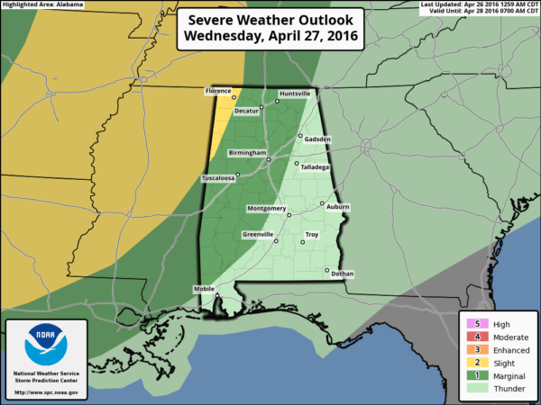
There should be a weakening trend as the storms move into Alabama, but some hail is possible along with gusty winds late tomorrow night into early Thursday. The main window for storms will be from about 12:00 midnight tomorrow night through 12:00 noon Thursday; rain amounts of around 1/2 inch are likely.
Drier air arrives Thursday afternoon with a clearing sky.
FRIDAY: For now the day looks warm and dry; with a good supply of sunshine we rise into the mid to upper 80s by afternoon… it should be one of the warmest days so far this year.
THE ALABAMA WEEKEND: Another spring storm system to the west will approach. We will need to mention the risk of a passing shower or storm Saturday, but it certainly won’t rain all day, and the sun should be out at times. Just about impossible to give you a specific time a shower or storm will pass through your neighborhood. Expect a high in the mid 80s Saturday afternoon.
Showers and storms become more widespread Sunday. And, models are a little more aggressive with the dynamic support, meaning we will have to watch for potential for strong, maybe severe thunderstorms by afternoon. In a complex pattern like this, there is no way we can resolve details now, but no doubt the day could very well be stormy at times.
NEXT WEEK: The latest GFS runs keep the weather unsettled Monday and Tuesday with a chance of showers and storms both days, followed by much cooler air over the latter half of the week. Looks like we will get a morning or two with lows down in the 40s; see the Weather Xtreme video for maps, graphics, and more details.
RACE WEEKEND AT TALLADEGA: Friday will be a beautiful day with a sunny sky, and afternoon temperatures well up into the 80s. Then, on Saturday, a passing shower or storm is certainly possible at the Superspeedway, but it won’t rain all day and they should get the Sparks Energy 300 in. The high Saturday afternoon will be in the mid 80s.
The weather Sunday will be more problematic as showers and storms become more widespread. Still, it won’t rain all day, and there is a chance the GEICO 500 will run, but just be ready for delays. Sunday’s high at the Superspeedway will be close to 80 degrees.
AT THE BEACH: Just a few widely scattered showers or storms tomorrow and Thursday, otherwise dry weather through Saturday with highs in the 70s on the immediate coast, with 80s inland. Showers and storms will arrive Sunday… See a very detailed Gulf Coast forecast here.
APRIL 27, 2011 ANNIVERSARY SPECIAL: Join us this evening at 6:00 on ABC 33/40 for a one hour special as we look back at the generational tornado outbreak of April 27, 2011 that killed 252 people in Alabama. You will see some very powerful stories.
WEATHER BRAINS: Don’t forget you can listen to our weekly 90 minute netcast anytime on the web, or on iTunes. This is the show all about weather featuring many familiar voices, including our meteorologists here at ABC 33/40. Scroll down for the show notes on the new episode we recorded last night.
CONNECT: You can find me on all of the major social networks…
Facebook
Twitter
Google Plus
Instagram
I will be speaking to the senior adults at First Baptist Church of Sylacauga today… look for the next Weather Xtreme video here by 4:00 this afternoon. Enjoy the day!
Category: Alabama's Weather
About the Author (Author Profile)
James Spann is one of the most recognized and trusted television meteorologists in the industry. He holds the AMS CCM designation and television seals from the AMS and NWA. He is a past winner of the Broadcast Meteorologist of the Year from both professional organizations.Subscribe
If you enjoyed this article, subscribe to receive more just like it.


