

Midday Nowcast: Warm and Dry for Us, Matthew’s Eye Moves Off of Haiti
A GREAT BUT HOT TUESDAY:
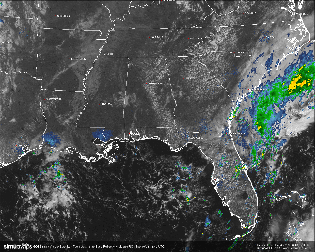
The main weather story today is Category 4 Hurricane Matthew making landfall in Haiti earlier this morning, and I’ll get to that a little later in the post. Conditions across Central Alabama at 11:30AM have temperatures warming nicely under a mostly clear sky across the area. Temperatures will continue to clime into the upper 80s for most of the area, with a few 90s out there. It will be hot, but with lower humidity levels and a nice southeasterly wind averaging 10 MPH, it really won’t feel all that bad out there. Skies will continue to be mostly clear, but we may have a few more clouds move in later this evening from the east. Unfortunately, it will be another dry day, with no rainfall expected in Central Alabama for at least the next 10 days.
AIR QUALITY ALERT TODAY:
Particulate Matter 2.5 levels will be high enough to raise the “Code Yellow” Air Quality Alert for the Birmingham metropolitan area today. Unusually sensitive people should consider limiting prolonged outdoor exertion.
TEMPERATURES ACROSS CENTRAL ALABAMA AT THIS HOUR:
Birmingham 82
Tuscaloosa 81
Gadsden 81
Anniston 82
Cullman 78
Alexander City 82
Auburn 82
Selma 81
Montgomery 84
NORMS AND RECS FOR TODAY IN BIRMINGHAM:
The normal high for October 4th is 79, while the normal low is 56. The record high for today was set back in 1925 at 92. The record low was set back in 1987 at 35.
TOMORROW’S FORECAST:
Sunny skies and slightly cooler temperatures across Central Alabama tomorrow with afternoon highs reaching the mid to upper 80s. Winds will mainly be out of the east averaging 5-10 MPH. Once again, it will be another day with no rain, and with low dew points and humidity levels, it will feel pretty comfortable out there.
HEADED TO THE BEACH:
Mostly sunny days, fair nights on the coast from Gulf Shores to Panama City Beach through most of next week, with highs generally in the 80s. Showers will be very hard to find. See a very detailed Gulf Coast forecast here.
BARBER VINTAGE MOTORCYCLE FESTIVAL:
This event runs from this Friday through Sunday at the Barber Motorsports Park. Highs in the low 80s Friday, but cooling into the upper 70s Saturday, and low 70s Sunday. Sunny days, clear nights. The weather could not be better. Get ticket information right here.
HURRICANE MATTHEW:
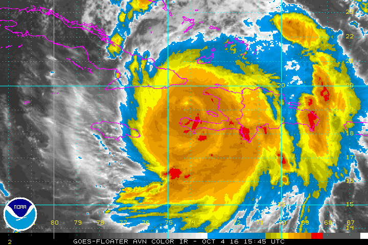
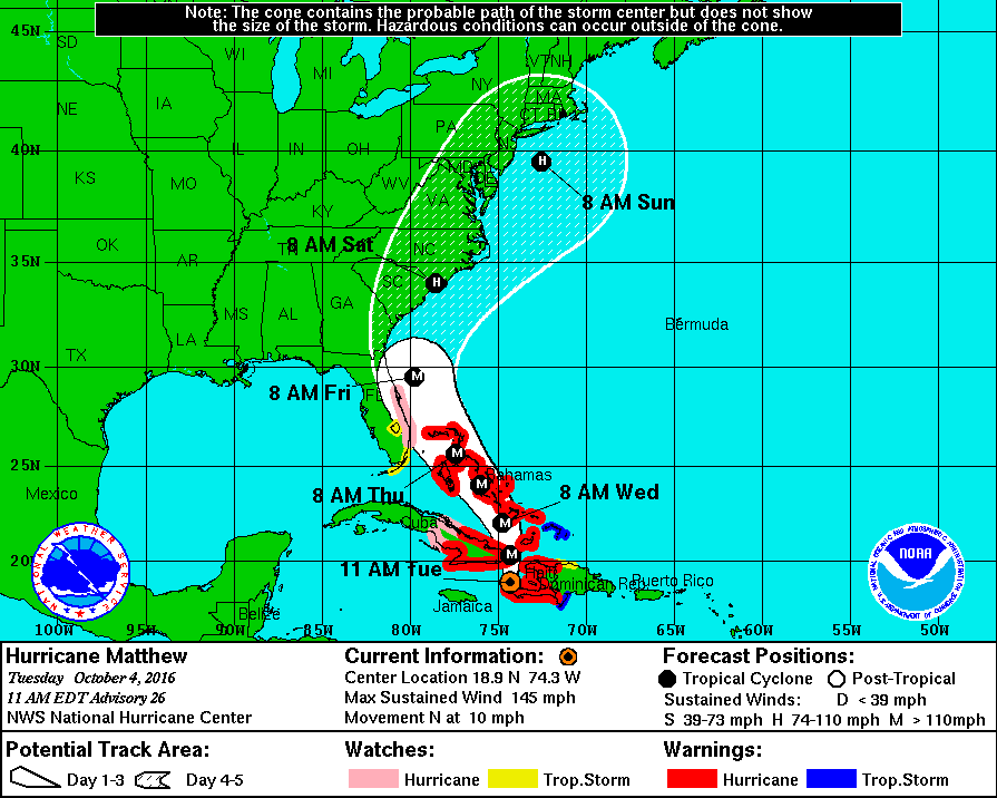
At the 11:00AM update from the National Hurricane Center, Matthew is still a category 4 hurricane with maximum sustained winds at 145 MPH. It is continuing to move to the north at 10 MPH and the eye has moved off of the northern shore of Haiti. Matthew is still on track to move up through the Bahamas during tomorrow and Thursday. There has been a slight jog to the west with the latest model runs and a U.S. landfall is possible near the North Carolina/South Carolina state line on Saturday morning as a possible category 2 hurricane, then re-emerges back over the ocean for a little while before another possible landfall somewhere near Boston on Sunday. Remember, expect surprises from tropical systems, so things could change. Stay in close touch with the latest updates and forecasts if you are close to the path of Matthew.
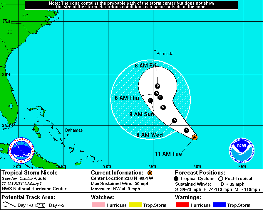
TROPICAL STORM NICOLE:
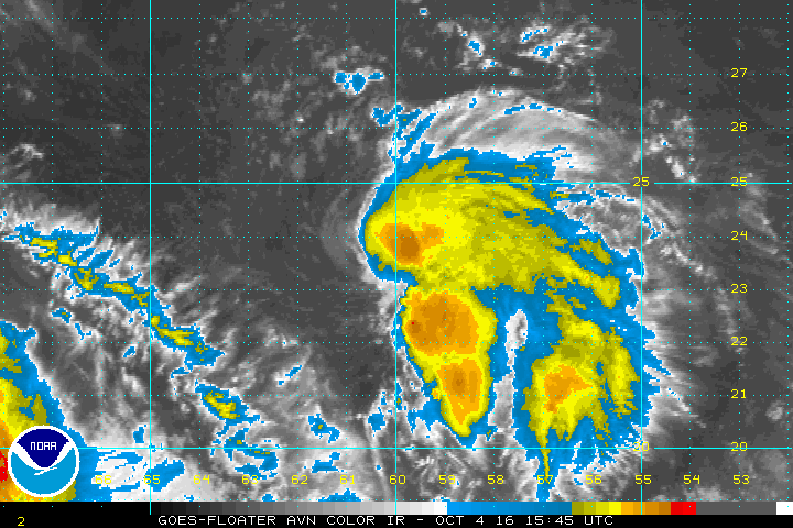
The tropical wave out in the Atlantic that the NHC has also been watching has developed a well-defined circulation and has been upgraded to Nicole. Maximum sustained winds at 11:00AM were at 50 MPH, and movement was to the northwest at 8 MPH. This storm is forecasted to move to the northwest until Thursday, staying well away from the mainland, then it will start to drift very slowly back to the south while weakening to a depression.
ON THIS DAY IN 1987:
A storm brought record snows to the northeastern U.S. Snowfall totals ranged up to 21 inches at North Springfield VT. It was the earliest snow of record for some locations. The storm claimed 17 lives in central New York State, injured 332 persons, and in Vermont caused seventeen million dollars damage. The six inch snow at Albany NY was their earliest measurable snow in 117 years of records.
THE BLOG IS ON TWITTER:
Be sure to follow the Alabama Wx Weather Blog on Twitter. Just click here to start following our feed.
WEATHERBRAINS:
This is the weekly netcast that’s all about weather featuring many familiar voices, including our meteorologists at ABC 33/40. You can listen anytime on the web, or on iTunes. You can find it here.
ADVERTISE WITH US:
Deliver your message to a highly engaged audience by advertising on the AlabamaWX.com website. The site enjoyed 10.2 MILLION pageviews in the past 12 months. Don’t miss out! We can customize a creative, flexible and affordable package that will suit your organization’s needs. Contact Bill Murray at (205) 687-0782.
Category: Alabama's Weather
About the Author (Author Profile)
Scott Martin is an operational meteorologist, professional graphic artist, musician, husband, and father. Not only is Scott a member of the National Weather Association, but he is also the Central Alabama Chapter of the NWA president. Scott is also the co-founder of Racecast Weather, which provides forecasts for many racing series across the USA. He also supplies forecasts for the BassMaster Elite Series events including the BassMaster Classic.Subscribe
If you enjoyed this article, subscribe to receive more just like it.


