

Alabama Stays Dry; Matthew Still Very Dangerous
NO RAIN FOR AT LEAST TEN MORE DAYS: Drought conditions across Alabama will continue to worsen through mid-October, as a dry pattern will continue. Mostly sunny days, fair nights through the weekend; highs hold in the 80s through Friday, but Matthew to the east will pull down much cooler air for the weekend. The high will drop into the mid 70s Saturday, and the latest GFS is printing a high of only 69 for Birmingham Sunday. A fresh north wind of 10-20 mph is likely over the weekend.
We note early morning lows will be well down in the 40s early Sunday and Monday, and colder pockets could visit the 30s for the first time this season. Maybe even a touch of light frost in a few spots across colder valleys and protected areas.
FOOTBALL WEATHER: Another delightful night for high school football games Friday night… clear with temperatures falling through the 60s.
Auburn will play at Mississippi State Saturday (11:00a CT kickoff)… the sky will be sunny with temperatures rising from 76 at kickoff, to near 80 degrees by the fourth quarter.
Alabama is also on the road; they play Arkansas at Fayetteville Saturday evening (6:00p CT kickoff)… a perfect evening for football with temperatures falling from 67 at kickoff into the 50s by the fourth quarter. The sky will be clear.
BARBER VINTAGE MOTORCYCLE FESTIVAL: This event runs from this Friday through Sunday at the Barber Motorsports Park. Highs in the mid 80s Friday, but cooling into the mid 70s Saturday, and upper 60s Sunday. Sunny days, clear nights. The weather could not be better. Get ticket information right here.
NEXT WEEK: Looking dry and pleasant with sunny days and clear nights; highs 77-83, lows mostly in the 50s. Remember, be extremely careful with any outdoor burning, and conserve water.
NICOLE FORMS: Tropical Storm Nicole is packing sustained winds of 50 mph in the Atlantic northeast of the Leeward Islands; this one should remain far from land, at least over the next five days.
MATTHEW STILL VERY DANGEROUS: Despite passing over the Tiburon Peninsula of Haiti this morning, sustained winds remain 145 mph, and the eye is very close to the eastern tip of Cuba. Not much change in the forecast track from NHC this afternoon…
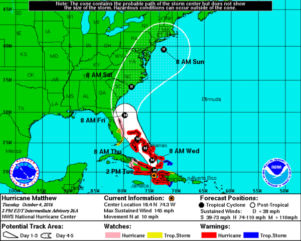
MATTHEW ANALOG: Concerning Hurricane Matthew and the impact on Florida… a good analog is Hurricane Floyd from 1999. The center of Floyd remained offshore (we expect the same type track from Matthew).
Although over a million Florida residents were evacuated before Floyd passed by, the state was only lightly affected. Strong waves and tropical storm-force winds did result in significant beach erosion on the east coast of Florida, as well as the loss of some boat piers. It also destroyed the Jacksonville Beach Pier.
But, Florida remained on the “good” west side of the circulation. Floyd had little impact on inland cities like Orlando. Matthew could produce a very similar impact, but we note the latest European global model run (the ECMWF) trended westward this morning, and if that verifies it could bring a much bigger impact to the Florida Atlantic coast.
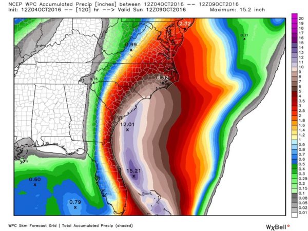
Floyd did the most damage in eastern North Carolina when it went inland around Cape Fear, and the same situation seems to be setting up for Hurricane Matthew.
ORLANDO/DISNEY WORLD: Matthew will pass east of there later late Thursday night and Friday. The good news is that the heaviest rain will be well east of Orlando, but conditions there will be pretty breezy Thursday night and Friday with occasional showers. Winds should be in the 20-30 mph range, with potential for higher gusts. But, the weekend will be beautiful with sunny days and fair nights. No need to evacuate, or change vacation plans.
ALABAMA: Not a drop of rain from Matthew, and the chance of rain for the next 10 days remains very low.
GULF COAST: Sunny days, fair nights on the coast from Panama City Beach to Gulf Shores through next week; showers will be very hard to find. Highs will be mostly in the 80s… See a very detailed Gulf Coast forecast here.
WEATHER BRAINS: Don’t forget you can listen to our weekly 90 minute netcast anytime on the web, or on iTunes. This is the show all about weather featuring many familiar voices, including our meteorologists here at ABC 33/40.
CONNECT: You can find me on all of the major social networks…
Facebook
Twitter
Google Plus
Instagram
I had a great time today visiting with the students at Leeds Primary School, and the 3rd grades at Cherokee Bend Elementary in Mountain Brook. Be sure and watch for them on the Pepsi KIDCAM today at 5:00 and 6:00 on ABC 33/40 News! The next Weather Xtreme video will be posted here by 7:00 a.m. tomorrow…
Category: Alabama's Weather
About the Author (Author Profile)
James Spann is one of the most recognized and trusted television meteorologists in the industry. He holds the AMS CCM designation and television seals from the AMS and NWA. He is a past winner of the Broadcast Meteorologist of the Year from both professional organizations.Subscribe
If you enjoyed this article, subscribe to receive more just like it.


