Long Dry Spell Continues; Matthew Closer To Florida
THE ALABAMA DROUGHT: Let’s say up front there is simply no significant chance of rain for most of Alabama for the next ten days. This will be the 17th consecutive day with no rain at Birmingham (based on data at the airport), and that string could very well go out to 30 days based on the pattern we are seeing for the rest of the month.
Drought conditions will worsen; be extremely careful if you are doing any outdoor burning, and conserve water. The rains will return in November and December; October is usually our driest month of the year.
TEMPERATURES: They stay above average through Friday, with highs in the 85-90 degree range. Nights will remain pleasant, however, with lows in the low to mid 60s.
THE WEEKEND: As you will see, there have been adjustments in the long range forecast track of Hurricane Matthew, and unfortunately the potential for a loop off the Florida coast has reduced the chance of it pulling down the coolest air so far this season, and we will need to revise temperature forecasts upward. We are now projecting a high in the mid 80s Saturday, followed by mid to upper 70s Sunday. The air stays dry, and the sky will rain mostly sunny both days.
FOOTBALL WEATHER: Another delightful night for high school football games Friday night… clear with temperatures falling through the 60s.
Auburn will play at Mississippi State Saturday (11:00a CT kickoff)… the sky will be sunny with temperatures rising from 78 at kickoff, to near 83 degrees by the fourth quarter.
Alabama is also on the road; they play Arkansas at Fayetteville Saturday evening (6:00p CT kickoff)… a perfect evening for football with temperatures falling from 67 at kickoff into the 50s by the fourth quarter. The sky will be clear.
BARBER VINTAGE MOTORCYCLE FESTIVAL: This event runs from this Friday through Sunday at the Barber Motorsports Park. Highs in the mid 80s Friday and Saturday, and upper 70s Sunday. Sunny days, clear nights. The weather could not be better. Get ticket information right here.
NEXT WEEK: Same story. Sunny days, fair nights. Highs in the low 80s, lows in the 50s, although 40s are likely Monday morning.
AT THE BEACH: Sunny days, fair nights, very few showers on the coast from Panama City Beach to Gulf Shores through most of next week with highs in the 80s. See a very detailed Gulf Coast forecast here.
MATTHEW: Sustained winds are down to 125 mph; the hurricane is moving north at 10 mph, and will impact the Bahamas today and tonight, where hurricane warnings are in effect.
The eye of Matthew will move dangerously close to the Florida Atlantic coast Friday. In a case like this, a small deviation one way or another will make a huge difference in the impact; a jog to the right will mean little damage and not much flooding, but one to the left could mean a significant threat to the coastal communities like West Palm Beach and Daytona Beach.
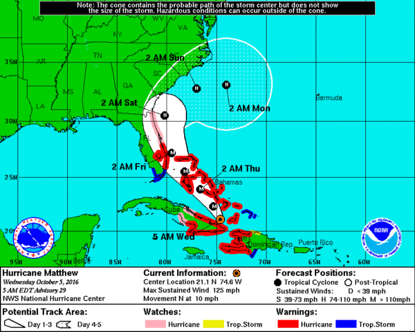
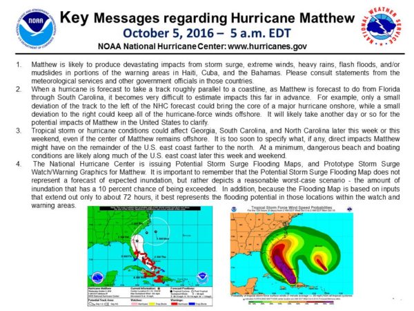
Beyond Friday, global models have changed their tune, now suggesting there could very well be a loop off the Florida coast this weekend and next week…
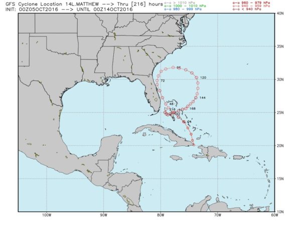
The idea of a hurricane looping and making a second threat to the Florida coast seems pretty outrageous, but crazy loops have happened before; Ivan in 2004, Ginny in 1983, Ginger in 1971, and Edna in 1960. (Thanks to Joe Bastardi for discovering those). Let’s point out there is hardly any skill in forecasting the placement and intensity of a tropical cyclone beyond five days, so we just can’t speculate on the final outcome now. But no doubt this will be a very interesting storm to watch.
The good news is that this potential loop scenario reduces any impact to the upper Atlantic coast and New England.
DISNEY WORLD: If you are planning a trip to Disney World in Orlando, I would not cancel my trip. And, if you are there now, I would not come home early. Orlando will see wind and some rain on Friday from Matthew as it passes to the east, but Disney is on the “good” west side of the system; no flooding or damage is likely. The weekend there should be very nice with a sunny sky Saturday and Sunday.
ALABAMA IMPACT: As noted above, not a drop of rain here from Matthew.
See the Weather Xtreme video for more maps and graphics.
WEATHER BRAINS: Don’t forget you can listen to our weekly 90 minute netcast anytime on the web, or on iTunes. This is the show all about weather featuring many familiar voices, including our meteorologists here at ABC 33/40.
CONNECT: You can find me on all of the major social networks…
Facebook
Twitter
Google Plus
Instagram
I will be doing a weather program this morning at Children’s of Alabama for patients and their families… look for the next Weather Xtreme video here by 4:00 this afternoon. Enjoy the day!
Category: Alabama's Weather
About the Author (Author Profile)
James Spann is one of the most recognized and trusted television meteorologists in the industry. He holds the AMS CCM designation and television seals from the AMS and NWA. He is a past winner of the Broadcast Meteorologist of the Year from both professional organizations.Subscribe
If you enjoyed this article, subscribe to receive more just like it.


