Midday Nowcast: Warm and Dry For Central AL Again Today
ANOTHER BEAUTIFUL AND DRY DAY:
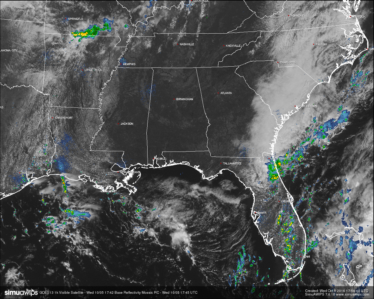
Crystal-clear skies are overhead above Central Alabama at the 1:00 PM hour, and temperatures have warmed nicely so far. Not a single drop of rain on radar anywhere near us at all. The closest rain to us is out to our west on the Missouri/Arkansas state line, and to our southeast around and just south of Jacksonville, Florida.
Today will be Birmingham’s 17th consecutive day without measurable rain, and with the way that the weather patterns are setting up according to the forecast models, it may stretch out to 30 days. Skies will continue to be mostly clear to clear, and afternoon highs will get up into the upper 80s for most of Central Alabama, with a few places touching 90 degrees.
AIR QUALITY ALERT TODAY:
Particulate Matter 2.5 levels will be high enough to raise the “Code Yellow” Air Quality Alert for the Birmingham metropolitan area today. Unusually sensitive people should consider limiting prolonged outdoor exertion.
TEMPERATURES ACROSS CENTRAL ALABAMA AT THIS HOUR:
Birmingham 84
Tuscaloosa 86
Gadsden 82
Anniston 82
Cullman 82
Alexander City 81
Auburn 81
Selma 82
Montgomery 82
NORMS AND RECS FOR TODAY IN BIRMINGHAM:
The normal high for October 5th is 79, while the normal low is 55. The record high for today was set back in 1927 at 94. The record low was set back in 1987 at 38.
TOMORROW’S FORECAST:
It will be a carbon copy of today’s weather… Sunshine will be out in full force with another day with no rain. Afternoon highs will be in the upper 80s for most, with a few places touching 90 degrees.
HEADED TO THE BEACH:
Sunny days, fair nights, very few showers on the coast from Panama City Beach to Gulf Shores through most of next week with highs in the 80s. See a very detailed Gulf Coast forecast here.
BARBER VINTAGE MOTORCYCLE FESTIVAL:
This event runs from this Friday through Sunday at the Barber Motorsports Park. Highs in the mid 80s Friday and Saturday, and upper 70s Sunday. Sunny days, clear nights. The weather could not be better. Get ticket information right here.
HURRICANE MATTHEW:
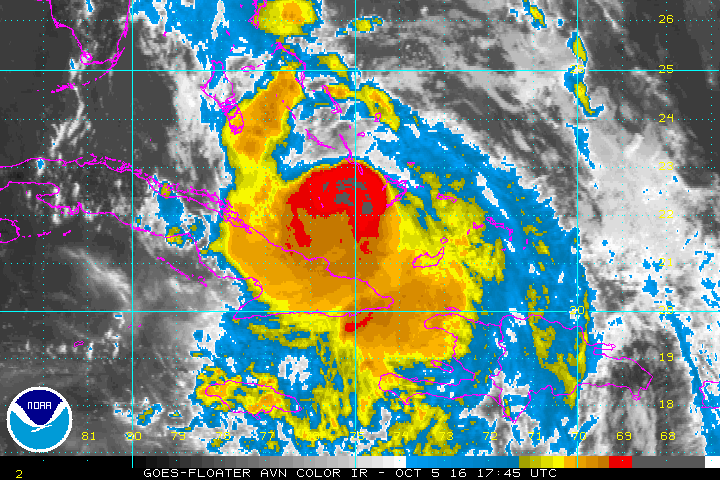
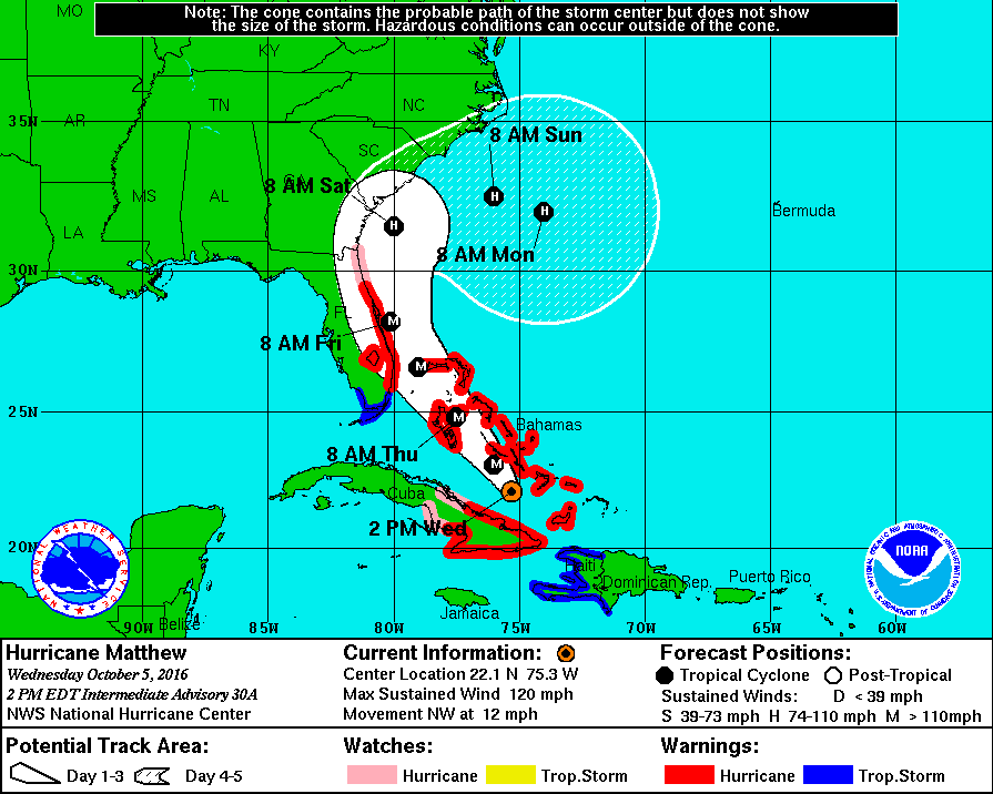
At 1:00 PM, the National Hurricane Center has Hurricane Matthew located about 70 miles north-northeast of Cabo Lucretia, Cuba, and about 70 miles south of Long Island, Bahamas. Maximum sustained winds are at 120 MPH, and current movement is at 12 MPH. Tropical storm warnings have been issued for the southern part of the Florida Peninsula and the keys, with hurricane warnings issued from Hollywood up to Daytona Beach. A hurricane watch has been issued for Daytona Beach to the Florida/Georgia state line.
The official track has the center riding parallel to the coastline of Florida and possibly making landfall around Cape Canaveral on Friday morning before making a turn away from land. With this course, tropical storm and hurricane conditions will occur along the east coast of Florida, Georgia, and the Carolinas. Just a small deviation in course can make a difference in storm surge and wind damage potential.
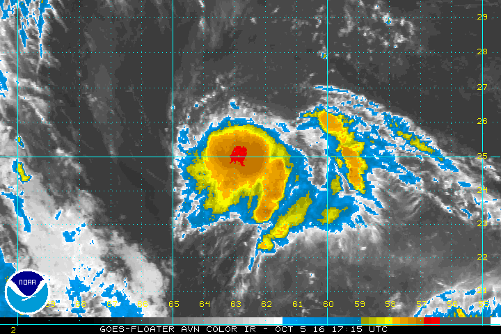
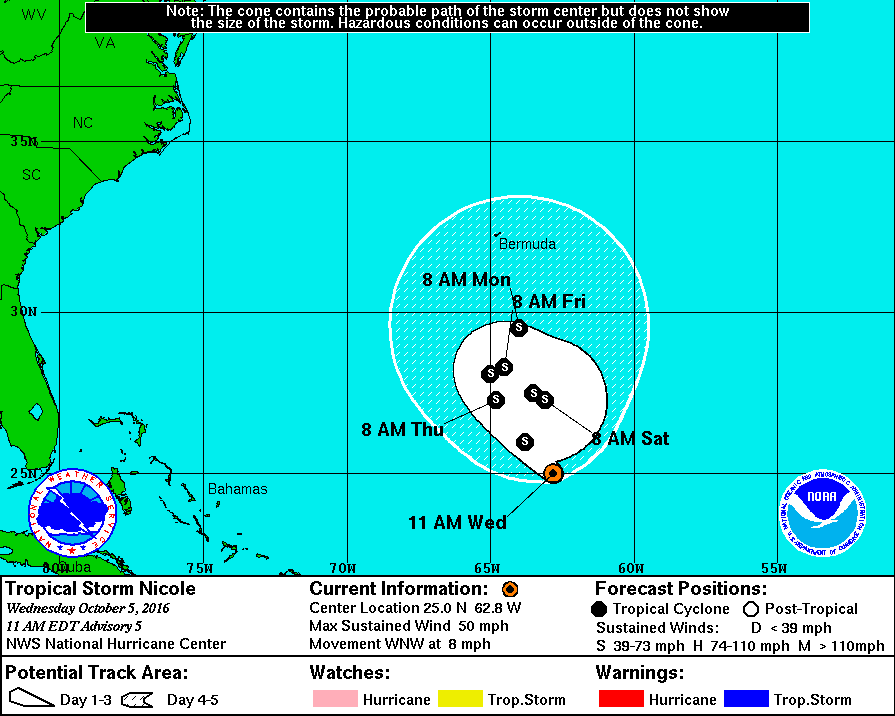
TROPICAL STORM NICOLE:
This tropical storm will pretty much meander around in nearly the same place out in the Atlantic Ocean south of Bermuda for the next five days, and continue at about the same strength with 50 MPH maximum sustained winds before beginning to weaken.
ON THIS DAY IN 1989:
Showers and thunderstorms associated with Tropical Storm Raymond deluged southeastern Arizona with heavy rain. Up to four and a half inches of rain was reported north of Wilcox. Three- fourths of the streets in the town of Wilcox were left under eighteen inches of water, and damage exceeded a million dollars. Evening thunderstorms developing along a cold front produced severe weather in Oklahoma and the Texas panhandle. Thunderstorms produced high winds which gusted to 80 mph at White Deer TX, and resulted in one death at Pocasset OK. Thunderstorms produced golf ball size hail at Pampa TX and Lefors TX.
THE BLOG IS ON TWITTER:
Be sure to follow the Alabama Wx Weather Blog on Twitter. Just click here to start following our feed.
WEATHERBRAINS:
This is the weekly netcast that’s all about weather featuring many familiar voices, including our meteorologists at ABC 33/40. You can listen anytime on the web, or on iTunes. You can find it here.
ADVERTISE WITH US:
Deliver your message to a highly engaged audience by advertising on the AlabamaWX.com website. The site enjoyed 10.2 MILLION pageviews in the past 12 months. Don’t miss out! We can customize a creative, flexible and affordable package that will suit your organization’s needs. Contact Bill Murray at (205) 687-0782.
Category: Alabama's Weather
About the Author (Author Profile)
Scott Martin is an operational meteorologist, professional graphic artist, musician, husband, and father. Not only is Scott a member of the National Weather Association, but he is also the Central Alabama Chapter of the NWA president. Scott is also the co-founder of Racecast Weather, which provides forecasts for many racing series across the USA. He also supplies forecasts for the BassMaster Elite Series events including the BassMaster Classic.Subscribe
If you enjoyed this article, subscribe to receive more just like it.


