Two Rounds Of Storms Ahead For Alabama
Here is a Sunday evening look at the active weather expected across Alabama this week. It comes in two rounds.
ROUND ONE: Scattered showers should begin to develop across Alabama tomorrow afternoon with rising moisture levels. We should also mention it will become windy, in fact the NWS Huntsville has issued a “high wind watch” for Madison, Marshall, Jackson, and DeKalb Counties for tomorrow afternoon and tomorrow night, where sustained winds across higher elevations (mainly above 1,000 feet) will increase to the 35-40 mph range, with gusts to 55 mph.
Rain and storms become widespread tomorrow night into Tuesday morning; the heaviest rain and stronger storms will come from 8:00 p.m. tomorrow through 8:00 a.m. Tuesday. SPC has roughly the western half of the state in a “marginal” severe weather risk for tomorrow night…
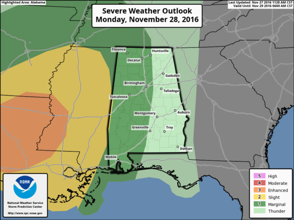
The main threat will come from strong straight line winds; the tornado threat is mainly confined to areas west of Alabama.
We will have a break from the rain for a decent part of the day Tuesday.
ROUND TWO: Rain and storms will increase again Tuesday night and Wednesday with an upper wave embedded in the southwest flow aloft. The main window for the most widespread rain will come from 8:00 p.m. Tuesday through 3:00 p.m. Wednesday.
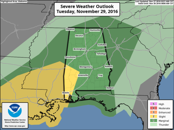
Determining the severe weather threat for “round two” is hard to do now; once “round one” is over we can get a better look at the atmospheric conditions. But, at the moment, it does look like we will have the risk of strong to severe storms Tuesday night into Wednesday morning. For now all of Alabama is in a “marginal” risk, with the standard risk defined for the southwest counties of the state…
The new 18Z model data just in shows the SCP (supercell composite index) rising considerably across Central Alabama late Tuesday night…
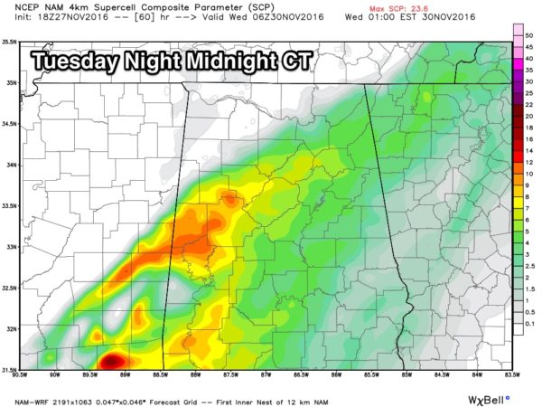
Dewpoints will be in the 60s, and with a diffluent upper flow/strong wind fields, it looks like thunderstorms Tuesday night could produce strong, perhaps damaging straight line winds in spots, and a tornado can’t be ruled out. But again, we will have a much better idea of the threat from “round two” Tuesday morning after “round one” ends.
REMEMBER: We haven’t had active weather in a long time. Be sure you can hear severe weather watches and warnings if they are needed. And, since this active weather will come during the late night/pre-dawn hours, be sure you have a NOAA Weather Radio properly programmed with a battery backup. A good warning app needs to be on your phone as well, like WeatherRadio by WDT.
And, you might want to review your “action plan” with the family just in case. Your safest place is a small room on the lowest floor, near the center of the house, and away from windows. You don’t have to be underground. And, if you live in a mobile home you have to get out, and into a safe place in a site built structure.
If by chance we go go into “wall to wall” severe weather coverage, you can watch us on the ABC 33/40 mobile apps…
ABC 33/40 iOS App
ABC 33/40 Android App
RAIN: On the positive side, these two rounds of storms will bring beneficial rain to Alabama. We still project 2-4 inches of rain for the northern half of the state…
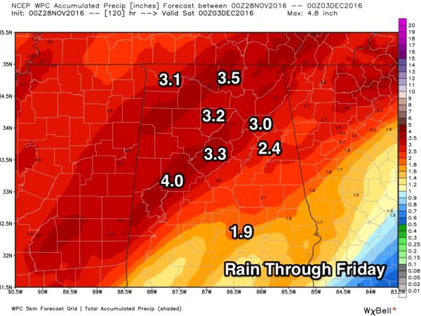
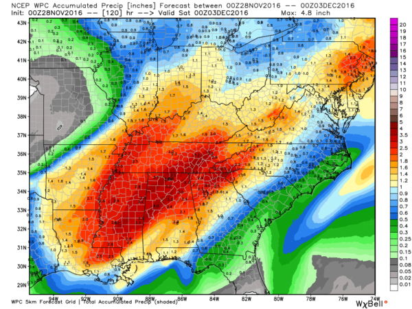
Understand, this won’t end the drought, but it will sure help. Most places need 8-12 inches of rain to get back to where we need to be.
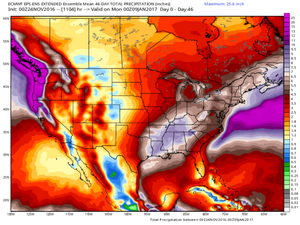
LONG RANGE: The pattern changed back in mid-November (the “pattern flip”) which removed the mean upper ridge across the Southeast U.S., which has been blocking rain producers. The first two waves came through with no moisture, and only light and spotty rain, but you can see what happens this week with deep moisture in place. The overall idea is that relatively wet/stormy weather will continue into December; the European global model ensemble output to 45 days looks very encouraging for a parched Alabama…
Keep an eye on the blog for updates!
Category: Alabama's Weather
About the Author (Author Profile)
James Spann is one of the most recognized and trusted television meteorologists in the industry. He holds the AMS CCM designation and television seals from the AMS and NWA. He is a past winner of the Broadcast Meteorologist of the Year from both professional organizations.Subscribe
If you enjoyed this article, subscribe to receive more just like it.


