Strong/Severe Storms Tomorrow Night
WILD WEEKEND WEATHER CHANGES: Hang on to your hat for some very fast paced weather changes over the next 72 hours… you might consider taking some time to watch the Weather Xtreme video for all of the maps and graphics that go with this post.
TOMORROW: We zoom into the low 70s tomorrow afternoon, almost 50 degrees warmer than the lows we experienced this morning. The day will be cloudy, a gusty south wind will develop, and showers are likely. The most widespread rain tomorrow will be along and north of I-20 (along and north of a line from Tuscaloosa to Birmingham to Anniston).
SEVERE STORMS POSSIBLE TOMORROW NIGHT: SPC maintains the standard “slight risk” of severe storms for far Northwest Alabama tomorrow night, from Muscle Shoals down to Reform, with a “marginal risk” as far east as Gadsden, Calera, and Thomasville…
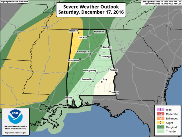
Dewpoints will surge into the mid 60s tomorrow night, and surface based CAPE values will rise to 500 j/kg in spots over West Alabama, meaning the air is unstable ahead of an approaching Arctic surface front.
The main window for severe storms will come from 10:00 p.m. tomorrow through 4:00 a.m. Sunday, and the highest risk will be west of I-65.
The core threat will come from strong straight line winds, but helicity values suggest an isolated tornado will be possible, especially in the “slight risk” area.
Just be sure you are in a position to hear severe weather warnings tomorrow night and very early Sunday morning if they are needed. On the positive side, rain amounts of 1-2 inches are likely.
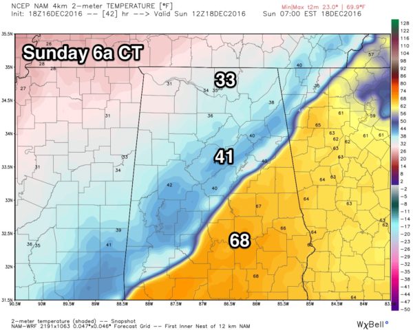
BACK INTO THE DEEP FREEZE SUNDAY: The Arctic front should be south of Birmingham by 6:00 a.m. Sunday… temperatures over North Alabama will hold in the 30s all day with a brisk north wind. To the south, temperatures will fall from the mid to upper 60s into the 40s and 30s later in the day.
FREEZING RAIN/SLEET FOR FAR NORTH ALABAMA? As the rain ends and cold air rushes into the state, there is a chance could see a little freezing rain or sleet on the back side of the precipitation Sunday. Little if any impact is expected, however… if there is any ice accumulation, the greatest chance will be north of the Tennessee River over far North Alabama and up into Tennessee. If you are traveling north Sunday just pay attention to weather conditions.
NEXT WEEK AND BEYOND: Global models are now suggesting the week will be cool and dry with seasonal temperatures. For the Christmas weekend, looks like rain will be possible just west of Alabama. And, sorry snow fans, no evidence of any chance of a “White Christmas” here in Alabama this year.
WEATHER BRAINS: Don’t forget you can listen to our weekly 90 minute netcast anytime on the web, or on iTunes. This is the show all about weather featuring many familiar voices, including our meteorologists here at ABC 33/40.
CONNECT: You can find me on all of the major social networks…
Facebook
Twitter
Google Plus
Instagram
I enjoyed seeing the students at Fairview High School in Cullman County today… be looking for them on the Pepsi KIDCAM today at 5:00 on ABC 33/40 News! My next Weather Xtreme video will be posted bright and early Monday morning by 7:00… Brian Peters will have the video updates tomorrow and Sunday. Enjoy the weekend!
Category: Alabama's Weather
About the Author (Author Profile)
James Spann is one of the most recognized and trusted television meteorologists in the industry. He holds the AMS CCM designation and television seals from the AMS and NWA. He is a past winner of the Broadcast Meteorologist of the Year from both professional organizations.Subscribe
If you enjoyed this article, subscribe to receive more just like it.


