SPC Comments on Increasing Icing Threat
Here is additional information from the Storm Prediction Center regarding the threat of sleet and freezing rain across Central Alabama.
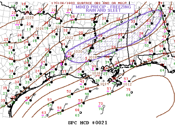
Mesoscale Discussion 0021
NWS Storm Prediction Center Norman OK
0209 PM CST Fri Jan 06 2017
Areas affected…Mixed precipitation – freezing rain and sleet
Concerning…Winter mixed precipitation
Valid 062009Z – 070215Z
SUMMARY…Freezing rain and sleet will increase along a corridor
from central LA, across central MS, into central AL this
afternoon/evening. Significant icing, with rates approaching .10
inch/hr in heavier convection, is expected.
DISCUSSION…Latest vis satellite imagery exhibits deepening
convection across the lower Sabine river valley extending into
southern portions of MS. Lightning is increasing within the taller
updrafts, partly in response to increasing ascent ahead of
approaching short-wave trough. An elongated corridor of
precipitation, with embedded thunderstorms, is expected to expand in
areal coverage/intensity over the next several hours from the lower
Mississippi Valley to the central Gulf states.
With boundary-layer temperatures expected to cool a few degrees
along this corridor it appears the risk for significant icing will
increase as the afternoon progresses into the evening hours. As the
cold air deepens, sleet will become common along the nrn edge of
this expanding precip shield. With time, mixed precipitation will
spread into northern GA later this evening.
..Darrow.. 01/06/2017
Category: Winter Weather
About the Author (Author Profile)
Bill Murray is the President of The Weather Factory. He is the site's official weather historian and a weekend forecaster. He also anchors the site's severe weather coverage. Bill Murray is the proud holder of National Weather Association Digital Seal #0001 @wxhistorianSubscribe
If you enjoyed this article, subscribe to receive more just like it.


