Severe Weather Threat Still for Central Alabama this Evening
A low end severe weather threat continues to unfold for Central Alabama for tonight. It is certainly something you will want to keep in mind as you plan your evening activities.
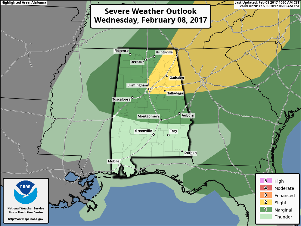
The SPC has upgraded the severe weather outlook category from marginal to slight for areas from Birmingham northeast to the Chattanooga area. Places in the upgraded risk include:
Birmingham
Oneonta
Ashville
Talladega
Guntersville/Albertville
Gadsden
Scottsboro
Fort Payne
Centre
Annison/Heflin
Talladega
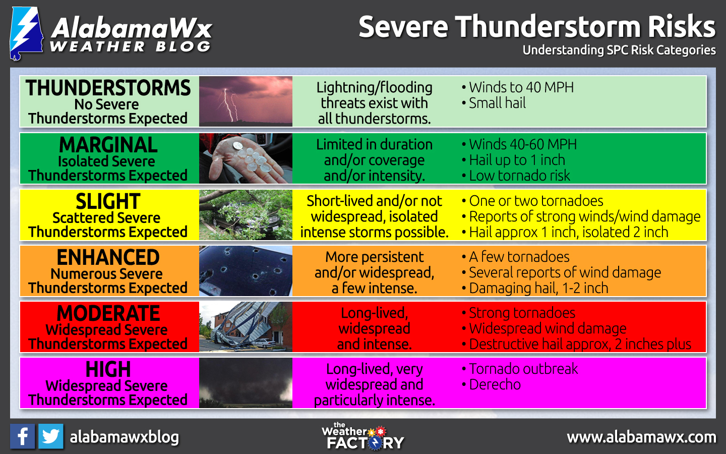
The slight risk means scattered severe storms are possible.
The rest of the area is in a marginal risk, meaning isolated severe storms are possible.
Here is the NWS Birmingham graphic about the threat:
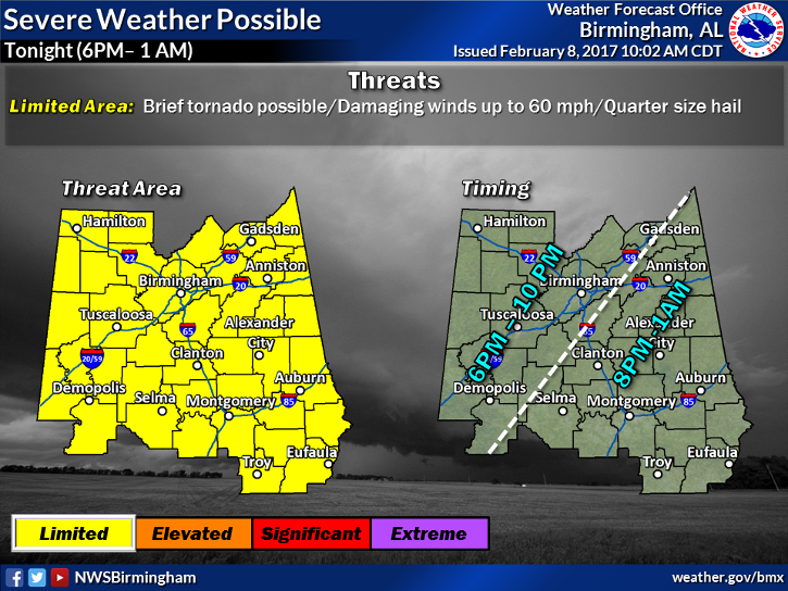
It is a low confidence forecast for sure. But a low end threat isn’t so low end if it drops a tree on your house or flips your trailer home.
Here are the meteorological players for the event:
…An approaching cold front that is south of Nashville early this afternoon
…A deck of low clouds over Central Alabama that is eroding from the southwest. The clearing line has reached Pickesn, Greene and Perry Counties. Skies will be clearing in Tuscaloosa shortly. In the sunshine, temperature are already in the 70s. The temperature at Meridian jumped from 64 to 73F.
…Dewpoints are in the lower 60s across the area.
…With the heating of the day, instability values should rise into the 1,000-2,000 joules range across eastern Mississippi and western Alabama. These are some very healthy numbers for big storms, but…
…There is a stout capping inversion on the lower atmosphere that will keep those storms from forming through the afternoon. Only isolated showers will be able to form until the front gets closer.
…A strong upper level jet max of over 110 knots will overspread the Tennessee Valley by mid to late afternoon. This will provide some additional lift for storms that do form.
…Strong winds at about 18,000 feet as well will provide high speed shear, so storms will be organized.
…There is veering of winds with height, from southwesterly in the lower atmosphere to northwesterly further aloft, and veering is veering, so there will be some helicity. This means an isolated tornado isn’t out of the question if we get strong updrafts.
So the question is: will any storms form?
The best mesoscale models depict a thin line of storms forming around Marion County around 6p.m. That line will build a bit as it progresses southeast.
…Tuscaloosa/Birmingham 7-8 p.m.
…Anniston/Clanton 830-930 p.m.
…Montgomery 9-10 p.m.
Of course, your timing may vary.
The main threats will be large hail with the steep mid level lapse rates. Damaging winds will certainly be possible in the stronger storms with the strong wind profiles. And there is that outside chance of a tornado.
Take time to review your severe weather safety plan.
We will be monitoring the situation minute by minute and will have frequently updates as well as any warnings that get issued right here on AlabamaWX.com.
Category: Alabama's Weather
About the Author (Author Profile)
Bill Murray is the President of The Weather Factory. He is the site's official weather historian and a weekend forecaster. He also anchors the site's severe weather coverage. Bill Murray is the proud holder of National Weather Association Digital Seal #0001 @wxhistorianSubscribe
If you enjoyed this article, subscribe to receive more just like it.


