A Few Weekend Storms; Cooler Sunday
RADAR CHECK: As expected, most of Alabama is rain-free this afternoon… we have just a few isolated showers over the far eastern counties of the state. With a partly sunny temperatures have warmed into the mid 80s again.
The weather won’t change much tomorrow; warm and generally dry, although a few scattered showers and storms could fire late in the day. The best chance of storms tomorrow evening will be over far North Alabama, near the Tennessee border, where SPC has defined a “marginal risk” of severe storms. The high tomorrow will be right back in the mid 80s.
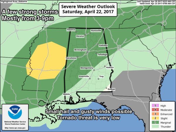
THE WEEKEND: A surface low will move along the front north of Alabama; it should be near Nashville by Saturday evening. Showers and storms should form along the trailing cold front, moving through Alabama during the afternoon and evening hours. SPC has a “marginal” severe weather risk defined for about the northern two-thirds of the state…
The new model set this morning shows a setup less than impressive for severe storms in Alabama; wind fields are relatively weak, and instability and shear values are marginal. The good news is that the overall severe weather threat looks pretty low, but the bad news is that the expected rain amounts will need to come down. Keep in mind today is the 16th consecutive day without measurable rain for Birmingham.
TIMING: The main window for stronger storms will come from 3:00 p.m. until 9:00 p.m. Saturday.
THREATS: Heavier storms could produce small hail and gusty winds. The tornado risk is very low.
RAIN: Based on new model data, it now looks like most places will see 1/2 inch or less.
But, understand this is late April, and you have to watch any setup like this closely. Model guidance is just that… and sometimes storms don’t behave according to plan.
Sunday will be breezy and much cooler; some risk of a little light rain during the morning. We won’t get out of the 60s, and some far North Alabama communities could hold in the 50s all day. Some slow afternoon clearing is possible.
NEXT WEEK: Monday morning will be cool for late April with temperatures dropping into the upper 40s; the day Monday will be bright and sunny with a high in the 70s. The rest of the week looks dry with a warming trend; afternoon temperatures return to the 80s Wednesday through Friday. The GFS is advertising a strong system due in here late in the following weekend (around Sunday April 30) that could bring active thunderstorms back to the state. See the Weather Xtreme video for maps, graphics, and more details.
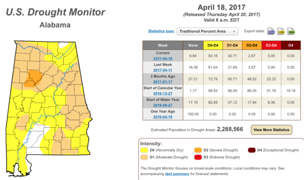
DROUGHT MONITOR: The new drought monitor released this morning shows drought conditions starting to increase again across our state due to the lack of widespread rain over the past two weeks…
HONDAY INDY GRAND PRIX: It begins tomorrow at the beautiful Barber Motorsports Park! Make plans for the event that has been voted “Best Annual Event” & “Best Sporting Event” in Birmingham. Kids 15 & under are admitted free with a ticketed adult, and three-day general admission tickets are $69. Single day tickets are $15. Pack a picnic/cooler and bring the family out for a weekend full of activities and racing! Get tickets and more information here. Looks like the best chance of showers and storms will come from about 4 p.m. through 9 p.m. Maybe a touch of light rain Sunday morning. Get the detailed race cast here.
ALABAMA A DAY: The annual spring game kicks off at 2:00 Saturday afternoon at Bryant-Denny Stadium in Tuscaloosa. A good chance conditions will be dry at the beginning of the game, but there is a chance of showers, and possibly a thunderstorm, during the second half. The temperature will be near 80 degrees at kickoff.. I will be doing “Drive Home Weather” on the big screens with former Tide star Andre Smith (now with the Cincinnati Bengals). Come see us in the fan zone at the KS Services booth from 11 a.m. until 12 noon.
MUSIC AND MIRCALES SUPERFEST: The Music and Miracles Superfest will be held at Jordan-Hare Stadium Saturday starting at 3:00… best chance of rain there will come after 8:00 p.m. While a thunderstorm is possible Saturday night, the severe weather risk in Lee County is pretty low.
Click here to see the Beach Forecast Center page. Save Up To 25% on Spring Break Beach Vacations on the Alabama Gulf Coast with Brett/Robinson! The Beach Forecast is partially underwritten by the support of Brett/Robinson Vacation Rentals in Gulf Shores and Orange Beach. Click here to see Brett/Robinson’s best beach offers now!
STORM SPOTTER TRAINING IN JASPER THIS EVENING: The last spotter training event of the year will be held in Jasper this evening; we will be at the Jasper Civic Center, and the session begins at 6:30. It is free, and there is no need to register. Just come with a curious mind!
WEATHER BRAINS: Don’t forget you can listen to our weekly 90 minute netcast anytime on the web, or on iTunes. This is the show all about weather featuring many familiar voices, including our meteorologists here at ABC 33/40.
CONNECT: You can find me on all of the major social networks…
Facebook
Twitter
Google Plus
Instagram
Pinterest
Snapchat: spannwx
Look for the next Weather Xtreme video here by 7:00 a.m. tomorrow…
Category: Alabama's Weather, ALL POSTS, Weather Xtreme Videos
About the Author (Author Profile)
James Spann is one of the most recognized and trusted television meteorologists in the industry. He holds the AMS CCM designation and television seals from the AMS and NWA. He is a past winner of the Broadcast Meteorologist of the Year from both professional organizations.Subscribe
If you enjoyed this article, subscribe to receive more just like it.


