Latest Weather Xtreme Video: Cloudy and Much Cooler Today
Saturday’s severe weather event didn’t turn out badly at all for Alabama. One tornado affected Franklin County and there were a couple of reports of large hail as well as 7 reports of high winds. Quarter sized hail fell near Russellville and one inch hail fell near Hazel Green. A chicken house was damaged in Cullman County and some cards were overturned near West Point. Multiple trees were down on houses in the same area. More trees were down near Skyline in Jackson County. Teams from the NWS in Huntsville will be out today surveying the damage. But all in all, it wasn’t a bad day.
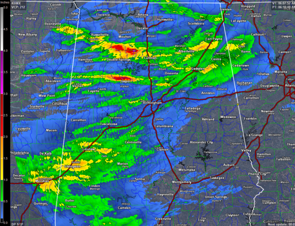
RAINFALL AMOUNTS: The best rainfall amounts fell in swaths along the paths of the strongest storms. The heaviest rain fell across Lawrence, Winston and Walker Counties, where between 2 and 3 inches of rain fell. Less than 20% of the area picked up between 0.50 inches and one inch. Much of the area south and east of Birmingham picked up less than 0.05 inches. The rain across Walker and Winston Counties helped those drought stricken areas, but the relief was isolated unfortunately.
TODAY: Today will be quite a different day than yesterday. A brisk westerly wind will shift around to northwest during the morning. Instead of highs in the 80s, the mercury will struggle to make the middle 60s. Some of the cooler spots up in the Tennessee Valley may not make it out of the 50s!
CUT OFF LOW, WEATHERMAN’S WOE: The mid-level trough may try to cut off into a closed low over Tennessee today. A wave of stouter showers is moving through this morning, followed by a lull and then another wave of sprinkles or drizzle later this afternoon. Skies will be mostly cloudy, although there may be peeks of sunshine at times.
INDYCAST: The big race is today! Fans will dodge a few showers, but these machines race even if it rains! So carry the rain gear just in case and get ready for an exciting day at the track. Temperatures will be cooler, topping out in the middle 60s about the time the green flag drops.
LINGERING SHOWERS: A few showers may still be hanging around until after midnight tonight, but they should be gone by Monday morning. Lows tonight will be in the upper 40s to lower 50s.
MONDAY PERFECTION: Monday will be a perfect day, with tons of sunshine after a cool start. Highs will top out in the middle and upper 70s.
THE HEAT RETURNS: We will be back in the above normal department by Tuesday as a flat ridge of high pressure begins to build in over Alabama and the Deep South.
NEXT RAIN CHANCES: Using the European as the inspiration for this forecast, we will call for a chance of showers late Wednesday night or Thursday morning. Rainfall amounts will be light. The weak front will come back north as a warm front Friday, producing more showers and storms. The main event should come Sunday or Sunday night as a stronger surface low moves from Missouri to Illinois.
GULF COAST WEATHER: Another great week at the beach, as soon as we get past today’s showers. Expect a good supply of sunshine with highs in the upper 70s and lower 80s. Lows will trend back to the 60s. Water temperatures are already back in the upper 70s.
Click here to see the Beach Forecast Center page. Save Up To 25% on Spring Break Beach Vacations on the Alabama Gulf Coast with Brett/Robinson! The Beach Forecast is partially underwritten by the support of Brett/Robinson Vacation Rentals in Gulf Shores and Orange Beach. Click here to see Brett/Robinson’s best beach offers now!.
WEATHERBRAINS: We will be talking to one of the world’s smartest Weatherbrains around as Dr. Shawn Miller joins the show. He is in charge of the AMS Washington Forum. He is also a leading expert on satellites. Check out the show at www.WeatherBrains.com. You can also subscribe on iTunes. You can watch the show live at live.bigbrainsmedia.com You will be able to see the show on the James Spann 24×7 weather channel on cable or directly over the air on the dot 2 feed.
Category: Alabama's Weather, ALL POSTS, Weather Xtreme Videos
About the Author (Author Profile)
Bill Murray is the President of The Weather Factory. He is the site's official weather historian and a weekend forecaster. He also anchors the site's severe weather coverage. Bill Murray is the proud holder of National Weather Association Digital Seal #0001 @wxhistorianSubscribe
If you enjoyed this article, subscribe to receive more just like it.


