Quiet At Midday, But Strong/Severe Storms Possible After Midnight
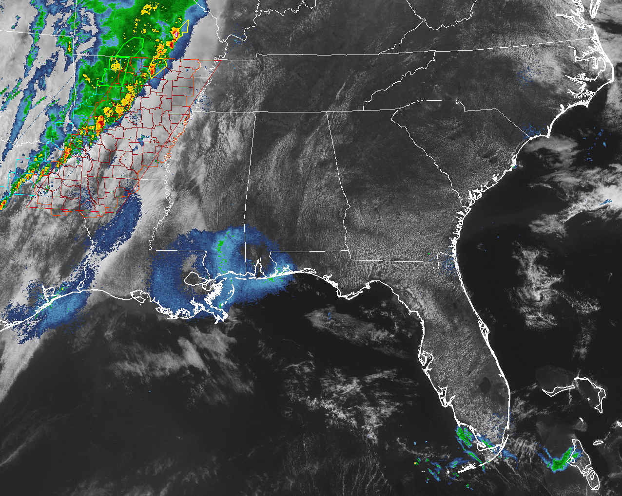
As you can see by the image above, conditions are rather nice across North/Central Alabama. Skies are mostly clear and we have a nice breeze to help keep these warm temperatures feeling comfortable. The main action that we will have later tonight and into the early morning hours on Thursday is currently back off to our west. A line of strong to severe storms is currently located over the north/central parts of Arkansas and stretching back to the southwest through eastern Texas.
A Tornado Watch is currently in effect for much of Arkansas, Northwest Louisiana, and Northeast Texas until 5PM CDT, along with a Severe Thunderstorm Watch just along and west of that until 1:00PM CDT. A few tornadoes are likely with a couple of intense tornadoes, along with damaging large hail up to 2″ in diameter, and damaging wind gusts up to 70 MPH are likely within the tornado watch area.
For the remainder of the afternoon and early evening hours, skies will be mostly clear for a few more hours before clouds start to build in from the west. Winds will be on the increase as the afternoon progresses, reaching 10-15 MPH out of the south with gusts of 25 MPH possible. Highs will top out in the mid 80s, with a few locations reaching the upper 80s.
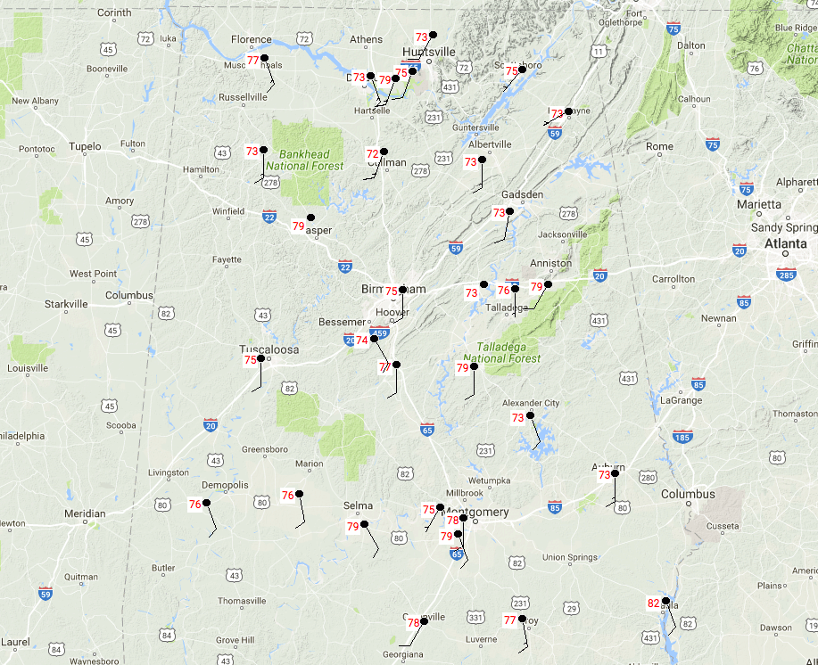
Temperatures at the midday hour are in the 70s for the most part across North/Central Alabama. The warm spot at the moment is Eufaula at 82 degrees, with the cool spot of Cullman at 72 degrees.
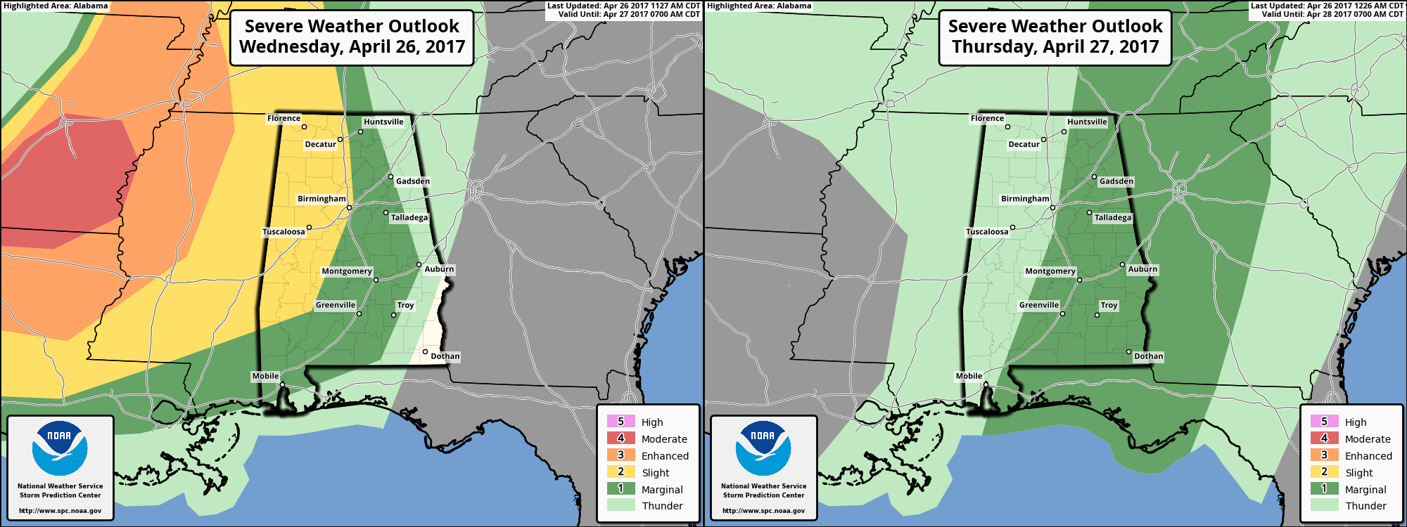
The line of storms is expected to move into the area starting right around midnight, and progress through the state throughout the overnight and early morning hours on Thursday. The SPC has much of the western half of the state in a slight risk for severe storms from tonight through 7AM Thursday morning. The main threats will be from damaging straight line winds up to 60 MPH, along with hail. The overall tornado risk still looks rather low at this point, but a brief spin-up or two are possible. As the line moves across the state, it will weaken, and locations east of I-65 will have a marginal (at best) risk for severe storms, with the main threat being from damaging winds.
During the late morning hours on Thursday, the line of storms will be reaching the AL/GA state line, and most of the storms will be out of the state by noon. Clouds will be on the decrease and skies will be mostly clear by the late afternoon hours. Highs will be in the mid 70s to the mid 80s across the area.
Go ahead and have your place of safety and emergency supplies ready to go just in case you are placed in a warning later tonight. Have your smartphones charged. Check the batteries in your NOAA Weather Radio and in your flashlights. Stay weather aware this evening, and keep checking back with the Alabama Wx Weather Blog for updates.
If you would like to see what the weather holds for Ft. Morgan over to Panama City Beach, click here to see the Beach Forecast Center page. Save Up To 25% on Spring Break Beach Vacations on the Alabama Gulf Coast with Brett/Robinson! The Beach Forecast is partially underwritten by the support of Brett/Robinson Vacation Rentals in Gulf Shores and Orange Beach. Click here to see Brett/Robinson’s best beach offers now!
ON THIS DAY IN WEATHER HISTORY – April 26, 1991
Severe thunderstorms in the central U.S. spawned fifty-five tornadoes from northeastern Texas to Iowa and eastern Nebraska killing twenty-one persons. Early evening thunderstorms over south central Kansas spawned a violent (F-5) tornado whiched traveled 45 miles from southwest of Wichita to north of El Dorado. It killed seventeen persons, including thirteen at the Golden Spur Mobile Home Park in Andover. The tornado also caused 62 million dollars damage to McConnell Air Force Base as it crossed the south side of Wichita.
Category: Alabama's Weather, ALL POSTS
About the Author (Author Profile)
Scott Martin is an operational meteorologist, professional graphic artist, musician, husband, and father. Not only is Scott a member of the National Weather Association, but he is also the Central Alabama Chapter of the NWA president. Scott is also the co-founder of Racecast Weather, which provides forecasts for many racing series across the USA. He also supplies forecasts for the BassMaster Elite Series events including the BassMaster Classic.Subscribe
If you enjoyed this article, subscribe to receive more just like it.


