Severe Weather Threat Overnight
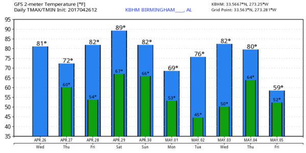
THIS AFTERNOON: We have warm, dry afternoon across the great state of Alabama with temperatures generally in the 79-83 degree range. But, to the west, a dynamic storm system is producing thunderstorms over Arkansas, Louisiana, and Northeast Texas, and those will move into our state late tonight.
New high resolution model data is now suggesting potential for the line of storm to become more “cellular” after midnight in Alabama, and with high storm relative helicity values we will need to hit the chance of a tornado or two a little harder. The limiting factor will be somewhat marginal instability values, but they are sufficient for severe storms.
SPC has the standard “slight risk” of severe weather defined for most of the state along and west of I-65, with a “marginal risk” to the east. Keep in mind this “Day 1” outlook runs through 7 a.m. tomorrow…
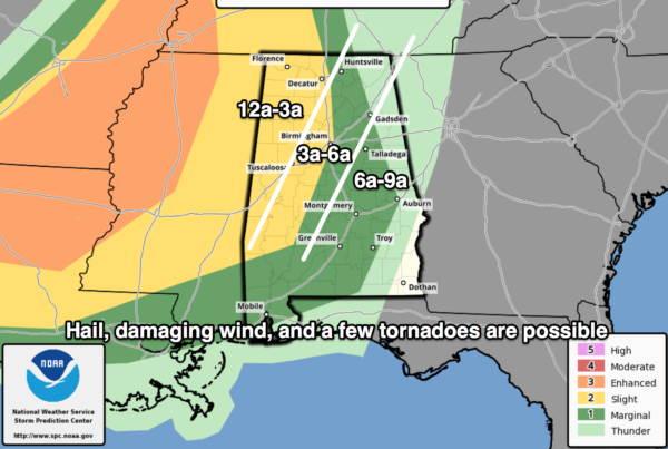
TIMING: The storms should enter West Alabama around midnight tonight, then passing eastward during the pre-dawn hours, and finally moving out of the state by 9:00 a.m. tomorrow. The should be in the Birmingham metro in the 3-6 a.m. time frame.
THREATS: Heavier storms overnight will be capable of producing hail and damaging straight line winds. A few tornados are possible as well, especially south of I-20.
RAIN: Rain amounts of around 1/2 inch are likely, with isolated heavier totals. No flooding issues.
CALL TO ACTION: Be sure you have a way of getting warnings, especially with an overnight event like this. A NOAA Weather Radio is the baseline, and a good smart phone app is the other tier. Identify the safe place in your home, and be sure everyone knows where it is. And, in that safe place have helmets for everyone, along with hard sole shoes and preferably a portable airhorn in case you need help.
Be sure you have the ABC 33/40 app on your phone so you can watch our live severe weather coverage, if needed:
The sky becomes partly to mostly sunny tomorrow afternoon as drier air works into the state; the high will be in the 77-80 degree range.
FRIDAY/SATURDAY: These two days will be very warm and mostly dry; we will mention “isolated, mostly afternoon and evening thunderstorms” both days due to high instability values. Highs will be in the upper 80s; a few spots might even touch 90 degrees.
MORE STORMS SUNDAY: Another robust spring weather system will sweep into the state Sunday with another risk of strong to severe storms. Main window for severe weather, for now, seems to be in the 12:00 noon to 12:00 midnight time frame. Way too early to be specific about the magnitude of the threat, let’s get through the storms late tonight and then we can focus on Sunday.
NEXT WEEK: Monday and Tuesday will be dry with pleasant afternoons and cool nights; next chance of showers and storms will come around Thursday, followed by more cool air. See the Weather Xtreme video for maps, graphics, and more details.
Click here to see the Beach Forecast Center page. Save Up To 25% on Spring Break Beach Vacations on the Alabama Gulf Coast with Brett/Robinson! The Beach Forecast is partially underwritten by the support of Brett/Robinson Vacation Rentals in Gulf Shores and Orange Beach. Click here to see Brett/Robinson’s best beach offers now!
WEATHER BRAINS: Don’t forget you can listen to our weekly 90 minute netcast anytime on the web, or on iTunes. This is the show all about weather featuring many familiar voices, including our meteorologists here at ABC 33/40.
CONNECT: You can find me on all of the major social networks…
Facebook
Twitter
Google Plus
Instagram
Pinterest
Snapchat: spannwx
I had a great time today visiting with the students at Jim Pearson Elemntary in Alexander City… be looking for them on the Pepsi KIDCAM today at 5:00 on ABC 33/40 News! The next Weather Xtreme video will be posted here by 7:00 a.m. tomorrow…
Category: Alabama's Weather, ALL POSTS, Weather Xtreme Videos
About the Author (Author Profile)
James Spann is one of the most recognized and trusted television meteorologists in the industry. He holds the AMS CCM designation and television seals from the AMS and NWA. He is a past winner of the Broadcast Meteorologist of the Year from both professional organizations.Subscribe
If you enjoyed this article, subscribe to receive more just like it.


