Strong/Severe Storms Return Late In The Weekend
SUNNY AFTERNOON: Storms have exited Alabama this afternoon; most communities are enjoying a sunny sky with temperatures in the upper 70s. Tonight will be mostly fair and calm.
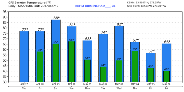
TOMORROW/SATURDAY: We warm into the mid 80s tomorrow and upper 80s Saturday with a mix of sun and clouds both days. We will continue to mention just a few isolated afternoon storms, but many communities will be dry.
To the west, active storms will develop both days, some possibly severe.
SUNDAY: A robust weather system west of the state will bring storms back into Alabama by mid to afternoon, and into Sunday night. Ahead of the storm, strong south winds will gust to 30 mph at times, with temperatures warming into the mid 80s. Seems like the main window for storms will come from 4:00 p.m. Sunday through 4:00 a.m. Monday.
While models are not forecasting a tremendous amount of instability, they are showing strong low level shear and good dynamic lift, and it looks like a situation once again where all modes of severe weather will be possible. Large hail, strong straight line winds, and a few tornadoes. We will be much more specific as the event gets closer.
On the positive side, beneficial rain is likely, with most places seeing at least one to two inches.
NEXT WEEK: Monday will be breezy and much cooler with a clearing sky; Monday’s high will be close to 70 degrees. And, by daybreak Tuesday we have a good chance of dropping into the cool 40s.
The next rain/storm event will come on Thursday (May 4), followed by more cool air Friday (May 5). Long range guidance from the GFS suggests we could be close to 40 degrees by daybreak Saturday May 6. See the Weather Xtreme video for maps, graphics, and more details.
PIKE COUNTY TORNADO: According to Pike County EMA, a tornado touched down late this morning northeast of Troy… approximately 1/2 mile damage path, several homes damaged due to down trees. Some power lines are damaged as well. NWS will send a survey team in to determine rating.
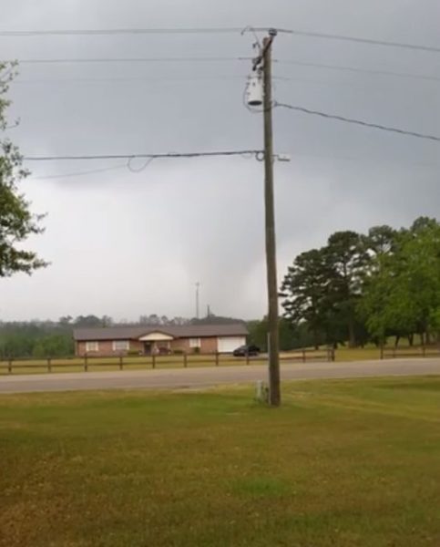
Picture from Crenshaw County EMA.
Click here to see the Beach Forecast Center page. Save Up To 25% on Spring Break Beach Vacations on the Alabama Gulf Coast with Brett/Robinson! The Beach Forecast is partially underwritten by the support of Brett/Robinson Vacation Rentals in Gulf Shores and Orange Beach. Click here to see Brett/Robinson’s best beach offers now!
WEATHER BRAINS: Don’t forget you can listen to our weekly 90 minute netcast anytime on the web, or on iTunes. This is the show all about weather featuring many familiar voices, including our meteorologists here at ABC 33/40.
CONNECT: You can find me on all of the major social networks…
Facebook
Twitter
Google Plus
Instagram
Pinterest
Snapchat: spannwx
I enjoyed seeing the students at Whitesboro Elementary this morning (up in Etowah County)… be looking for them on the Pepsi KIDCAM today at 5:00 on ABC 33/40 News! The next Weather Xtreme video will be posted here by 7:00 a.m. tomorrow…
Category: Alabama's Weather, ALL POSTS, Weather Xtreme Videos
About the Author (Author Profile)
James Spann is one of the most recognized and trusted television meteorologists in the industry. He holds the AMS CCM designation and television seals from the AMS and NWA. He is a past winner of the Broadcast Meteorologist of the Year from both professional organizations.Subscribe
If you enjoyed this article, subscribe to receive more just like it.


