Clearing, Windy, Cooler Today
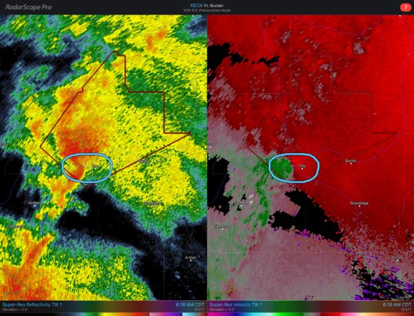
RADAR CHECK: We still have lingering showers and a few thunderstorms over the eastern half of Alabama early this morning; even a few severe storms over Southeast Alabama. A tornado warning was issued for Pike County around 6:15…
Rain will exit the state by mid-morning, and the sky becomes partly to mostly sunny by afternoon as cooler, drier air flows into the state. There is a tight surface pressure gradient in place, meaning strong west winds in the 15-30 mph, with gusts to 40 mph in spots. The NWS had a wind advisory in effect for much of Alabama today. Hang on to your hat.
Tonight will be clear and cool with diminishing wind; cooler spots will visit the 40s early tomorrow morning. Then, during the day tomorrow, expect sunshine in full supply with an afternoon high in the 77 to 80 degree range.
MORE RAIN LATER THIS WEEK: The day Wednesday looks dry and warm with a mix of sun and clouds with a high in the low 80s. Then, clouds return quickly Wednesday evening, and we will mention periods of rain with a few thunderstorms Wednesday night and Thursday. A deepening surface low will pass north of Alabama with decent upper support, which is usually a favorable setup for severe storms in early May. But, there is very little instability, and accordingly SPC for now does not have a severe weather risk defined for Thursday.
Rain amounts of 1 inch are likely with this event; some spots could see more. The rain should end Thursday night as the system lifts northeast.
FRIDAY AND THE WEEKEND: Friday looks like a windy, cool day with slow clearing; a very good chance we won’t get out of the 60s. Saturday morning looks downright chilly as the weekend begins; the GFS is hinting at low 40s for Birmingham, meaning colder spots across North and Central Alabama could actually drop into the upper 30s. The rest of the weekend looks delightful with sunny days; the high Saturday will be close to 70, followed by 80 degree warmth Sunday afternoon.
NEXT WEEK: A blocked upper air pattern over the nation should bring fairly tranquil weather to Alabama for much of the week with temperatures at, or maybe a bit below seasonal averages. See the Weather Xtreme video for maps, graphics, and more details.
Click here to see the Beach Forecast Center page. Save Up To 25% on Spring Break Beach Vacations on the Alabama Gulf Coast with Brett/Robinson! The Beach Forecast is partially underwritten by the support of Brett/Robinson Vacation Rentals in Gulf Shores and Orange Beach. Click here to see Brett/Robinson’s best beach offers now!
WEATHER BRAINS: Don’t forget you can listen to our weekly 90 minute netcast anytime on the web, or on iTunes. This is the show all about weather featuring many familiar voices, including our meteorologists here at ABC 33/40. We will produce this week’s show tonight at 8:30 CT… you can watch it live here.
CONNECT: You can find me on all of the major social networks…
Facebook
Twitter
Google Plus
Instagram
Pinterest
Snapchat: spannwx
I have a weather program today at Coosa Valley Elementary School in Pell City… look for the next Weather Xtreme video here by 4:00 this afternoon. Enjoy the day!
Category: Alabama's Weather, ALL POSTS, Weather Xtreme Videos
About the Author (Author Profile)
James Spann is one of the most recognized and trusted television meteorologists in the industry. He holds the AMS CCM designation and television seals from the AMS and NWA. He is a past winner of the Broadcast Meteorologist of the Year from both professional organizations.Subscribe
If you enjoyed this article, subscribe to receive more just like it.


