Latest Weather Xtreme Video: Nice Warm Up Today; Rain Returns Thursday
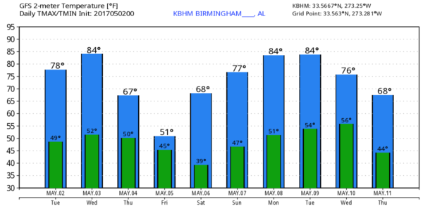
COOL MAY MORNING: Many communities have dropped into the 40s early this morning; one of the colder spots just before sunrise is Fort Payne with 43 degrees.
Despite the morning chill, temperatures warm quickly today, and we expect a high close to 80 this afternoon with sunshine in full supply. The weather stays dry during the day tomorrow; with a partly sunny sky we rise into the mid 80s.
RAIN RETURNS: A storm system will develop west of the state tomorrow, and promises to push rain in here late tomorrow night and during the day Thursday. A deepening surface low will pass just north of Alabama, and there is potential for a few strong storms, especially over the southern half of the state.
SPC has parts of Central and South Alabama in a “marginal risk” of severe weather for after midnight tomorrow night in their “Day Two” outlook that runs through 7:00 a.m. Thursday.
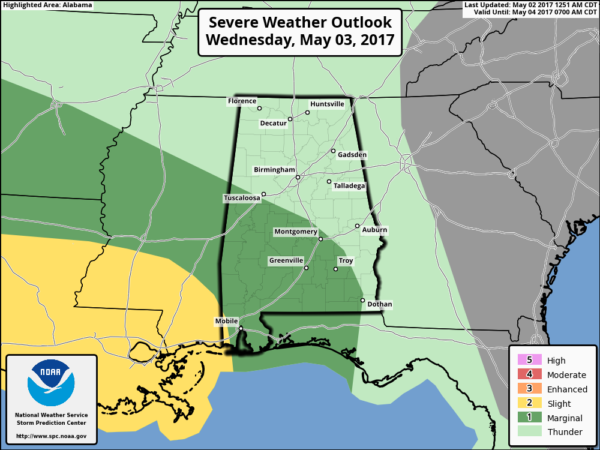
The lack of surface based instability is the primary limiting factor with this event.
TIMING: The main window for rain and storms will come from about midnight tomorrow night through 6:00 p.m. Thursday. Understand it certainly won’t rain that entire period, but we will have periods of rain and a few thunderstorms.
THREATS: Storms over the southern half of the state could produce small hail and strong gusty winds. An isolated tornado can’t be ruled out over South Alabama.
RAIN: Rain amounts of around 1 inch are likely for the northern half of Alabama, with potential for more over the southern counties of the state. Flooding is not expected to be an issue.
While the overall severe weather threat with this feature looks fairly low, understand we have to watch any weather system that blows through here in early May, and when it comes to thunderstorms, “expect the unexpected”.
FRIDAY: This looks like a breezy, raw, and chilly day for early May. Also, we will need to mention the chance of some scattered light rain with moisture wrapping around the back side of the departing storm system under a mostly cloudy sky. Temperatures, most likely, won’t get out of the 50s, and a north wind of 10-20 mph will make it feel colder. Not exactly a “Chamber of Commerce” type day.
THE WEEKEND: Saturday morning will be cold for May. Most places will bottom out in the low 40s; colder pockets will see upper 30s. Then, we expect a very nice weekend with sunshine in full supply both days. The high Saturday will be close to 70, followed by upper 70s Sunday.
RACE WEEKEND AT TALLADEGA: Friday will be windy and cool with more clouds than sun; outside chance of a little light rain. The high Friday will be only around 60 degrees. Then, bright sunny weather Saturday and Sunday with a warming trend; the high Saturday will be 70, then 78 on Sunday.
NEXT WEEK: The week looks very quiet with a dry airmass in place; we warm back into the 80s early in the week, but another surge of cool air settles in by Wednesday and Thursday. Little if any chance of rain. See the Weather Xtreme video for maps, graphics, and more details.
Click here to see the Beach Forecast Center page. Save Up To 25% on Spring Break Beach Vacations on the Alabama Gulf Coast with Brett/Robinson! The Beach Forecast is partially underwritten by the support of Brett/Robinson Vacation Rentals in Gulf Shores and Orange Beach. Click here to see Brett/Robinson’s best beach offers now!
WEATHER BRAINS: Don’t forget you can listen to our weekly 90 minute netcast anytime on the web, or on iTunes. This is the show all about weather featuring many familiar voices, including our meteorologists here at ABC 33/40.
CONNECT: You can find me on all of the major social networks…
Facebook
Twitter
Google Plus
Instagram
Pinterest
Snapchat: spannwx
I have a weather program today at Alexandria Elementary School in Calhoun County… look for the next Weather Xtreme video here by 4:00 this afternoon. Enjoy the day!
Category: Alabama's Weather, ALL POSTS, Weather Xtreme Videos
About the Author (Author Profile)
James Spann is one of the most recognized and trusted television meteorologists in the industry. He holds the AMS CCM designation and television seals from the AMS and NWA. He is a past winner of the Broadcast Meteorologist of the Year from both professional organizations.Subscribe
If you enjoyed this article, subscribe to receive more just like it.


