Strong Storms Possible Tomorrow
RADAR CHECK: So far, showers and storms are pretty widely scattered across North and Central Alabama today… they are showing very little movement…
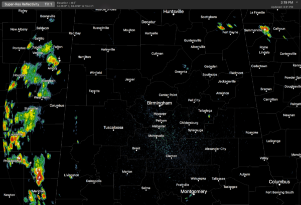
Temperatures are mostly in the upper 80s, and scattered showers will end after sunset.
TOMORROW: SPC has a severe weather risk defined for about the northern two-thirds of Alabama for tomorrow…
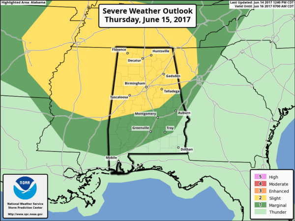
This is for potential for a series of storms moving into Alabama from the northwest. Forecast atmospheric profiles suggest some of the storms could be strong to severe with potential for damaging straight line winds in a few spots. The high resolution HRRR model hints a decaying area of storms could move into Northwest Alabama tomorrow morning, followed by another, stronger batch later in the day into the evening hours. Highest severe weather threat seems to be from about 3:00 until 9:00 p.m.
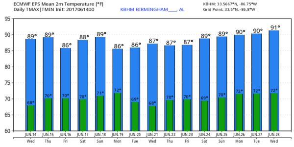
Away from the storms, tomorrow will feature a mix of sun and clouds with a high in the mid to upper 80s.
FRIDAY THROUGH THE WEEKEND: Moist, unstable air will stay in place, and we will forecast some pretty classic early summer weather on these three days. Partly sunny with the risk of “scattered, mostly afternoon and evening showers and thunderstorms” along with highs in the upper 80s. Afternoon storms will be random; no way of knowing in advance exactly when and where they will pop up. Best chance of a storm will come from about 2:00 until 9:00 p.m. daily.
NEXT WEEK: A surface front will creep into North Alabama Monday with showers and storms possible; then showers should become fewer in number Tuesday and Wednesday as drier air tries to slip into the state from the north. See the Weather Xtreme video for maps, graphics, and more details.
TROPICS: One low latitude disturbance in the far eastern Atlantic will move westward in coming days with only low odds of development. And, global models continue to show a tropical low in the far Southwest Gulf of Mexico next week; no sign of it moving northward. Instead, odds are this feature will drift slowly westward toward the coast of Mexico if anything develops in that region. Again, see the Weather Xtreme video for more information on the tropical weather situation.
BEACH FORECAST: Click here to see the AlabamaWx Beach Forecast Center page. The Beach Forecast is partially underwritten by the support of Brett/Robinson Vacation Rentals in Gulf Shores and Orange Beach. Click here to see Brett/Robinson’s Own Your Summer specials now!
WEATHER BRAINS: Don’t forget you can listen to our weekly 90 minute netcast anytime on the web, or on iTunes. This is the show all about weather featuring many familiar voices, including our meteorologists here at ABC 33/40.
CONNECT: You can find me on all of the major social networks…
Facebook
Twitter
Google Plus
Instagram
Pinterest
Snapchat: spannwx
Look for the next Weather Xtreme video here by 7:00 a.m. tomorrow…
Category: Alabama's Weather, ALL POSTS, Weather Xtreme Videos
About the Author (Author Profile)
James Spann is one of the most recognized and trusted television meteorologists in the industry. He holds the AMS CCM designation and television seals from the AMS and NWA. He is a past winner of the Broadcast Meteorologist of the Year from both professional organizations.Subscribe
If you enjoyed this article, subscribe to receive more just like it.


