Isolated Tornadoes Remain Possible Today
A layer of deep tropical moisture remains in place across Alabama this morning with dew points in the mid 70s, and precipitable water values in the 95th percentile. Areas of rain are on radar at daybreak over the northern two-thirds of the state.
TORNADO THREAT: While Cindy has officially dissipated, shear associated with the remnant circulation will provide another favorable environment for rotating showers and storms later today, and SPC has much of North and Central Alabama in a severe weather risk…
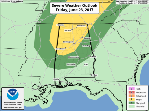
The main window for isolated tornadoes will come from around 12:00 noon through 8:00 p.m., with the main risk along and north of I-20. Like yesterday, these will tend to be short lived, and warning for them is very challenging. Warning lead times will be very short, and in some cases there will be no warning. Pay very close attention to the weather this afternoon and early tonight.
And, due to the tropical nature of the air in place, more heavy downpours are likely today, and a flash flood watch remains in effect for much of Central and West Alabama. One of the highest three day storm totals I have seen is 8.64″ from Lake View in far eastern Tuscaloosa County. The ground is complete saturated, and we could see some trees coming down today in winds less than 40 mph.
THE WEEKEND: The good news is that we don’t expect any severe weather tomorrow, but scattered to numerous showers and storms are likely ahead of a surface cold front. No way of resolving start/stop times of the rain for any given point, but just be ready for a few passing showers and thunderstorms. Then, drier air slips into North Alabama Sunday as the chance of showers will be confined to the southern third of the state, and even there the activity will be pretty scattered in nature. Highs for the weekend will be in the low to mid 80s.
NEXT WEEK: Dry, continental air will cover the state allowing for a nice chance to dry out. Mostly sunny comfortable days, clear cool nights, and low humidity is the forecast Monday through Thursday. A good chance we see lows down in the 50s early Monday and Tuesday morning for a little preview of fall. Moisture will begin to return late in the week, and a few widely scattered showers are possible by Friday. See the Weather Xtreme video for maps, graphics, and more details.
YESTERDAY’S FAIRFIELD TORNADO: A tornado moved through parts of Fairfield and Ensley yesterday; it was rated EF-2 by the NWS Birmingham. There were a few injuries at an ABC Beverage store, but thankfully no fatalities.
BEACH FORECAST: Click here to see the AlabamaWx Beach Forecast Center page. The Beach Forecast is partially underwritten by the support of Brett/Robinson Vacation Rentals in Gulf Shores and Orange Beach. Click here to see Brett/Robinson’s Own Your Summer specials now!
WEATHER BRAINS: Don’t forget you can listen to our weekly 90 minute netcast anytime on the web, or on iTunes. This is the show all about weather featuring many familiar voices, including our meteorologists here at ABC 33/40.
CONNECT: You can find me on all of the major social networks…
Facebook
Twitter
Google Plus
Instagram
Pinterest
Snapchat: spannwx
Look for the next Weather Xtreme video here by 4:00 this afternoon… and we will have frequent updates on the blog as the weather develops today… stay tuned!
Category: Alabama's Weather, ALL POSTS, Weather Xtreme Videos
About the Author (Author Profile)
James Spann is one of the most recognized and trusted television meteorologists in the industry. He holds the AMS CCM designation and television seals from the AMS and NWA. He is a past winner of the Broadcast Meteorologist of the Year from both professional organizations.Subscribe
If you enjoyed this article, subscribe to receive more just like it.


