Drier Air Poised To Move Into Alabama
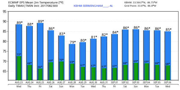
ON THE MAPS: A surface front is near the Alabama/Tennessee border early this morning, and will push southward today. Showers and storms will likely form on the front this afternoon, mostly south of I-20… otherwise today will be partly sunny with a high in the upper 80s for most communities. The northern third of the state will most likely be dry.
TOMORROW/FRIDAY: These two days will feature a good supply of sunshine, lower humidity, and cooler nights. Cooler pockets will drop down toward 60 degrees; most places will see a low in the mid 60s. Highs will be in the upper 80s.
THE ALABAMA WEEKEND: Moist air will return northward, and we will need to mention some risk of showers and storms on both days. Not a “wash-out”, but just be ready for an occasional passing shower or thunderstorm. The sky will be occasionally cloudy, and highs will be in the 81-85 degree range.
NEXT WEEK: The pattern looks wet at least for the first half of the week, but the amount of rain we get all depends on a developing tropical system in the western Gulf of Mexico. This system doesn’t have a low level center just yet, so it it simply too early to know the exact impact on our state. But, clearly, we will be on the “wet side” of the circulation.
HARVEY MAKES A COMEBACK: After degenerating in the Caribbean five days ago, Harvey is expected to develop into a tropical storm again over the next 24 hours in the Southwest Gulf of Mexico. It is expected to make landfall on the Texas coast Friday as either a strong tropical storm, or a category one hurricane. The main impact, one way or another, will be heavy rain and flooding.
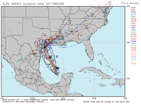
Rain amounts of 15-25″ are likely across parts of Southeast Texas and Southwest Louisiana from Friday through Sunday, setting up a dangerous flooding threat. Deeper moisture from Harvey will slide eastward and bring a fairly wet setup to states like Mississippi and Alabama next week.
INVEST 92L: A disturbance over the southern tip of Florida will hang around that same region through tomorrow, with only a low chance of organization. Some chance it could become better organized in 5-7 days as it moves northeast back into the Atlantic; one way or another this one shouldn’t have any direct impact on Alabama.
The rest of the Atlantic basin is quiet; see the Weather Xtreme video for maps, graphics, and more details.
BEACH FORECAST: Click here to see the AlabamaWx Beach Forecast Center page. The Beach Forecast is partially underwritten by the support of Brett/Robinson Vacation Rentals in Gulf Shores and Orange Beach. Click here to see Brett/Robinson’s Hot Deals now!
WEATHER BRAINS: Don’t forget you can listen to our weekly 90 minute netcast anytime on the web, or on iTunes. This is the show all about weather featuring many familiar voices, including our meteorologists here at ABC 33/40.
CONNECT: You can find me on all of the major social networks…
Facebook
Twitter
Google Plus
Instagram
Pinterest
Snapchat: spannwx
Look for the next Weather Xtreme video here by 4:00 this afternoon… enjoy the day!
Category: Alabama's Weather, ALL POSTS, Weather Xtreme Videos
About the Author (Author Profile)
James Spann is one of the most recognized and trusted television meteorologists in the industry. He holds the AMS CCM designation and television seals from the AMS and NWA. He is a past winner of the Broadcast Meteorologist of the Year from both professional organizations.Subscribe
If you enjoyed this article, subscribe to receive more just like it.


