

Harvey Ramps Up; Dangerous Situation For The Texas Coast
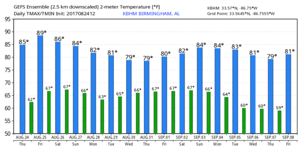
FINE DAY IN ALABAMA: Unusually dry air covers most of Alabama this afternoon. Under a sunny sky, temperatures are in the 80s, and humidity levels are low for August. Tonight will be clear and pleasant again, with cooler spots seeing upper 50s early tomorrow morning.
TOMORROW THROUGH THE WEEKEND: It now looks like dry air will stay in place, meaning mostly sunny days and fair nights tomorrow through Sunday with highs holding in the mid to upper 80s. Moisture levels will tick up a bit over West Alabama Sunday, and a few isolated showers could show up, but for now we won’t mention it in the forecast.
NEXT WEEK: Our weather all depends on Harvey, which will be in no hurry to move. We will bring in a good chance of rain and storms Wednesday night and Thursday as the remnant circulation approaches, but understand this could change. Monday and Tuesday look pretty calm for now with only isolated showers. Highs will be in the 80s through the week.
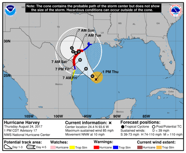
HARVEY RAMPS UP QUICKLY: Many changes since early this morning. Harvey rapidly intensified, and is now a hurricane with sustained winds of 85 mph. It is forecast to move into the Texas coast late tomorrow night as major hurricane (a strong category three) near Corpus Christi with potential for sustained winds of 125 mph and considerable storm surge flooding/damage.
It has been 4,322 days since a major hurricane landed in the U.S… Wilma on October 24, 2005.
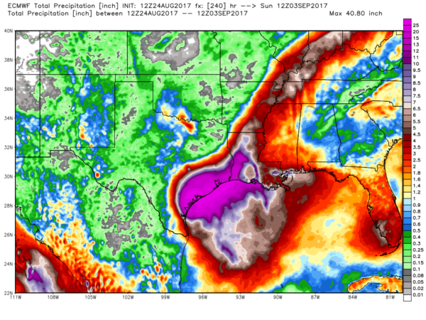
Steering currents will collapse, and Harvey is expected to meander around South Texas through early next week. This will set the stage for potentially catastrophic flooding with totals of 15-30 inches along the upper half of the Texas coast.
Houston will likely experience tropical storm force wind gusts, but flooding is the primary threat there this weekend and early next week.
INVEST 92L: The disturbance over South Florida will move northeast this weekend, and has the potential to become Tropical Storm Irma off the East Coast of the U.S. Main threat is heavy rain over South Florida over the next two days. No issues for Alabama.
BEACH FORECAST: Click here to see the AlabamaWx Beach Forecast Center page. The Beach Forecast is partially underwritten by the support of Brett/Robinson Vacation Rentals in Gulf Shores and Orange Beach. Click here to see Brett/Robinson’s Hot Deals now!
WEATHER BRAINS: Don’t forget you can listen to our weekly 90 minute netcast anytime on the web, or on iTunes. This is the show all about weather featuring many familiar voices, including our meteorologists here at ABC 33/40.
CONNECT: You can find me on all of the major social networks…
Facebook
Twitter
Google Plus
Instagram
Pinterest
Snapchat: spannwx
I enjoyed seeing everyone at the Outlet Shops at Grand River earlier today… look for the next Weather Xtreme video here by 7:00 a.m. tomorrow…
Category: Alabama's Weather, ALL POSTS, Weather Xtreme Videos
About the Author (Author Profile)
James Spann is one of the most recognized and trusted television meteorologists in the industry. He holds the AMS CCM designation and television seals from the AMS and NWA. He is a past winner of the Broadcast Meteorologist of the Year from both professional organizations.Subscribe
If you enjoyed this article, subscribe to receive more just like it.


